USGS Logo with link to USGS home page.

USGS Open File Report 2004-1400

nav2003 - Navigation Tracklines of the Puerto Rico Trench Cruise 03008 (NOAA 0303) February 18 to March 7, 2003.

nav2003 - Navigation Tracklines of the Puerto Rico Trench Cruise 03008 (NOAA 0303) February 18 to March 7, 2003.

Metadata also available as - [Questions & Answers] - [Parseable text] - [XML]

Metadata:


Identification_Information:
Citation:
Citation_Information:
Originator: U.S. Geological Survey (USGS)
Originator: The National Oceanic and Atmospheric Administration (NOAA)
Publication_Date: 2004
Title:
nav2003 - Navigation Tracklines of the Puerto Rico Trench Cruise 03008 (NOAA 0303) February 18 to March 7, 2003.
Geospatial_Data_Presentation_Form: vector digital data
Series_Information:
Series_Name: Open-File Report
Issue_Identification: 2004-1400
Publication_Information:
Publication_Place: Woods Hole Science Center, Woods Hole, MA
Publisher: U.S. Geological Survey, Coastal and Marine Geology Program
Online_Linkage:
<http://pubs.usgs.gov/of/2004/1400/data/navigation/nav2003/nav2003.zip>
Larger_Work_Citation:
Citation_Information:
Originator: Uri ten Brink
Originator: William Danforth
Originator: Castle Eugene Parker
Originator: Toshi Uozumi
Originator: Glynn Williams
Publication_Date: 2004
Title:
Project PROBE Leg II - Final Report and Archive of Swath Bathymetric Sonar, CTD/XBT and GPS Navigation Data Collected During USGS Cruise 03008 (NOAA Cruise RB0303) Puerto Rico Trench 18 February - 7 March, 2003
Series_Information:
Series_Name: Open-file Report
Issue_Identification: 2004-1400
Publication_Information:
Publication_Place: Woods Hole, MA
Publisher: Coastal and Marine Geology Program, Woods Hole Science Center
Online_Linkage: <http://pubs.usgs.gov/of/2004/1400/>
Description:
Abstract:
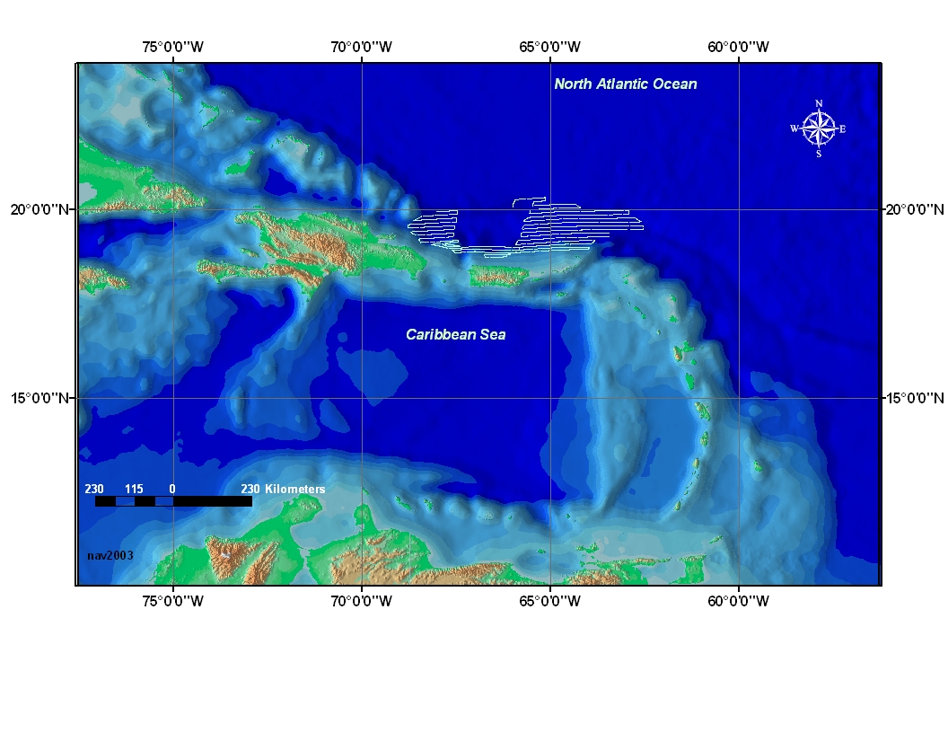
The Puerto Rico trench is a tectonic plate boundary where the North American plate slides by and descends under the Caribbean plate. Although much of the trench lies within the U.S. EEZ, surprisingly few surveys have been conducted there during the past 25 years. This data set shows the tracklines (navigation path) of the U.S. Geological Survey science cruise that was conducted in the year 2003.
Purpose:
To show the navigation path used during the U.S. Geological Survey (USGS) and National Oceanic and Atmospheric Administration (NOAA) science cruise of the Puerto Rico trench area.
Time_Period_of_Content:
Time_Period_Information:
Range_of_Dates/Times:
Beginning_Date: 20030218
Ending_Date: 20030407
Currentness_Reference: ground condition
Status:
Progress: Complete
Maintenance_and_Update_Frequency: None planned
Spatial_Domain:
Bounding_Coordinates:
West_Bounding_Coordinate: -68.847110
East_Bounding_Coordinate: -62.607258
North_Bounding_Coordinate: 20.318027
South_Bounding_Coordinate: 18.739713
Keywords:
Theme:
Theme_Keyword_Thesaurus: General
Theme_Keyword: vector coordinates
Theme_Keyword: navigation
Theme_Keyword: trackline
Theme_Keyword: polyline shapefile
Theme_Keyword: NOAA Research Cruise RB0303
Theme_Keyword: USGS Science Cruise 03008
Theme_Keyword: CMGP
Theme_Keyword: WHSC
Theme_Keyword: Woods Hole Science Center
Theme_Keyword: Coastal and Marine Geology Program
Theme_Keyword: National Oceanic and Atmospheric Administration
Theme_Keyword: NOAA Office of Ocean Exploration
Place:
Place_Keyword_Thesaurus: General
Place_Keyword: Puerto Rico
Place_Keyword: North America
Place_Keyword: Atlantic Ocean
Place_Keyword: Caribbean Sea
Access_Constraints: None
Use_Constraints:
Public domain data from the U.S. government are freely redistributable with proper metadata and source attribution. Please recognize the U.S.Geological Survey and National Oceanic Atmospheric Administration as the source of this information.
Point_of_Contact:
Contact_Information:
Contact_Organization_Primary:
Contact_Organization: U.S. Geological Survey
Contact_Person: Chris Polloni
Contact_Position: Information Specialist
Contact_Address:
Address_Type: mailing and physical address
Address: 384 Woods Hole Road
City: Woods Hole Road
State_or_Province: Massachusetts
Postal_Code: 02543-2310
Country: USA
Contact_Voice_Telephone: (508) 548-8700.x2280
Contact_Facsimile_Telephone: (508) 457-2310
Contact_Electronic_Mail_Address: cpolloni@usgs.gov
Hours_of_Service: 8:00AM to 5:00PM; M- F
Native_Data_Set_Environment:
Microsoft Windows 2000 Version 5.1 (Build 2600) Service Pack 2; ESRI ArcCatalog 8.3.0.800

Data_Quality_Information:
Lineage:
Source_Information:
Source_Citation:
Citation_Information:
Publication_Date: Unpublished Material
Type_of_Source_Media: disc
Source_Time_Period_of_Content:
Time_Period_Information:
Range_of_Dates/Times:
Beginning_Date: 20030218
Ending_Date: 20030307
Source_Currentness_Reference: ground condition
Process_Step:
Process_Description:
The navigation was received from the R/V Ron Brown GPS network during USGS cruise RONB02051 (NOAA RB0208), sent directly to the central storage system and logged each day to a spreadsheet file that was archived to a CD-ROM.
Process_Date: 2004
Process_Contact:
Contact_Information:
Contact_Person_Primary:
Contact_Person: Chris Polloni
Contact_Organization: U.S. Geological Survey
Contact_Position: Information Specialist
Contact_Address:
Address_Type: mailing and physical address
Address: 384 Woods Hole Road
City: Woods Hole
State_or_Province: Massachusetts
Postal_Code: 02543-1589
Country: USA
Contact_Voice_Telephone: (508) 548-8700 x2280
Contact_Facsimile_Telephone: (508) 457-2310
Contact_Electronic_Mail_Address: cpolloni@usgs.gov
Hours_of_Service: 8AM to 5PM; M-F
Process_Step:
Process_Description:
The navigation spreadsheet file was reformatted as table input file for ArcView.
Process_Date: 2004
Process_Contact:
Contact_Information:
Contact_Person_Primary:
Contact_Person: Chris Polloni
Contact_Organization: U.S. Geological Survey
Contact_Position: Info Specialist
Contact_Address:
Address_Type: mailing and physical address
Address: 384 Woods Hole Road
City: Woods Hole
State_or_Province: Massachusetts
Postal_Code: 02543-1589
Country: USA
Contact_Voice_Telephone: 508-457-2280
Contact_Facsimile_Telephone: (508) 457-2310
Contact_Electronic_Mail_Address: cpolloni@usgs.gov
Process_Step:
Process_Description:
navigation table file saved as trackline shapefile. ArcView 3.3 used to process shapefile.
Process_Date: 2004
Process_Contact:
Contact_Information:
Contact_Person_Primary:
Contact_Person: Chris Polloni
Contact_Organization: U.S. Geological Survey
Contact_Position: Info Specialist
Contact_Address:
Address_Type: mailing and physical address
Address: 384 Woods Hole Road
City: Woods Hole
State_or_Province: Massachusetts
Postal_Code: 02543-1589
Country: USA
Contact_Voice_Telephone: 508-457-2280
Contact_Facsimile_Telephone: (508) 457-2310
Contact_Electronic_Mail_Address: cpolloni@usgs.gov

Spatial_Data_Organization_Information:
Direct_Spatial_Reference_Method: Vector
Point_and_Vector_Object_Information:
SDTS_Terms_Description:
SDTS_Point_and_Vector_Object_Type: String
Point_and_Vector_Object_Count: 80

Spatial_Reference_Information:
Horizontal_Coordinate_System_Definition:
Geographic:
Latitude_Resolution: 0.00001
Longitude_Resolution: 0.00001
Geographic_Coordinate_Units: Decimal degrees
Geodetic_Model:
Horizontal_Datum_Name: D_WGS_1984
Ellipsoid_Name: WGS_1984
Semi-major_Axis: 6378137.000000
Denominator_of_Flattening_Ratio: 298.257224
Vertical_Coordinate_System_Definition:
Altitude_System_Definition:
Altitude_Datum_Name: assumed sea level
Altitude_Resolution: 1
Altitude_Distance_Units: two-way travel time (meters)
Altitude_Encoding_Method: Attribute values
Depth_System_Definition:

Entity_and_Attribute_Information:
Detailed_Description:
Entity_Type:
Entity_Type_Label: nav2003
Entity_Type_Definition: Shapefile Attribute Table
Entity_Type_Definition_Source: ESRI
Attribute:
Attribute_Label: FID
Attribute_Definition: Internal feature number.
Attribute_Definition_Source: ESRI
Attribute_Domain_Values:
Unrepresentable_Domain:
Sequential unique whole numbers that are automatically generated.
Attribute:
Attribute_Label: Shape
Attribute_Definition: Feature geometry.
Attribute_Definition_Source: ESRI
Attribute_Domain_Values:
Unrepresentable_Domain: Coordinates defining the features.
Attribute:
Attribute_Label: ID
Attribute_Definition:
A unique character string or numeric value associated with a particular object.
Attribute_Definition_Source: ESRI

Distribution_Information:
Distributor:
Contact_Information:
Contact_Person_Primary:
Contact_Person: Uri ten Brink
Contact_Organization: U.S. Geological Survey
Contact_Position: Research Scientist
Contact_Address:
Address_Type: physical address
Address: 384 Woods Hole Road
City: Woods Hole
State_or_Province: Massachusetts
Postal_Code: 02543-1598
Country: USA
Contact_Voice_Telephone: (508) 548-8700 x2396
Contact_Facsimile_Telephone: (508) 457-2310
Contact_Electronic_Mail_Address: utenbrink@usgs.gov
Hours_of_Service: 8:00AM to 5:00PM; M-F
Resource_Description: Downloadable Data: Open-File Report 2004-1400 - nav2003
Standard_Order_Process:
Digital_Form:
Digital_Transfer_Information:
Transfer_Size: 0.157

Metadata_Reference_Information:
Metadata_Date: 20041102
Metadata_Contact:
Contact_Information:
Contact_Organization_Primary:
Contact_Organization: U.S. Geological Survey
Contact_Person: Glynn Williams
Contact_Position: Spatial Data Technician
Contact_Address:
Address_Type: physical address
Address: 384 Woods Hole Road
City: Woods Hole
State_or_Province: Massachusetts
Postal_Code: 02543-1598
Country: USA
Contact_Voice_Telephone: (508) 548-8700 x2290
Contact_Facsimile_Telephone: (508) 457-2310
Contact_Electronic_Mail_Address: gwilliams@usgs.gov
Hours_of_Service: 8:00AM to 5:00PM
Metadata_Standard_Name: FGDC Content Standards for Digital Geospatial Metadata
Metadata_Standard_Version: FGDC-STD-001-1998
Metadata_Time_Convention: local time
Metadata_Access_Constraints: None
Metadata_Use_Constraints: None
Metadata_Extensions:
Online_Linkage: <http://www.esri.com/metadata/esriprof80.html>
Profile_Name: ESRI Metadata Profile

Generated by mp version 2.8.18 on Fri Dec 17 16:19:42 2004