The Dry Tortugas National Park
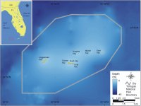 |
| Figure 1. Location of Dry Tortugas National Park in Florida. Click on figure for larger image. |
The atoll-like, coral and carbonate sand islands of the Dry Tortugas lie about 110 km (~70 miles) west of Key West in Florida (Figure 1). These islands formed during the Holocene as wave processes in combination with a slow-steady rise in sea-level worked limestone and coral into mounds of carbonate sand with thicknesses ranging from 14 - 18 m (~45 - 55 ft) (Shinn et al, 1977). These islands were named Las Tortugas by Spanish explorer Ponce de Leon because of the large number of turtles inhabiting these islands. Later Dry was added to the name on nautical charts to let mariners know that there was no fresh water on the islands.
The largest brick structure in the Western Hemisphere is located on Garden Key and is nineteenth century Fort Jefferson. Construction began in 1846 as part of the US coastal fortification efforts following the War of 1812, but the fort was never completed. Fort Jefferson was used as a military prison during the Civil War, but was abandoned by the Army in 1874. In 1908 the Dry Tortugas were declared a wildlife refuge, then in 1935 Fort Jefferson National Monument was established, creating the first underwater park unit. In 1992 the area became Dry Tortugas National Park.
Hurricanes passing through the Gulf of Mexico are always reshaping the islands and leaving their mark on Fort Jefferson. During 2004 when Hurricane Charley passed over the Dry Tortugas, the landbridge connecting Bush Key to Garden Key washed over, but within a few hours the spit reformed (M. Ryan, personal communication, Oct. 29, 2004). Although storm impacts are not directly addressed in this report it is important to acknowledge their role in the dynamic evolution of the Dry Tortugas. Further the authors acknowledge that the islands of the Dry Tortugas owe their continued existence to coral reef productivity, which is vulnerable to not only expected accelerated sea-level rise, but also hurricane damage, increased water temperature, boat anchoring, coral disease, and fishing. Coral reef health and productivity is not directly addressed in this methodology.