Skip Links

Skip USGS links group
USGS - science for a changing world
NOAA logo with link to NOAA home page   logo with link to CT Dept. of environmental protection  home page

Open-File Report 2005-1018

Prepared in cooperation with National Oceanic and Atmospheric Administration and Connecticut Department of Environmental Protection

U.S. Geological Survey Open-File Report 2005-1018

Surficial Geologic Interpretation and Sidescan Sonar Imagery
of the Sea Floor in West-Central Long Island Sound

By K.Y. McMullen1, L.J. Poppe1, V.F. Paskevich1, E.F. Doran2, M.S. Moser3,  E.B. Christman3 and A.L Beaver4

Skip Table of Contents
OFR 2005-1018 Home

Introduction

Geologic Setting

Data Acquisition and Processing

Sidescan Imagery

GIS Data Catalog

References

Figures List

Acknowledgments

Contacts

Disclaimer

README


September 2005

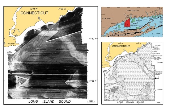
OFR2005-1018 index image sidescan sonar mosaic of study area, study location map, and interpretive map.

COLLABORATORS


National Oceanic and Atmospheric Administration Connecticut EPA


1 -  U.S. Geological Survey
Coastal and Marine Geology

Woods Hole Science Center
384 Woods Hole Road
Woods Hole, MA 02543-1598

(508) 548-8700
2 -  Connecticut Department of Environmental Protection
79 Elm Street
Hartford, CT 06106

(860) 424-3721
3 -  National Oceanic and
Atmospheric Administration

NOAA Ship Thomas Jefferson
439 West York Street
Norfolk, VA 23510

(757) 647-0187
4 -  National Oceanic and
Atmospheric Administration

Northeast Region

28 Tarzwell Drive
Narragansett, RI 02882

(401) 782-3252

Accessibility FOIA Privacy Policies and Notices

Take Pride in America logo USA.gov logo U.S. Department of the Interior | U.S. Geological Survey
URL: http://pubsdata.usgs.gov/pubs/of/2005/1018/index.htm
Page Contact Information: GS Pubs Web Contact
Page Last Modified: Wednesday, 15-May-2024 08:14:00 EDT