
 |
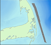
CAPESOUTHSUN_GEO4M_WGS84.TIF: Image of the 4-m Sun-illuminated Topography of the Sea Floor off Eastern Cape Cod (Geographic) |
Metadata also available as: FAQ | TEXT
The sun-illuminated topographic (shaded relief) image has a 4-m pixel size and was created by vertically exaggerating the topography two times and then artificially illuminating the relief by a light source positioned 45 degrees above the horizon from an azimuth of 0 degrees. In the resulting image, topographic features are enhanced by strong illumination on the northwestward-facing slopes and by shadows cast on southeastern slopes. The image also accentuates small features (relief of a few meters) that could not be effectively shown as contours alone at this scale. Unnatural-looking features or patterns oriented parallel or perpendicular to survey tracklines are artifacts of data collection and environmental conditions
The data have a weak striping that runs parallel to the ship's track. Some of the striping is the result of poor data return at nadir that appears as evenly-spaced thin speckled lines. Some striping is also due to critical angle effects, where the intensity of return varies as a function of the angle of incidence of the incoming sound on the seafloor (Hughes-Clark and others, 1997).
Public domain data are freely redistributable with proper metadata and source attribution. Please recognize the U.S. Geological Survey (USGS) as the source of this information.
After the echo sounder data were logged onto the hard disk of the Sun workstation, a suite of processing software developed by the Ocean Mapping Group (www.omg.unb.ca/~jhc/SwathEd.html) was used to correct for artifacts and errors that may have been introduced during data collection. This software also enhanced the corrected data by resolving beam pattern and aspect ratio distortions and by imposing a linear contrast stretch before it generated bathymetric and sidescan sonar image mosaicks in a Mercator projection. All data processing described here is initiated using Silicon Graphics workstations as soon as each acquisition file is closed by the Simrad Mermaid workstation (usually at the end of each survey line). Additional processing was done in the lab to correct for fluctuations in sea level during the survey and for artifacts in the data files that were not corrected in the field (see below).
(2) The processing and editing steps on board the ship were:
(A.) Demultiplex, or unravel, the acquired Simrad data files using RT to generate separate files containing navigation, depth soundings, sidescan sonar backscatter values, and sound velocity information.
(B.) Automatically reject bad data (autoRejectSoundings). For the multibeam soundings, reject data outside expected depth ranges (operator's decision based on nautical chart data); for navigation data, reject fixes with poor GPS statistics.
(C.) Edit the navigation data on-screen using jview to remove undesirable points, including turns at the ends of survey lines.
(D.) Edit the multibeam soundings on-screen using swathed to remove individual anomalous soundings.
(E). Merge tidal information and the corrected navigation back (mergetide and mergenav) into the data files. Tidal information was obtained from predicted tides using the Xtide program <http://www.flaterco.com/xtide/xtide.html>), which generated predicted tides based on the harmonic coefficients for Chatham provided by the Xtide program.
(F.) Map the bathymetric soundings from each processed data file onto a Mercator grid using weigh_grid (a SwathEd utility) with node spacings and scale selected by the operator. The grid file (capesouth.r4) was a floating point binary file.
Any use of trade, product, or firm names is for descriptive purposes only and does not imple endorsement by the U.S. Government.