Open-File Report 2005-1048
OFR 2005-1048 Home / Introduction / Geologic Setting / GIS Data Catalog / Bottom Photographs
U.S. Geological Survey Open-File Report 2005-1048
Geological Interpretation of Bathymetric and Backscatter Imagery of the Sea Floor Off Eastern Cape Cod, Massachusetts
|
|
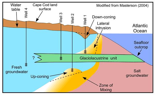
Figure 25
Schematic drawing modified from Masterson (2004) showing how fine-grained glaciolacustrine units can affect the position of the salt water/freshwater interface in well fields on Cape Cod. These units limit recharge causing saltwater intrusion and downconing of surface waters in wells drilled to above the fine-grained units (Well 1), upconing of salt water in wells drilled to below these units (Well 2), and poor flow rate in wells drilled into the glaciolacustrine sediments (Well 3). |
|
|
|
|

![]() U.S. Department of the Interior |
U.S. Geological Survey
U.S. Department of the Interior |
U.S. Geological Survey
URL: http://pubsdata.usgs.gov/pubs/of/2005/1048/htmldocs/figures/f25_cchydrog.htm
Page Contact Information: GS Pubs Web Contact
Page Last Modified: Tuesday, 03-Sep-2024 14:45:03 EDT