[an error occurred while processing this directive] Skip title; go to table of contents

U.S. Geological Survey Open-File Report 2005-1048

Geological Interpretation of Bathymetric and Backscatter Imagery of the Sea Floor Off Eastern Cape Cod, Massachusetts

INTRODUCTION

Skip Table of Contents; Go to ContentOFR 2005-1048 Home
Introduction
Geologic Setting
Methods
Geologic Interpretation
Bottom Photographs
GIS Data Catalog
Maps
References
Figures
Contacts
Disclaimer

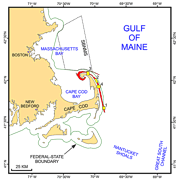
The imagery, interpretive data layers, and data presented herein were derived from multibeam echo-sounder data collected off Eastern Cape Cod, Massachusetts, and from the stations occupied to verify these acoustic data. The basic data layers show sea-floor topography, sun-illuminated shaded relief, and backscatter intensity; interpretive layers show the distributions of surficial sediment and sedimentary environments. Presented verification data include new and historical sediment grain-size analyses and a gallery of still photographs of the seabed.

Index map of Cape Cod and the Islands showing the multibeam coverage.

Figure 1: Index map of Cape Cod and the Islands showing the multibeam coverage.

The multibeam data, which cover a narrow band of the sea floor extending from Provincetown around the northern tip of Cape Cod and south southeastward to off Monomoy Island, were collected during transits between concurrent mapping projects in the Stellwagen Bank National Marine Sanctuary (Valentine and others, 2001; Butman and others, 2004; and Valentine, 2005) and Great South Channel (Valentine and others, 2003a, b, c, d). Although originally collected to maximize the use of time aboard ship, these data provide a fundamental framework for research and management activities in this part of the Gulf of Maine (Noji and others, 2004), show the composition and terrain of the seabed, and provide information on sediment transport and benthic habitat. These data and interpretations also support ongoing modeling studies of the lower Cape’s aquifer system (Masterson, 2004) and of erosional hotspots along the Cape Cod National Seashore (List and others, 2006).
[an error occurred while processing this directive]