

Map of Coastal
Vulnerability
 |
War in the Pacific National Historical Park
The Mariana Archipelago is an island arc chain that exists as a result of the subduction of the Pacific Plate beneath the Philippine Plate (http://volcano.und.edu/vwdocs/volc_images/southeast_asia/mariana/basic_geology.html). Guam lies about 5,300 km (~3,300 miles) southwest of Hawaii, and it is the largest and southern-most island of the Marianas (Figure 1). Guam is composed of two distinct geologic units, volcanic mountains to the south and a limestone plateau in the north. Most of the island is surrounded by a fringing coral reef that helps buffer the coast from open Pacific Ocean waves and storms. However, coral reefs on Guam are vulnerable not only to expected sea-level rise acceleration, but also to storm damage, increased water temperatures, coral diseases, and land runoff and sedimentation. Because coral reef systems need light to grow, sea-level rise will likely result in death to ecosystems at the depth limit of light penetration 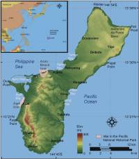 |
| Figure 1. Location of War in the Pacific NHP, Guam. |
(Hoegh-Guldberg, 1999). Some scientists would argue that sea-level rise alone could result in increased coral growth by providing more 'headroom' for ecosystems that have reached their limit of vertical growth. Although this could be a scenario, sea-level rise is likely to be accompanied by increased water temperatures and changes in salinity, which could further damage or stress coral ecosystems. Further, slow growing corals may not be able to keep pace with potential increases in the rate of sea-level rise (Hoegh-Guldberg 1999; Graus, 1998).
Other natural hazards that impact coastal evolution on Guam include tropical cyclones (Richmond and Jaffe, 1991) and tsunamis (Lander and others, 2002). In December 2002 super typhoon Pongsona resulted in severe damage to the park Visitor's Center, and in 2004 super typhoon Chaba caused extensive overwash and erosion along the park shoreline.
Guam supports a diverse ecosystem that War in the Pacific National Historical Park is preserving. In addition to the many natural resources along this coast, there are significant cultural resources within the park as old as 2000 years and extend through Guam's role in the Pacific Theater of World War II (for more information on the park's historical and cultural resources please see: http://www.nps.gov/wapa/indepth/.
|
|