Calculating the Vulnerability Index
The coastal vulnerability index (CVI) presented here is the same as that used in Thieler and Hammar-Klose (1999) and is similar to that used in Gornitz and others (1994), as well as to the sensitivity index employed by Shaw and others (1998). The (CVI) allows the six variables to be related in a quantifiable manner that expresses the relative vulnerability of the coast to physical changes due to future sea-level rise. This method yields numerical data that cannot be equated directly with particular physical effects. It does, however, highlight areas where the various effects of sea-level rise may be the greatest. Once each section of coastline is assigned a vulnerability value for each specific data variable, the coastal vulnerability index (CVI) is calculated as the square root of the product of the ranked variables divided by the total number of variables;
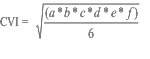
where, a=geomorphology, b=shoreline erosion/accretion rate, c=coastal slope, d=relative sea-level change rate, e=mean significant wave height, and f=mean tide range. The calculated (CVI) value is then divided into quartile ranges to highlight different vulnerabilities within the park. The (CVI) ranges (low—very high) reported here apply specifically to Point Reyes National Seashore, and are not comparable to (CVI) ranges in other parks where the (CVI) has been employed (i.e. very high vulnerablity means the same among parks; it's the numeric values that differ, such that a numeric value that equals very high vulnerability in one park may equal moderate vulnerability in another). To compare vulnerability between coastal parks, the national-scale studies should be used (Thieler and Hammar-Klose, 1999, 2000a, and 2000b). We feel this approach best describes and highlights the vulnerability specific to each park.