USGS Open-File Report 2005-1231
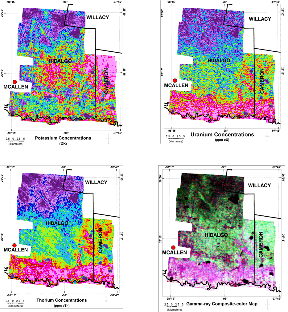
The gamma-ray data collected as part of the aerial survey were processed by the contractor to produce estimates of the concentrations of potassium, uranium, and thorium in the upper 30 cm of the rocks and soils (Duval, Cook, and Adams, 1971). The potassium concentrations are based upon the measurement of gamma-rays emitted by the radioactive isotope potassium-40 (K40) and are expressed as percent potassium (% K). The uranium concentrations are estimated using gamma-rays from the radioactive isotope bismuth-214 (Bi214) which is a daughter product of uranium-238 (U238). The use of a daughter product to estimate the concentration of the parent nuclide assumes that the radioactive decay series of the parent is in radioactive equilibrium. Because that assumption may not be true, the concentrations are given as parts per million of equivalent uranium (ppm eU). The thorium concentrations are estimated using gamma-rays from the radioactive isotope thallium-208 (Tl208) which is a daughter product of thorium-232 (Th232). As in the case of uranium, radioactive equilibrium is assumed and the concentrations are given as parts per million of equivalent thorium (ppm eTh)
The corrections applied to the data by the contractor include background, altitude, airborne bismuth-214, and Compton scattering. The background corrections removed the effects of radioactivity in the aircraft and survey instruments as well as counts due to cosmic radiation. The altitude corrections applied by the contractor used a calculated effective altitude that takes into account variations in the density of the air caused by pressure and temperature variations. The airborne bismuth-214 correction uses data from a detector that is partially shielded from gamma-rays that originate in the ground. This shielded detector provides a measure of the amount of radiation from bismuth-214 sources in the atmosphere. Such sources are produced by the decay of radioactive radon-222 (Rn222) that escapes form the soil gas in the ground into the air. Compton scattering corrections remove the effects of gamma-rays scattered in the ground, atmosphere, and/or in the detectors. For more detailed information about the data processing refer to the report provided by the contractor to the USGS.
The data were provided to the USGS as profiles along flightlines. Using a minimum curvature algorithm and the data of those profiles, grids with a cell size of 50 m were calculated for each radioactive element. The figure below shows maps of the grids. The composite-color map (CCM) combines the uranium data as shades of red, the potassium as shades of green, and the thorium as shades of blue. Click on a map to view a higher resolution image of the map. You can also display the color legends for a map by clicking on the map name here (potassium, uranium, thorium, CCM).
![]() Aerial Survey | Gamma-ray Classification
Aerial Survey | Gamma-ray Classification ![]()

![]() U.S. Department of the Interior |
U.S. Geological Survey
U.S. Department of the Interior |
U.S. Geological Survey
URL: http://pubsdata.usgs.gov/pubs/of/2005/1231/gammadata.htm
Page Contact Information: Stephen Snyder
Page Last Modified: Saturday, 12-Jan-2013 21:27:57 EST