The Kaloko-Honokohau National Historical Park
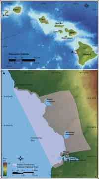 |
| Figure 1. Location of Kaloko-Honokohau National Historical Park, Hawaii. |
Kaloko-Honokohau National Historical Park (NHP) lies on Hawaii, the largest of the Hawaiian Islands, in an area just north of the Kailua-Kona coast (fig. 1). The oldest Hawaiian Island, Kauai, began forming about 5 million years ago and the youngest island, Hawaii, continues to grow today (Hazlett and Hyndman, 1996). For more information and links to Hawaii geology see http://geology.wr.usgs.gov/stateinfo/HI.html. The coastal areas in Kaloko-Honokohau NHP consist mostly of large, dry, rugged lava flows some of which are just over a thousand years old (Wolfe and Morris, 1996). The shoreline is primarily rocky basalt with storm beach deposits (60%) which are locally interrupted by sections of intertidal beach or fishponds (Hapke and others, 2005). Most of the coast is paralleled by shallow fringing reefs, which are vulnerable to not only expected sea-level rise, but also to storm damage, increased water temperatures, and land runoff and sedimentation (for more information on coral reefs in the Hawaiian Islands see: USGS Pacific Coral Reefs and Hawaii Coral Reef Network).
Because coral reef systems need light to grow, sea-level rise could result in death to ecosystems at the depth limit of light penetration (Hoegh-Guldberg, 1999). Some scientists would argue that sea-level rise alone could result in increased coral growth by providing more 'headroom' for ecosystems that have reached their limit of vertical growth. Although this is a possible scenario, sea-level rise is likely to be accompanied by increased water temperatures and changes in salinity, which could further damage or stress coral ecosystems. Further, slow growing corals may not be able to keep pace with potential increases in the rate of sea-level rise (Hoegh-Guldberg 1999; Graus, 1998). In addition to the many natural and biologic resources along the Kona coast, there are also significant cultural resources within the park such as a historical Hawaiian settlement with fishponds, petroglyphs, and religious sites (heiau).