Title Page /
Abstract /
Report /
Figures /
References /
Acknowledgements /
Disclaimer
|
||
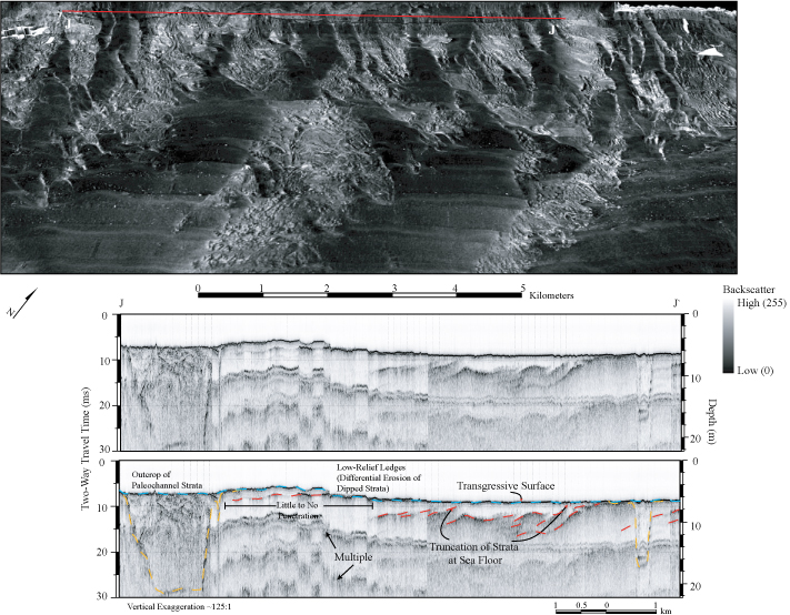
Figure 13. Sidescan-sonar imagery and chirp seismic-reflection profile directly offshore of Myrtle Beach. See figure 4 for figure location. Top: Perspective view of sidescan-sonar imagery draped over bathymetry, showing the complex patterns of high and low backscatter characteristic of the area. Low-relief, shore-normal ridges are displayed in the nearshore. Bottom: Chirp seismic-reflection profile directly offshore of Myrtle Beach. Profile displays Pleistocene channels (yellow) and Cretaceous strata (red) exposed at the sea floor and differential erosion of outcropping Cretaceous strata. Transgressive surface (blue) and sea floor are outlined (green). Vertical scales show milliseconds (Two-way travel time) and approximate depth assuming a seismic velocity of 1500 m/sec. Figure modified from figure 12, Baldwin and others (2004). | ||

![]() U.S. Department of the Interior |
U.S. Geological Survey
U.S. Department of the Interior |
U.S. Geological Survey
URL: http://pubsdata.usgs.gov/pubs/of/2005/1345/html/imagepages/fig13.html
Page Contact Information: Publishing Services
Page Last Modified: Saturday, 12-Jan-2013 22:12:21 EST