|
|
Introduction
|
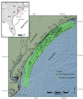
Figure 1. Location map of the study area showing geophysical tracklines and surficial grab sample locations.
Click on figure for larger image and full caption.
|
The northeastern South Carolina coast (fig. 1) is a heavily developed region that supports a thriving tourism industry, large local populations and extensive infrastructure. The economic stability of the region is closely tied to the health of its beaches; primarily in providing support for local tourism and protection from storm events. Despite relatively low long-term shoreline erosion rates (~1 m/yr in some areas) (Anders and others, 1985; Morton and Miller, 2005), and the implied stability of the beaches, the economic impact of storm events to coastal communities has been costly. For example, Hurricane Hugo made landfall on the central South Carolina coast in 1989. High winds and storm surge inflicted roughly $6 billion in property loss and damages and remains the costliest storm event in South Carolina history (Gayes, 1991). Localized erosion, commonly occurring around tidal inlets and erosion “hot spots,” has also proved costly. Construction and maintenance of hard structures and beach nourishment, designed to mitigate the effects of erosion, have become annual or multi-annual expenditures (Gayes, 1991; Putney and others, 2004). Providing a better understanding of the physical processes controlling coastal erosion and shoreline change will allow for more effective management of coastal resources.
In 1999, the U.S. Geological Survey (USGS), in partnership with the South Carolina Sea Grant Consortium (SCSGC), began a study to investigate inner continental shelf and shoreface processes. Previous work shows that modern beach behavior and morphology of coastlines with limited sediment supply are heavily influenced by the structure and composition of older geologic strata located beneath and seaward of the shoreface (Milliman and others, 1972; Pilkey and others, 1981; Riggs and others, 1995, 1996, 1998; Schwab and others, 1997; 2000; Thieler and others, 1995, 2001; Boss and others, 2002). The objectives of the USGS/SCSGC cooperative program are: 1) to provide a regional synthesis of the shallow geologic framework underlying the shoreface and inner continental shelf and define its role in coastal evolution and modern beach behavior; 2) to identify and model the physical processes affecting coastal ocean circulation and sediment transport and to define their role in shaping the modern shoreline; and 3) to identify sediment sources and transport pathways, ultimately leading to construction of a regional sediment budget. This study builds upon the work of Baldwin and others (2004), by describing inner shelf morphology and surficial sediment distribution and qualitatively assessing modern sediment transport pathways.
|

 Back to Previous Section
 Forward to Next Section