Title Page /
Abstract /
Report /
Figures /
References /
Acknowledgements /
Disclaimer
 |
||
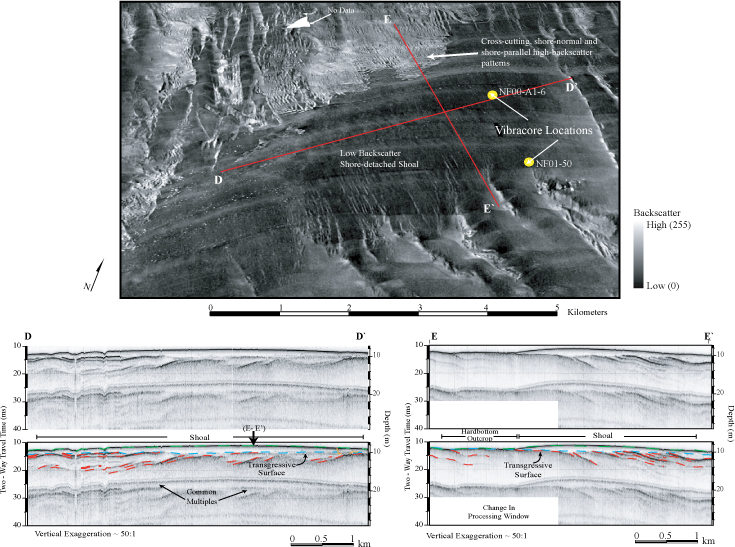
Figure 8. Sidescan-sonar imagery and chirp seismic-reflection profiles on the inner shelf offshore of northern Myrtle Beach. See figure 4 for figure location. Top: Perspective view of sidescan-sonar imagery draped over bathymetry showing the low-backscatter, shore-oblique shoal and adjacent high-backscatter areas. A complex pattern of shore-normal and shore-parallel high-backscatter lies directly shoreward of the shoal. Yellow circles denote core locations: see Appendix B1 and B2 for core descriptions. Bottom: Chirp seismic-reflection profiles across shoal show the thickness of sediment associated with the shoal (area between green and blue), and the transgressive surface (blue) and truncated Cretaceous strata underlying the shoal (red). Depth is approximate and assumes a seismic velocity of 1500 m/sec. Figure modified from Baldwin and others (2004, their figure 18). | ||

![]() U.S. Department of the Interior |
U.S. Geological Survey
U.S. Department of the Interior |
U.S. Geological Survey
URL: http://pubsdata.usgs.gov/pubs/of/2005/1345/html/imagepages/fig8.html
Page Contact Information: Publishing Services
Page Last Modified: Saturday, 12-Jan-2013 22:12:33 EST