Open-File Report 2005-1346
| Introduction: South Carolina Coastal Erosion Study
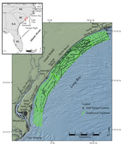
The northern South Carolina coast is a heavily developed region that supports a thriving tourism industry,
large local populations and extensive infrastructure (Figure 1). The economic stability of the region is closely
tied to the health of its beaches: primarily in providing support for local tourism and protection from storm events.
Despite relatively low long-term shoreline erosion rates, and the implied
stability of the beaches, the economic impact of storm events to coastal communities has been costly. For example,
Hurricane Hugo made landfall on the central South Carolina coast in 1989. High winds and storm surge inflicted roughly
$6 billion in property loss and damages, and Hugo remains the costliest storm event in South Carolina history.
Localized erosion, commonly occurring around tidal inlets and erosion "hot spots", has also proved costly. Construction
and maintenance of hard structures and beach nourishment, designed to mitigate the effects of erosion, have become
annual or multi-annual expenditures. Providing a better understanding of the
physical processes controlling coastal erosion and shoreline change will allow for more effective management of coastal resources. This report contains the geospatial data used to define the geologic framework offshore of the northern South Carolina coast. The digital data presented herein accompany USGS Open-File Reports OFR 2004-1013 and OFR 2005-1345, describing the stratigraphic framework and modern sediment distribution within Long Bay, respectively. Direct on-line links to these publications are available within 'References' on the navigation bar to the left. Additional links to other publications and web sites are also available.
|

![]() U.S. Department of the Interior |
U.S. Geological Survey
U.S. Department of the Interior |
U.S. Geological Survey
URL: http://pubsdata.usgs.gov/pubs/of/2005/1346/html/intro.html
Page Contact Information: GS Pubs Web Contact
Page Last Modified: Tuesday, 02-Jul-2024 16:07:24 EDT

 Back to Previous Section
 Forward to Next Section