U.S. Geological Survey Open-File Report 2005-1428
Digital Mapping Techniques '05—Workshop Proceedings
Each year, new geologic map data produced under contract to the USGS National Cooperative Geologic Mapping Programs STATEMAP program are in high demand in New Mexico. Scientists, decision makers, engineers, and others request or need these data for many reasons, as soon as possible. Given that cartographic production, reviews, and the application of map standards set by the New Mexico Bureau of Geology and Mineral Resources are lengthy processes, the Bureau has created a new Preliminary Map Series. These draft map data are now available for download as PDF files from the Bureaus website in early June of each year, immediately after completion of the mapping and delivery of the STATEMAP contractual requirement to the USGS. These preliminary maps are either cleaned and rectified scans of authors original greenline mylars, or original digital (vector) linework data that are placed into a draft layout template that includes rudimentary ancillary data (cross sections, map unit descriptions, correlation charts, photos, etc.). The draft map is then uploaded to the Bureau website, for public access. After digitization, attributing, and labeling of the map and cross sections, this online preliminary map is replaced by a full-color, but still preliminary, version of the map; after peer review, that map is superceded by the final version published in the Bureaus formal Geologic Map Series.
In New Mexico, geologic maps are in high demand by the government (scientists, decision makers), private industry (engineers, etc.), academia, and by the general public. Geologic maps combine descriptive information (such as materials and structures) and interpretations (e.g., geologic processes) into a conceptual framework that relates all of the geologic elements through time. It is a powerful tool that describes the geologic environment and permits us to predict how natural systems are likely to behave in the future. In addition, they provide immediate economic benefits, adding up to many millions of dollars saved.
Studies have shown that geologic information is important to government and private industry for a variety of environmental and economic applications, with the following being the most common applications:
Specifically in New Mexico, new geological quadrangle maps produced by the New Mexico Bureau of Geology and Mineral Resources STATEMAP program are being used to support a great variety of environmental and hydrologic work throughout the state, especially along the Rio Grande where a majority of the states population lives.
The Bureaus STATEMAP mapping priorities are set annually by a 35-member STATEMAP Advisory Committee (SMAC), composed of hydrologists, geologists, and planners from state, local, federal, tribal, and private agencies and entities. The quadrangles to be mapped are selected based on their potential to provide essential earth science data to planners, engineers, geologists, and hydrologists. Our mapping program is especially important to New Mexico because, of the approximately 2000 7.5-minute quads in the state, less than 25% have been mapped at the standard scale of 1:24,000. The most critical unmapped areas are along the population centers of the Rio Grande corridor. Therefore, it is not surprising that much interest is generated each spring when the Bureau finishes a new set of 24K geologic quadrangles (usually around 10-12 per year).
Unfortunately, formal cartographic production of these maps cannot keep pace with actual geologic mapping. In addition to the time consuming processes of digital data capture and layout, each map must go through both scientific and editorial review, and must meet Bureau map standards, before they are finally released as official Bureau geologic maps in its Geologic Map (GM) publication series. This often adds an additional year or more to each quad beyond the point where a) the map is delivered to the USGS as per contractual requirement, and b) the geologist(s) deem the mapping sufficiently stable (complete) for production to commence. For many people who want the map data, this lengthy process is unacceptable. Hence, the Bureau developed its Preliminary Map Series, to expedite map data dissemination.
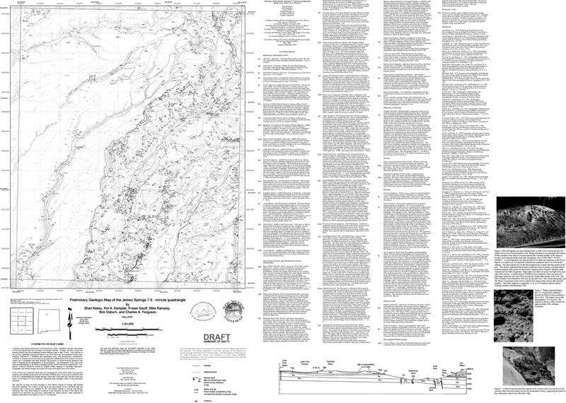
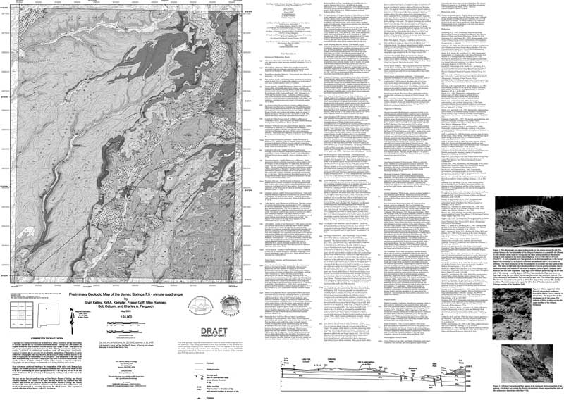
Now, each May, prior to contractual delivery to the USGS, each map is put into a DRAFT preliminary layout template, which contains ancillary data such as cross sections, correlation charts, report, photos, well data, etc. (Figure 1a). This is usually accomplished by scanning, cleaning, and rectifying each new maps greenline mylar (which shows the geology and the base map), and inserting these data into an ArcGIS preliminary map template (see Figure 1b for details of the map shown in Figure 1a). Occasionally, actual digital linework vector data are provided by the compiler, and these are used. As hard copy delivery is made to the USGS at the end of each May, a PDF file of each draft preliminary map is uploaded to the Bureaus STATEMAP webpage, for public access. Thus, map data are immediately available. After the map linework has been digitized and map polygons have been attributed and labeled in ArcGIS, the map proceeds to the second phase of the Preliminary Map Series, as the rectified scan of the greenline is replaced with the ArcMap file and uploaded to the public site to replace the draft map (Figure 2a and 2b; note that whereas these figures are in grayscale, the available maps are in 24 bit CMYK color). The map then is processed through final layout and review. Upon completion, the Preliminary Map is superseded and replaced by a map formally published in the Bureaus Geologic Map (GM) Series.
 |
|
Figure 1a. Draft version of the geologic map of the Jemez Springs quadrangle, published in the Bureau’s Preliminary Map Series (map scale 1:24,000; paper size 36”x 50”). Scanned geologic greenlines, or digital vector linework data placed upon a greenline raster base, are cleaned and rectified, and placed in the draft map layout, with Microsoft Word text (map unit descriptions, etc.) and original hand-drafted ancillary data (cross sections, correlation charts, etc.) and photos. This map is available in PDF format. |
|
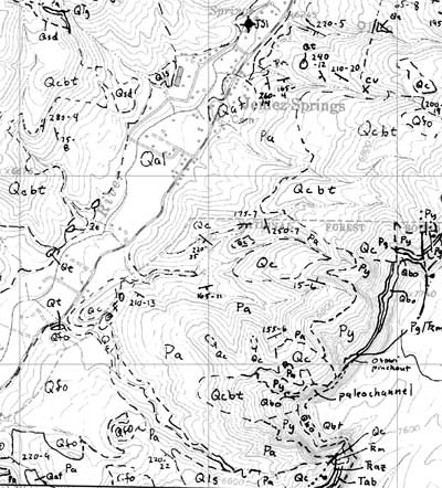
Figure 1b. Detail of geologic greenline from Figure 1a, showing the area around the village of Jemez Springs, NM (Note: on the published map, geologic linework is depicted in black and base is depicted in green). |
 |
 |
|
Figure 2a. The “second phase” version of the geologic map of the Jemez Springs quadrangle, which replaces in the Bureau’s Preliminary Map Series the draft version shown in Figure 1a. Here, the original greenline has been replaced by the ArcGIS digitized map (and displayed in color, although map units may not meet Bureau color standards). |
|
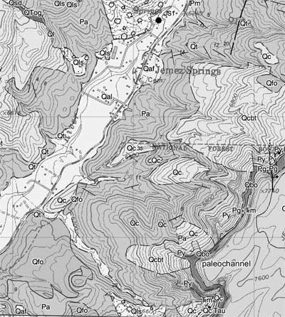
| Figure 2b. Detail of geologic map from Figure 2a, showing the area around the village of Jemez Springs, NM (for comparison, this is approximately the same area as depicted in Figure 1b). |
 |
The greenline, a digital green ink base map provided by the Bureau to the mappers both digitally and on mylar.The procedure for generating a digital greenline was described at the DMT 02 meeting, by Read, et al. (2002). The geology is inked by the compiler, and then is scanned on a Colortrac 5480 scanner to produce a 400-dpi RGB (24 bit) file. In Adobe Photoshop, the brightness and contrast are adjusted and the image is converted to the USGS standard DRG color palette (13 colors), thus greatly reducing file size and isolating the geologic linework into 1 or 2 color bins. The magic wand tool is then used to remove artifacts of the scanning process. The file then is rectified in ArcMap, and the colors are isolated into 2 bins: linework in black and base material in light green. The map then is ready for export to Adobe Acrobat, as well as for digitizing in ArcMap.
In Adobe Acrobat, the cleaned and rectified map image is combined with ancillary data files. Unit descriptions are taken directly from the report (a Microsoft Word document) and placed next to the map; the result is saved as a PDF file. Graphics (cross sections, correlation chart, location maps, etc.) are delivered from the geologists either as Adobe Illustrator files (which can go directly to the PDF file) or as drawings, etc., which are scanned and saved as PDF files in Adobe Photoshop. Photos are handled in a similar fashion. These materials then are assembled onto a 36x 50 map sheet in a draft layout, and the reduce file size command is run, resulting in a PDF file of about 3-4 MB (e.g., Figure 1a). Finally, the map is printed, submitted to the USGS as the STATEMAP contract deliverable, and uploaded to the Bureau website for public access.
Next, the map linework is digitized and attributed, the map polygons are built and attributed, and map features are labeled in ArcGIS, the second phase preliminary map is generated. In this new version of the map, the greenline scan is replaced by the ArcMap project, and a new PDF file is created (e.g., Figure 2a). Overall quality and legibility are thereby greatly enhanced, even though final cartographic production, final map layout to Bureau standards, and scientific/editorial reviews remain pending.
To expedite dissemination of new geologic mapping funded by the USGS National Cooperative Geologic Mapping Programs STATEMAP program in New Mexico, the New Mexico Bureau of Geology and Mineral Resources has developed the Preliminary Map Series. Draft geologic map data are scanned, cleaned, and rectified into a draft or preliminary map layout and are uploaded to the web when they are delivered to the USGS to fulfill the contractual obligation to the STATEMAP program. As the map progresses through digital data capture, scientific peer review, editing, and final layout commensurate with Bureau map standards, what is available to the public via the PDF file on the Bureau website is updated. Hence from Day One after contractual deadlines are met for each quadrangle, the public has access to the most current geologic map data via the Preliminary Map Series. Upon completion of all phases of map and editorial production, each quadrangle within the Preliminary Map Series is replaced and superseded by the final map in the Bureaus GM series.
Read, A.S., McCraw, D.J., and Rawling, G., 2002, New tricks for old dogs: A digital technique for producing mylar base maps for geologic mapping and compilation, in D.R. Soller, ed., Digital Mapping Techniques 02Workshop Proceedings: U.S. Geological Survey Open-file Report 02-370, p. 111-117, available at http://pubs.usgs.gov/of/2002/of02-370/read.html.

![]() U.S. Department of the Interior |
U.S. Geological Survey
U.S. Department of the Interior |
U.S. Geological Survey
URL: pubsdata.usgs.gov /pubs/of/2005/1428/mccraw/index.html
Page Contact Information: David R. Soller
Page Last Modified: Saturday, 12-Jan-2013 22:05:00 EST
