Buczkowski, Brian J. , 2006, sed_archive: Database for the U.S. Geological Survey Woods Hole Science Center's marine sediment samples, including locations, sample data and collection information: Open-File Report 2006-1187, U.S. Geological Survey, Coastal and Marine Geology Program, Woods Hole Science Center, Woods Hole, MA.This is part of the following larger work.Online Links:
- <http://pubs.usgs.gov/of/2006/1187/database/sed_archive.zip>
- <http://pubs.usgs.gov/of/2006/1187/htmldocs/data_cata.htm>
Buczkowski, Brian J. , and Kelsey, Sarah A. , 2006, Archival Policies and Collections Database for the Woods Hole Science Center's Marine Sediment Samples: Open-File Report 2006-1187, U.S. Geological Survey, Coastal and Marine Geology Program, Woods Hole Science Center, Woods Hole, MA.Online Links:
This is a Vector data set. It contains the following vector data types (SDTS terminology):
Horizontal positions are specified in geographic coordinates, that is, latitude and longitude. Latitudes are given to the nearest 0.000001. Longitudes are given to the nearest 0.000001. Latitude and longitude values are specified in Decimal degrees.
The horizontal datum used is D_WGS_1984.
The ellipsoid used is WGS_1984.
The semi-major axis of the ellipsoid used is 6378137.000000.
The flattening of the ellipsoid used is 1/298.257224.
Sequential unique whole numbers that are automatically generated.
Coordinates defining the features.
| Value | Definition |
|---|---|
| ABEL J | |
| ALBATROSS IV | |
| ALPHA & OMEGA II | |
| ALYCE C | |
| ANDERSON | |
| ANNANDALE | |
| ARGO MAINE | |
| ASTERIAS | |
| ATLANTIC SURVEYOR | |
| ATLANTIC TWIN | |
| ATLANTIS II/ALVIN | |
| ATLANTIS/ALVIN | |
| CHAPMAN | |
| CHIPPEWA | |
| CHRISTOPHER ANDREW | |
| CONNECTICUT | |
| DAVID STARR JORDAN | |
| DELAWARE II | |
| DEMPSEY | |
| DIANE G | |
| EASTWARD | |
| EDWIN LINK | |
| ELISHA KANE | |
| ELUSIVE | |
| ENDEAVOR | |
| ESTERO | |
| FARNELLA | |
| FERREL | |
| GLOMAR CONCEPTION | |
| GLORIA MICHELLE | |
| GYRE | |
| HUDSON | |
| ISABEL S | |
| JOHNSON/ JSL | |
| KAYAK | |
| KNORR | |
| LAURENTIAN | |
| LULU | |
| MARCUS HANNA | |
| MARION DUFRENSE | |
| MCARTHUR | |
| MEGAN MILLER | |
| NANCY FOSTER | |
| NEECHO | |
| NEPTUNE | |
| OCEANUS | |
| POWELL | |
| RAFAEL | |
| RITA'S RIDE | |
| ROGER B SIMONS | |
| SEAWARD EXPLORER | |
| SEWARD JOHNSON | |
| SEWARD JOHNSON/JSL | |
| TG&B MARINE MOONPOOL BOAT | |
| USCG 41 | |
| VERESHCHAGIN | |
| WADING IN WATER | |
| WHITE HEATH |
| Value | Definition |
|---|---|
| CORE | |
| DREDGE | |
| DRILL | |
| GRAB | |
| HAND SAMPLE | |
| SUBMERSIBLE SAMPLE | |
| SUSPENDED | |
| TRAP | |
| UNKNOWN | |
| WATER SAMPLE |
| Value | Definition |
|---|---|
| 1 METER PLANKTON NET | |
| ALVIN PUSH CORE | |
| BOX CORE | |
| DIGBY DREDGE | |
| DIGBY DREDGE W/ CNVS BAG | |
| DIVER OPERATED PUSH CORE | |
| DRIVE-POINT PIEZOMETER | |
| EWING PISTON CORE | |
| FLUFF SAMPLE | |
| FREE-FALL CORE | |
| GIANT PISTON CORE | |
| GRAVITY CORE | |
| GRAVITY HEAT FLOW CORE | |
| HAND SAMPLE | |
| HYDRAULICALLY DAMPED CORER w/o PISTON | |
| HYDRAULICALLY DAMPED SLOW CORE | |
| HYDROSTATIC CORE | |
| IKU GRAB | |
| NISKIN BOTTLE | |
| OTHER | |
| PIPE DREDGE | |
| PISTON CORE | |
| PONAR TYPE GRAB | |
| PUSH CORE | |
| ROCKING CHAIR DREDGE | |
| SCALLOP DERDGE | |
| SEABOSS | |
| SEDIMENT DRILL | |
| SEDIMENT TRAP | |
| SHIPEK GRAB | |
| SLIDE HAMMER CORE | |
| SMITH-MACINTYRE GRAB | |
| SMITH-MACINTYRE W/O CAMERA | |
| SURFACE GRAB | |
| SYRINGE SAMPLE FROM BOX CORE | |
| TRIGGER CORE | |
| TRIGGER-WEIGHT CORE | |
| UNKNOWN DEVICE | |
| VAN VEEN GRAB | |
| VAN VEEN GRAB - TEFLON COATED | |
| VEGEMATIC BOX CORE | |
| VIBRACORE |
| Value | Definition |
|---|---|
| APC | ALVIN PUSH CORE |
| BC | BOX CORE |
| DD | DIGBY DREDGE |
| DOP | DIVER OPERATED PUSH CORE |
| DPP | DRIVE-POINT PIEZOMETER |
| EPC | EWING PISTON CORE |
| FFC | FREE-FALL CORE |
| FS | FLUFF SAMPLE |
| GC | GRAVITY CORE |
| GHF | GRAVITY HEAT FLOW CORE |
| GPC | GIANT PISTON CORE |
| HDC | HYDRAULICALLY DAMPED SLOW CORE |
| HND | HAND SAMPLE |
| HSC | HYDROSTATIC CORE |
| IKU | IKU GRAB |
| NB | NISKIN BOTTLE |
| OTH | OTHER |
| PD | PIPE DREDGE |
| PHC | PUSH CORE |
| PTC | PISTON CORE |
| PTG | PONAR TYPE GRAB |
| RCD | ROCKING CHAIR DREDGE |
| SBC | SYRINGE SAMPLE FROM BOX CORE |
| SBS | SEABOSS |
| SCD | SCALLOP DERDGE |
| SD | SEDIMENT DRILL |
| SFG | SURFACE GRAB |
| SHC | SLIDE HAMMER CORE |
| SMG | SMITH-MACINTYRE GRAB |
| SPG | SHIPEK GRAB |
| ST | SEDIMENT TRAP |
| TC | TRIGGER CORE |
| UNK | UNKNOWN DEVICE |
| VBC | VEGEMATIC BOX CORE |
| VC | VIBRACORE |
| VV | VAN VEEN GRAB |
| Range of values | |
|---|---|
| Minimum: | 0.0 |
| Maximum: | 3280.0 |
| Range of values | |
|---|---|
| Minimum: | 0.0 |
| Maximum: | 3290.0 |
| Value | Definition |
|---|---|
| S | SAND |
| cS | CLAYEY SAND |
| mS | MUDDY SAND |
| zS | SILTY SAND |
| sC | SANDY CLAY |
| sM | SANDY MUD |
| sZ | SANDY SILT |
| C | CLAY |
| M | MUD |
| Z | SILT |
| G | GRAVEL |
| mG | MUDDY GRAVEL |
| msG | MUDDY SANDY GRAVEL |
| sG | SANDY GRAVEL |
| gM | GRAVELLY MUD |
| gmS | GRAVELLY MUDDY SAND |
| gS | GRAVELLY SAND |
| (g)M | SLIGHTLY GRAVELLY MUD |
| (g)sM | SLIGHTLY GRAVELLY SANDY MUD |
| (g)mS | SLIGHTLY GRAVELLY MUDDY SAND |
| (g)S | SLIGHTLY GRAVELLY SAND |
| Range of values | |
|---|---|
| Minimum: | 0.0 |
| Maximum: | 3970.0 |
| Range of values | |
|---|---|
| Minimum: | 0.1 |
| Maximum: | 15.24 |
| Range of values | |
|---|---|
| Minimum: | 0.0 |
| Maximum: | 5001.0 |
| Range of values | |
|---|---|
| Minimum: | 0.0 |
| Maximum: | 16407.3 |
| Value | Definition |
|---|---|
| ACKERMAN | |
| ANDREWS | |
| BOOTH | |
| BOTHNER | |
| BRATTON | |
| BUTMAN | |
| COLMAN | |
| CRUSIUS | |
| DENNY | |
| GARRISON | |
| GRASSLE | |
| HATHAWAY | |
| HOLLISTER-WHOI | |
| J BOOTH | |
| KNEBEL | |
| LEWIS | |
| M BOTHNER | |
| M TENBRINK | |
| MANHEIM | |
| POPPE | |
| RENDIGS | |
| ROBB | |
| SCANLON | |
| SCHWAB | |
| THIELER | |
| TWICHELL | |
| VALENTINE | |
| WINTERS |
| Value | Definition |
|---|---|
| YES | |
| NO |
| Value | Definition |
|---|---|
| YES | |
| NO |
| Value | Definition |
|---|---|
| YES | |
| NO |
| Value | Definition |
|---|---|
| Ambient Laboratory Van: LV01 | |
| AMCOR Refridgerated Van: RE01 | |
| Geotech Refridgerated Van: RE02 | |
| Marine Operations Facility: MOF | |
| Quissett Freezer Van: FR01 | |
| WHOI Core Storage Facility |
(508) 548-8700 x2361 (voice)
(508) 457-2310 (FAX)
bbuczkowski@usgs.gov
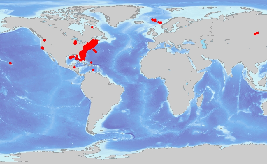
This data layer is a point coverage of sediment samples collected by the U.S. Geological Survey Woods Hole Science Center's field operations. The data contained represent collection information, as well as relationships to published materials, and storage locations. This data layer was created to build a digital mapping the sediment sampling distribution on regional, national and global scales. These data are intended for science researchers, students, and the general public. The data can be used with geographic information systems (GIS) software to display geologic and oceanographic information.
Data sources used in this process:
Accuracy of each attribute is dependant on the accuracy of the lineage data.
Locational accuracy is dependent on the accuracy of the navigational technique from the individual data sources and may vary widely (e.g., from 0.005km (differential GPS) in more recent surveys to greater than 2 km based on radar, Loran, or dead reckoning in older surveys.) Users of the data should use their own criteria for assessing the accuracy of the locations.
Locational accuracy is dependent on the accuracy of the navigational technique from the individual data sources. Users of the data should use their own criteria for assessing the accuracy of the locations.
New samples arrive at the Woods Hole Science Center regularly, and samples are being deaccessioned from the archive. The database is updated as the archive grows. Updates will be posted in version 2.
Data in the sed_archive database are derived from cruise reports, field notes, and published materials. Each source varies in type of information/data recorded and format.
Are there legal restrictions on access or use of the data?
- Access_Constraints:
- Cores and sediment samples may be examined without constraint. Sub-sampling will typically require a negotiated written agreement describing the samples to be taken, their purpose and where to contact to gain data obtained from these sub-samples.
Samples are shelved in the sample storage facility of the U.S. Geological Survey Woods Hole Science Center, 384 Woods Hole Road, Woods Hole, MA 02543. There is no legal constraint on access. Users wishing to access the cores should contact the curator to schedule a visit. Manpower to physically handle the samples and space in which to lay them out for examination are limited and are addressed on a case-by-case basis.
- Use_Constraints:
- Public domain data from the U.S. Government are freely redistributable with proper metadata and source attribution. Please recognize the U.S. Geological Survey (USGS) as the source of this information.
(508) 548-8700 x2361 (voice)
(508) 457-2310 (FAX)
bbuczkowski@usgs.gov
Downloadable Data
Although this data set has been used by the U.S. Geological Survey (USGS), no warranty, expressed or implied, is made by the USGS as to the accuracy of the data and/or related materials. The act of distribution shall not constitute any such warranty, and no responsibility is assumed by the USGS in the use of these data or related materials. Trade, firm, or product names and other references to non-USGS products and services are provided for information only and do not constitute endorsement or warranty, express or implied, by the USGS, USDOI, or U.S. Government, as to their suitability, content, usefulness, functioning, completeness, or accuracy.
| Data format: | Text file containing data and informational input into the sed_archive database. Fields are comma separated values. First record of file contains field names. in format ASCII Size: 0.429 |
|---|---|
| Network links: |
<http://pubs.usgs.gov/of/2006/1187/database/sed_archive.txt> <http://pubs.usgs.gov/of/2006/1187/htmldocs/data_cata.htm> |
These data are available in Environmental Systems Research Institute (ESRI) shapefile format. The user must have ArcGIS or ArcView 3.0 or greater software to read and process the data file. In lieu of ArcView or ArcGIS, the user may utilize another GIS application package capable of importing the data. A free data viewer, ArcExplorer, capable of displaying the data is available from ESRI at www.esri.com.
(508) 548-8700 x2361 (voice)
(508) 457-2310 (FAX)
bbuczkowski@usgs.gov