|
These lidar-derived topographic maps were
produced as a collaborative effort between the U.S. Geological Survey (USGS) Coastal and Marine Geology
Program, the National Park Service (NPS), Northeast Coastal and Barrier Network, Inventory and Monitoring Program, and the National Aeronautics and
Space Administration (NASA)
Wallops Flight Facility. The aims of the partnership that created this
product are to develop advanced survey techniques for mapping barrier
island geomorphology and habitats, and to enable the monitoring of
ecological and geological change within National Seashores. This
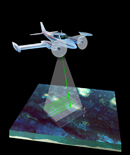
product is based on data from an innovative airborne lidar instrument
under development at the NASA Wallops Flight Facility, the NASA
Experimental Advanced Airborne Research Lidar (EAARL).
In-depth Resources
Report of the U.S.
Geological Survey
Lidar Workshop Sponsored by the Land Remote Sensing Program and held in
St. Petersburg, FL, November 2002 by Michael Crane, Tonya Clayton,
Ellen Raabe, Jason Stoker,Larry Handley, Gerald Bawden, Karen Morgan,
Vivian Queija, OFR 2004-1456,
U.S. Geological Survey - 72 pages - Adobe PDF file - 3,726 KB
|