Report Site Map > Discussion of Improving the Monitoring Network for Streamflow and Nutrient Delivery to the Gulf of Mexico
The U.S. Geological Survey (USGS), through the National Stream Quality Accounting Network (NASQAN), is evaluating potential improvements in the monitoring network for delivery of streamflow and nutrient flux to the Gulf of Mexico. Proposed improvements target two areas: improving accuracy of estimates of nutrient delivery to the Gulf of Mexico, and improving resolution of temporal variations in delivery to the Gulf of Mexico.
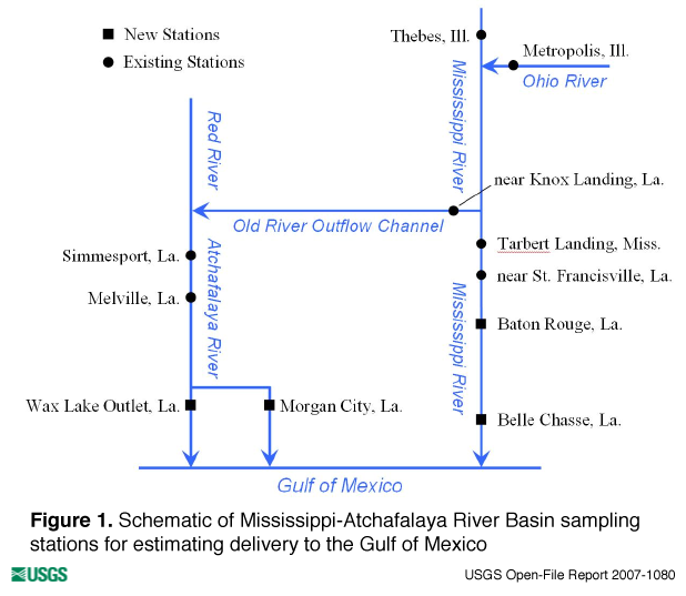 Figure 1. Schematic of Mississippi-Atchafalaya River Basin sampling stations for estimating delivery to the Gulf of Mexico |
Considering the need to collect information that more accurately describes what is delivered to the Gulf and the potential for nutrient loss or gain in the most downstream reaches of the Mississippi and Atchafalaya Rivers, additional stations currently are being monitored that are farther downstream than the existing downstream most stations. For a period of time, concurrent data will be collected at these new stations and from the current monitoring network for delivery to the Gulf of Mexico. Information and knowledge gained from the comparison of the concurrent data will be used to determine a optimum monitoring network for delivery to the Gulf.
These candidate stations are depicted in the schematic in figure 1 along with the existing monitoring stations; table 1 provides additional station information. Stations at Baton Rouge and Belle Chasse, Louisiana, now are being monitored on the main stem Mississippi River, and the stations at the Lower Atchafalaya River at Morgan City, Louisiana, and at Wax Lake Outlet now are being monitored on the Atchafalaya River. Water-quality and streamflow measurements at Baton Rouge provide the ability to estimate delivery approximately 35 river miles farther downstream on the main stem of the Mississippi River than the current station near St. Francisville. Water-quality measurements at Belle Chasse with streamflow at Baton Rouge provide the ability to estimate delivery approximately 190 river miles farther downstream on the main stem of the Mississippi River than the current station near St. Francisville. Water-quality and streamflow measurements at both the Morgan City and Wax Lake Outlet stations are located approximately 80 river miles farther downstream than the station at Melville and provide the ability to include a significant portion of the Atchafalaya River drainage.
| Station Name | Station ID | Data Type | Source |
|---|---|---|---|
| Mississippi River at Baton Rouge, La. | 07374000 | quality and flow | USGS |
| Mississippi River at Belle Chasse, La. | 07374525 | quality | USGS |
| Lower Atchafalaya River at Morgan City, La. | 07381600 | quality and flow | USGS |
| Wax Lake Outlet at Calumet, La. | 07381590 | quality and flow | USGS |
Considering the need to collect information on nutrient delivery to the Gulf of Mexico that better defines the temporal relation between nutrient delivery and the development, extent, and duration of the hypoxic zone in the northern Gulf of Mexico (Discussion of Streamflow and Nutrient Delivery to the Gulf of Mexico), the USGS has worked with partners to implement real-time measurement of both streamflow and nitrate concentration at selected downstream stations. Real-time streamflow is calculated using results of real-time velocity meters; nitrate is estimated using real-time nitrate monitors. As a result it is possible to calculate real-time nitrate flux at stations with both capabilities.
Currently, real-time velocity meters and nitrate monitors are in place at Baton Rouge, Morgan City, and Wax Lake Outlet. A real-time velocity meter was installed at Baton Rouge through a cooperative agreement with the University of Louisiana at Lafayette. Real-time nitrate monitors have been installed at Baton Rouge and Wax Lake Outlet with support from the National Oceanic and Atmospheric Administration. Operation of a nitrate monitor at Morgan City is being supported by the U.S. Environmental Protection Agency. Also, real-time velocity meters at Wax Lake Outlet and Morgan City are being supported by the U.S. Army Corps of Engineers.
Currently, the temporal resolution of flux estimates required to establish existing cause-and-effect linkages between the timing and magnitude of delivery of nutrients to the Gulf and Gulf hypoxia is unclear. There are different alternatives for implementing monitoring with increased temporal resolution. Real-time instrumentation provides the best temporal resolution, however the coverage of different nutrient species remains limited. Increasing sampling frequency provides sufficient coverage of nutrient species but is expensive because of both the cost of frequent site visits and laboratory analyses. It is likely that the monitoring design that achieves needed temporal resolution of nutrient flux will include some combination of both real-time monitors and hydrologic-based higher frequency sampling. The appropriate temporal resolution remains to be determined by continued and increased joint investigation by scientists involved in studying the delivery of nutrients from the landscape and the processes and factors affecting nutrient processing and hypoxia in the Gulf.
Report Site Map > Discussion of Improving the Monitoring Network for Streamflow and Nutrient Delivery to the Gulf of Mexico

![]() U.S. Department of the Interior |
U.S. Geological Survey
U.S. Department of the Interior |
U.S. Geological Survey
URL: http://pubsdata.usgs.gov/pubs/of/2007/1080/of-2007-1080/discussion_net_improve.html
Page Contact Information: GS Pubs Web Contact
Page Last Modified: Wednesday, 05-Mar-2025 14:48:59 EST
