Open-File Report 2007-1150
Sidescan-Sonar Imagery, Multibeam Bathymetry, and Surficial Geologic Interpretations of the Sea Floor in Rhode Island Sound, off Sakonnet Point, Rhode Island
|
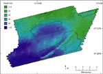
The bathymetry in the study area consists of basins and ridges with an overall southerly slope (fig. 6). A rounded central basin reaches a depth of about 31 m, while the deepest area is in the southwestern corner of the survey and reaches depths of about 36 m. The basins are surrounded by ridges, with up to 8 m of relief, which coincide with exposures of glacial drift including glaciolacustrine sediments and moraine deposits in the south (O'Hara and Oldale, 1980). Ridges tend to be covered with sand waves, a channel-eroded morphology, or composed of tabular erosional outliers, while the basins tend to have a smooth sea floor with boulders, which are present throughout much of the study area. In the southeast, ridges composed of moraine deposits are oriented northeast-southwest. |
|

![]() U.S. Department of the Interior |
U.S. Geological Survey
U.S. Department of the Interior |
U.S. Geological Survey
URL: http://pubsdata.usgs.gov/pubs/of/2007/1150/html/bathy.html
Page Contact Information: GS Pubs Web Contact
Page Last Modified: Friday, 24-Jan-2025 12:43:31 EST