
Open-File Report 2007-1150
Sidescan-Sonar Imagery, Multibeam Bathymetry, and Surficial Geologic Interpretations of the Sea Floor in Rhode Island Sound, off Sakonnet Point, Rhode Island
![]() Title |
Introduction |
Geologic Setting |
Data Acquisition/Processing |
Bathymetry |
Sidescan-Sonar Imagery |
Environments |
Discussion |
Summary |
GIS Data Catalog |
Acknowledgments |
References |
Figures |
Contacts
Title |
Introduction |
Geologic Setting |
Data Acquisition/Processing |
Bathymetry |
Sidescan-Sonar Imagery |
Environments |
Discussion |
Summary |
GIS Data Catalog |
Acknowledgments |
References |
Figures |
Contacts
 |
||
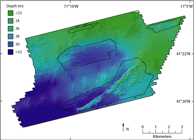
Figure 6. Hill-shaded bathymetry of the study area. Four areas outlined in black show multibeam bathymetry from H11320, while the rest of the bathymetry is from the NGDC Coastal Relief Model. Multibeam bathymetric data have been gridded at 4 m and depths represent mean lower low water level in multibeam data and either mean low water or mean lower low water in Coastal Relief Model data (Divins and Metzger). | ||

![]() U.S. Department of the Interior |
U.S. Geological Survey
U.S. Department of the Interior |
U.S. Geological Survey
URL: http://pubsdata.usgs.gov/pubs/of/2007/1150/html/fig6.html
Page Contact Information: GS Pubs Web Contact
Page Last Modified: Friday, 24-Jan-2025 12:54:08 EST

