
Open-File Report 2007-1150
Sidescan-Sonar Imagery, Multibeam Bathymetry, and Surficial Geologic Interpretations of the Sea Floor in Rhode Island Sound, off Sakonnet Point, Rhode Island
![]() Title |
Introduction |
Geologic Setting |
Data Acquisition/Processing |
Bathymetry |
Sidescan-Sonar Imagery |
Environments |
Discussion |
Summary |
GIS Data Catalog |
Acknowledgments |
References |
Figures |
Contacts
Title |
Introduction |
Geologic Setting |
Data Acquisition/Processing |
Bathymetry |
Sidescan-Sonar Imagery |
Environments |
Discussion |
Summary |
GIS Data Catalog |
Acknowledgments |
References |
Figures |
Contacts
 |
||
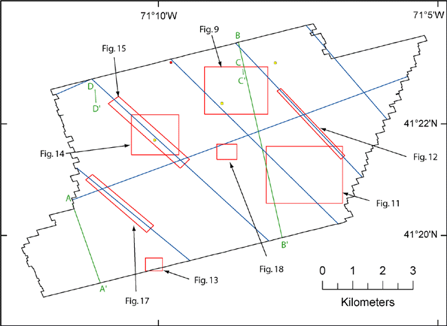
Figure 2. Location of figures (red polygons), bathymetric profiles (green lines), historic seismic-reflection profiles (blue lines, O'Hara and Oldale, 1980), and sand (yellow circles) and rocky (red circle) sediment samples (Poppe and others, 2003) within the study area. | ||

![]() U.S. Department of the Interior |
U.S. Geological Survey
U.S. Department of the Interior |
U.S. Geological Survey
URL: http://pubsdata.usgs.gov/pubs/of/2007/1150/html/fig2.html
Page Contact Information: GS Pubs Web Contact
Page Last Modified: Friday, 24-Jan-2025 12:53:07 EST

