Southwest Biological Science Center
Prepared for the Bureau of Reclamation, Upper Colorado River Region
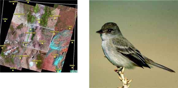
The Southwestern Willow Flycatcher (Empidonax traillii extimus; hereafter SWFL) is a federally endangered bird (USFWS 1995) that breeds in riparian areas in portions of New Mexico, Arizona, southwestern Colorado, extreme southern Utah and Nevada, and southern California (USFWS 2002). Across this range, it uses a variety of plant species as nesting/breeding habitat, but in all cases prefers sites with dense vegetation, high canopy, and proximity to surface water or saturated soils (Sogge and Marshall 2000). As of 2005, the known rangewide breeding population of SWFLs was roughly 1,214 territories, with approximately 393 territories distributed among 36 sites in New Mexico (Durst et al. 2006), primarily along the Rio Grande.
One of the key challenges facing the management and conservation of the Southwestern Willow Flycatcher is that riparian areas are dynamic, with individual habitat patches subject to cycles of creation, growth, and loss due to drought, flooding, fire, and other disturbances. Former breeding patches can lose suitability, and new habitat can develop within a matter of only a few years, especially in reservoir drawdown zones. Therefore, measuring and predicting flycatcher habitat - either to discover areas that might support SWFLs, or to identify areas that may develop into appropriate habitat - requires knowledge of recent/current habitat conditions and an understanding of the factors that determine flycatcher use of riparian breeding sites.
In the past, much of the determination of whether a riparian site is likely to support breeding flycatchers has been based on qualitative criteria (e.g., dense vegetation or large patches). These determinations often require on-the-ground field evaluations by local or regional SWFL experts. While this has proven valuable in locating many of the currently known breeding sites, it is difficult or impossible to apply this approach effectively over large geographic areas (e.g., the middle Rio Grande). The SWFL Recovery Plan (USFWS 2002) recognizes the importance of developing new approaches to habitat identification, and recommends the development of drainage-scale, quantitative habitat models. In particular, the plan suggests using models based on remote sensing and Geographic Information System (GIS) technology that can capture the relatively dynamic habitat changes that occur in southwestern riparian systems.
In 1999, Arizona Game and Fish Department (AGFD) developed a GIS-based model (Hatten and Paradzick 2003) to identify SWFL breeding habitat from Landsat Thematic Mapper™ imagery and 30-m resolution digital elevation models (DEMs). The model was developed with presence/absence survey data acquired along the San Pedro and Gila rivers, and from the Salt River and Tonto Creek inlets to Roosevelt Lake in southern Arizona (collectively called the project area). The GIS-based model used a logistic regression equation to divide riparian vegetation into 5 probability classes based upon characteristics of riparian vegetation and floodplain size. This model was tested by predicting SWFL breeding habitat at Alamo Lake, Arizona, located 200 km from the project area (Hatten and Paradzick 2003). The GIS-based model performed as expected by identifying riparian areas with the highest SWFL nest densities, located in the higher probability classes.
In 2002, AGFD applied the GIS-based model throughout Arizona, for riparian areas below 1,524 m (5,000 ft) elevation and within 1.6 km of perennial or intermittent waters (Dockens et al. 2004). Overall model accuracy (using probability classes 1-5, with class 5 having the greatest probability of nesting activity) for predicting the location of 2001 nest sites was 96.5%; accuracy decreased when fewer probability classes were defined as suitable. Map accuracy, determined from errors of commission, increased in higher probability classes in a fashion similar to errors of omission. Map accuracy, like model accuracy, was dependent on what probability cutpoint was selected. A cutpoint, or probability threshold, is a modeler-selected value at which suitable (i.e., high probability) habitat is dichotomously distinguished from unsuitable (i.e., low probability) habitat. For the Hatten and Paradzick (2003) model, the lower the cutpoint used, the greater the amount of predicted habitat and model sensitivity, but the lower its specificity. Inversely, as the cutpoint increased, the models specificity increased, but the amount of predicted habitat and the sensitivity decreased. To explain the effect of cutpoint choice, Hatten and Paradzick (2003) concluded that if all class-5 cells (the 80% cutpoint) had been surveyed in Arizona during 2001, approximately 20% would have been unsuitable for SWFLs and roughly 30% of SWFL nests would have been missed. If surveyors had searched all class 3-5 cells (representing the 40% cutpoint), 32% would not have been breeding habitat, and <5% of nests would have been missed. This is an issue inherent with all models of this kind, and there is no perfect cutpoint. The Hatten and Paradzick (2003) model was clearly successful at predicting flycatcher breeding sites in Arizona based on remote sensing data and GIS-based themes.
This is the first large-scale predictive model of its kind for SWFL habitat. It focused on low to mid-elevation breeding sites because there were relatively few high elevation sites or territories in Arizona. Based upon the models robust performances in Arizona, we believed that it could be applied elsewhere within the species range. Because New Mexico has a relatively large SWFL breeding population, with intensive survey and nest monitoring of major sites along the Rio Grande (Ahlers and Moore 2004), it provided a good opportunity to evaluate the models performance outside of Arizona. We hypothesized that if the model was applied to the Rio Grande, the 5 probability classes output by the model would contain either a linear, exponential, or binary relationship with SWFL nest or territory density. Because the model outputs georeferenced layers that can be queried and viewed with a GIS, the model can be used as a decision support system for prioritizing breeding site and nest surveys, or identifying potential restoration or enhancement locations. In doing so, users would need to carefully consider the effect of cutpoint choice and the amount of predicted habitat.
An extensive compilation of information on this topic is available at the Web site on Southwestern Willow Flycatcher Reports.
For questions about the content of this report, contact James Hatten
Suggested citation and version history
Download a copy of the latest version of Adobe Reader for free.
|
Help |
PDF help |
Publications main page |
| Western Open-File Reports for 2007 |
| Biological Resources |
Southwest Biological Science Center
|

![]() U.S. Department of the Interior | U.S. Geological Survey
U.S. Department of the Interior | U.S. Geological Survey
URL: https://pubs.usgs.gov/of/2007/1207/
Page Contact Information: Michael Diggles
Page Last Modified: October 15, 2007 (mfd)