
Open-File Report 2007-1366
Sidescan-Sonar Imagery and Surficial Geologic Interpretations of the Sea Floor in Central Rhode Island Sound
![]() Title |
Introduction |
Geologic Setting |
Data Acquisition/Processing |
Bathymetry |
Seismic Reflection Data |
Sidescan Sonar Imagery |
Environments |
Discussion |
Summary |
GIS Data Catalog |
Acknowledgments |
References |
Figures |
Contacts
Title |
Introduction |
Geologic Setting |
Data Acquisition/Processing |
Bathymetry |
Seismic Reflection Data |
Sidescan Sonar Imagery |
Environments |
Discussion |
Summary |
GIS Data Catalog |
Acknowledgments |
References |
Figures |
Contacts
 |
||
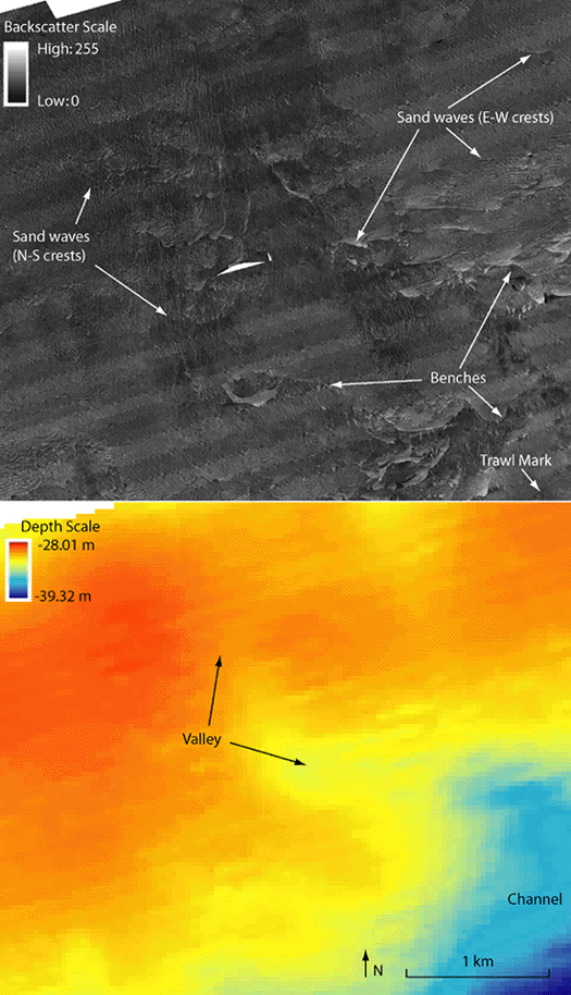
Figure 11. Detailed sidescan-sonar and bathymetry images of sand waves along a channel on the northern ridge. Sand waves adjacent to the channel are straight-crested and oriented north-south; away from the channel sand waves have more curved and sinuous crests that are oriented east-west. In the channel in the central part of the image, both east-west and north-south oriented sand waves are present, suggesting complex flow and transport directions. Benches are also visible on the sidescan-sonar image where there is a sharp curvilinear change in backscatter. A trawl mark is visible in the southeastern corner of the sidescan-sonar image. Light and dark bands oriented northeast-southwest are artifacts in the sidescan sonar. Location of figure shown in fig. 2. | ||

![]() U.S. Department of the Interior |
U.S. Geological Survey
U.S. Department of the Interior |
U.S. Geological Survey
URL: http://pubsdata.usgs.gov/pubs/of/2007/1366/html/fig11.html
Page Contact Information: GS Pubs Web Contact
Page Last Modified: Thursday, 05-Dec-2024 15:12:44 EST

