
Open-File Report 2007-1366
Sidescan-Sonar Imagery and Surficial Geologic Interpretations of the Sea Floor in Central Rhode Island Sound
![]() Title |
Introduction |
Geologic Setting |
Data Acquisition/Processing |
Bathymetry |
Seismic Reflection Data |
Sidescan Sonar Imagery |
Environments |
Discussion |
Summary |
GIS Data Catalog |
Acknowledgments |
References |
Figures |
Contacts
Title |
Introduction |
Geologic Setting |
Data Acquisition/Processing |
Bathymetry |
Seismic Reflection Data |
Sidescan Sonar Imagery |
Environments |
Discussion |
Summary |
GIS Data Catalog |
Acknowledgments |
References |
Figures |
Contacts
 |
||
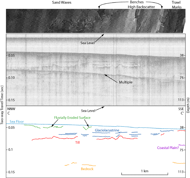
Figure 8. Seismic-reflection profile across western end of study area from Needell and others (1983a) with interpretation and corresponding sidescan-sonar image. Interpretation includes: Paleozoic bedrock, possible Cretaceous coastal plain sediments, Wisconsin glacial till and glaciolacustrine sediments, and Holocene marine and transitional deposits. Sidescan-sonar image shows sand waves in the north and benches, high backscatter, and trawl marks in the south. Benches occur at the contact between fluvial and glaciolacustrine sediments and within the glaciolacustrine sediment near the exposure of till. Depths are based on an assumed compressional wave velocity of 1500 m/s. Vertical exaggeration: 13X. Location of profile shown in fig. 2. | ||

![]() U.S. Department of the Interior |
U.S. Geological Survey
U.S. Department of the Interior |
U.S. Geological Survey
URL: http://pubsdata.usgs.gov/pubs/of/2007/1366/html/fig8.html
Page Contact Information: GS Pubs Web Contact
Page Last Modified: Thursday, 05-Dec-2024 14:27:53 EST

