Geophysical Unit of Menlo Park, Calif.
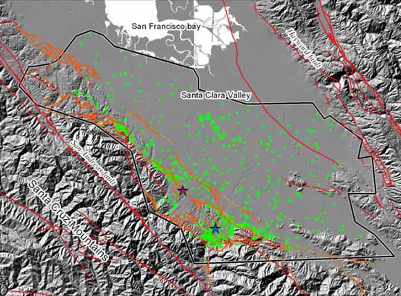
Study area for damage data. Major faults systems are labeled. Green dots are sites of observed damage from the Loma Prieta earthquake. Blue star is the approximate location of the town of Los Gatos, purple star is the approximate location of the town of Saratoga. Los Gatos embayment is the concavity in the range front that encompasses these two towns (from figure 2).
This report describes some simple spatial statistical methods to explore the relationships of scattered points to geologic or other features, represented by points, lines, or areas. It also describes statistical methods to search for linear trends and clustered patterns within the scattered point data. Scattered points are often contained within irregularly shaped study areas, necessitating the use of methods largely unexplored in the point pattern literature. The methods take advantage of the power of modern GIS toolkits to numerically approximate the null hypothesis of randomly located data within an irregular study area. Observed distributions can then be compared with the null distribution of a set of randomly located points. The methods are non-parametric and are applicable to irregularly shaped study areas. Patterns within the point data are examined by comparing the distribution of the orientation of the set of vectors defined by each pair of points within the data with the equivalent distribution for a random set of points within the study area. A simple model is proposed to describe linear or clustered structure within scattered data.
A scattered data set of damage to pavement and pipes, recorded after the 1989 Loma Prieta earthquake, is used as an example to demonstrate the analytical techniques. The damage is found to be preferentially located nearer a set of mapped lineaments than randomly scattered damage, suggesting range-front faulting along the base of the Santa Cruz Mountains is related to both the earthquake damage and the mapped lineaments. The damage also exhibit two non-random patterns: a single cluster of damage centered in the town of Los Gatos, California, and a linear alignment of damage along the range front of the Santa Cruz Mountains, California. The linear alignment of damage is strongest between 45° and 50° northwest. This agrees well with the mean trend of the mapped lineaments, measured as 49° northwest.
Download this report as a 51-page PDF file (of2007-1442.pdf; 3.8 MB).
For questions about the content of this report, contact Geoff Phelps
Suggested citation and version history
Download a free copy of the latest version of Adobe Reader.
|
Help |
PDF help |
Publications main page |
| Western Open-File Reports for 2007 |
| Geologic Division |
Geophysical Unit of Menlo Park, Calif. (GUMP)
|

![]() U.S. Department of the Interior | U.S. Geological Survey
U.S. Department of the Interior | U.S. Geological Survey
URL: https://pubs.usgs.gov/of/2007/1442/
Page Contact Information: Michael Diggles
Page Last Modified: January 23, 2008