Open-File Report 2008-1181
![]() Title |
Introduction |
Geologic Setting |
Data Acquisition/Processing |
Bathymetry |
Seismic-Reflection Data |
Sidescan-Sonar Imagery |
Environments |
Sea-Floor Geology |
Summary |
GIS Data Catalog |
Acknowledgments |
References Cited |
Figures |
Contacts
Title |
Introduction |
Geologic Setting |
Data Acquisition/Processing |
Bathymetry |
Seismic-Reflection Data |
Sidescan-Sonar Imagery |
Environments |
Sea-Floor Geology |
Summary |
GIS Data Catalog |
Acknowledgments |
References Cited |
Figures |
Contacts
 |
||
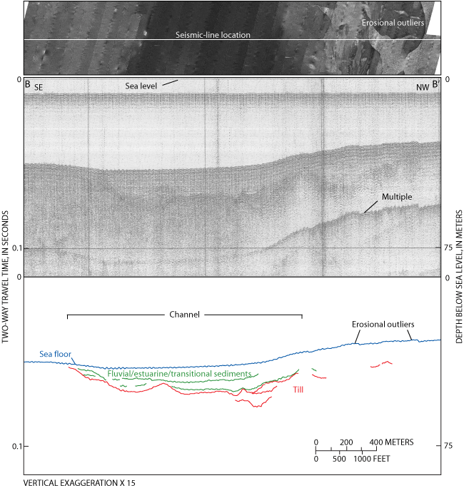
Figure 7. (Top) sidescan-sonar imagery from the western part of the study area, (middle) in the area of seismic-reflection profile B-B' (from Needell and others, 1983b) extending southeast to northwest, (bottom) with interpretation. Fluvial, estuarine, and transitional sediments overlie till in the channel and along the southern flank of the northwestern bathymetric high. The bathymetric high also shows small plateaus, which are visible as patches of high and low backscatter in the sidescan-sonar imagery and are interpreted to be erosional outliers. Location of seismic-reflection profile is shown in figure 6. | ||

![]() U.S. Department of the Interior |
U.S. Geological Survey
U.S. Department of the Interior |
U.S. Geological Survey
URL: http://pubsdata.usgs.gov/pubs/of/2008/1181/html/fig7.html
Page Contact Information: GS Pubs Web Contact
Page Last Modified: Friday, 26-Aug-2022 08:34:20 EDT
