

|
|
Coastal and Marine Geology Program
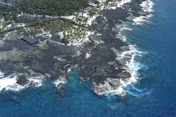
Oblique aerial photograph showing Pu‘uhonua Point and the adjacent Pu‘uhonua O Hōnaunau National Historical Park coast. The basalt platform, which extends along the coast between the waters edge and the white sand of the perched beaches, is mostly devoid of sediment cover. Photograph courtesy of Brian Powers, Hawaiian Images Photography and Video, Kailua Kona, Hawai‘i.
Geologic resource inventories of lands managed by the National Park Service (NPS) are important products for the parks and are designed to provide scientific information to better manage park resources. Park-specific geologic reports are used to identify geologic features and processes that are relevant to park ecosystems, evaluate the impact of human activities on geologic features and processes, identify geologic research and monitoring needs, and enhance opportunities for education and interpretation. These geologic reports are planned to provide a brief geologic history of the park and address specific geologic issues forming a link between the park geology and the resource manager.
The Kona coast National Parks of the Island of Hawai‘i are intended to preserve the natural beauty of the Kona coast and protect significant ancient structures and artifacts of the native Hawaiians. Pu‘ukoholā Heiau National Historic Site (PUHE), Kaloko-Honokōhau National Historical Park (KAHO), and Pu‘uhonua O Hōnaunau National Historical Park (PUHO) are three Kona parks studied by the U.S. Geological Survey (USGS) Coastal and Marine Geology Team in cooperation with the National Park Service. This report is one of six related reports designed to provide geologic and benthic-habitat information for the three Kona parks. Each geology and coastal-landform report describes the regional geologic setting of the Hawaiian Islands, gives a general description of the geology of the Kona coast, and presents the geologic setting and issues for one of the parks. The related benthic-habitat mapping reports discuss the marine data and habitat classification scheme, and present results of the mapping program.
Pu‘uhonua O Hōnaunau National Historical Park (“Place of Refuge of Hōnaunau”) is the southernmost of the three National Parks located on the leeward Kona coast of the Island of Hawai‘i. It is a relatively small park originally 73 ha (182 acres), and was expanded in 2006 with the acquisition of an additional 96 ha (238 acres). The park is probably best known for the pu‘uhonua (place of refuge) native Hawaiian cultural site. In addition to the pu‘uhonua, the park contains palace grounds, royal fishponds, burial sites, prehistoric trails, a royal canoe landing area, stone house platforms and associated temple structures. A massive basalt rock wall (300 m long, 3 m high, and 5 m wide) separates the pu‘uhonua from the areas used by Hawaiian royalty and other grounds. Hōnaunau Bay is a popular marine resource area adjacent to the park.
The seaward-sloping lands of PUHO lie at the base of Mauna Loa volcano, which forms a bench of low-lying pahoehoe lava flows at Pu‘uhonua Point. The park coastline is approximately 1.6 km long and is mostly rocky with the exception of a small artificially nourished beach at Keone‘ele Cove at the northern boundary next to Hōnaunau Bay. The park is bounded to the south by Ki‘ilae Bay and includes the coastal portions of three Hawaiian land divisions (ahupua‘a): Hōnaunau, Kēōkea, and Ki‘ilae. The western boundary is the high tide mark. The waters of Keone‘ele Cove, the ancient royal canoe landing at PUHO, while not formally under NPS jurisdiction, are managed by the park under an agreement with the State of Hawai‘i. This small embayment is a known haven for sea turtles, which are often found sunning themselves on the nearshore volcanic platform. Impacts to this area include frequent visits by scuba divers and snorkelers to Hōnaunau Bay and a small boat ramp located just to the north of Keone‘ele Cove.
There is an accompanying report that presents the results of benthic habitat mapping of the offshore waters for PUHO (Cochran and others, 2006b; linked below). They mapped from the shoreline to depths of approximately 40 m, where the shelf drops off to a sand-covered bottom. PUHO park boundaries extend only to the mean high-tide level; however, landscape impacts created by development around the park are of concern to Park management.
Download this report as a 30-page PDF file (of2008-1192.pdf; 12.3 MB).
USGS Scientific Investigations Report 2006-5258, Geologic Resource Evaluation of Pu‘uhonua O Hōnaunau National Historical Park, Hawai‘i; Part II: Benthic Habitat Mapping by Susan A. Cochran, Ann E. Gibbs, and Joshua B. Logan
For questions about the content of this report, contact Bruce Richmond
Download a free copy of the latest version of Adobe Reader.
|
Help |
PDF help |
Publications main page |
| Western Open-File Reports for 2008 |
| Geography | Coastal and Marine Geology
|

![]() U.S. Department of the Interior | U.S. Geological Survey
U.S. Department of the Interior | U.S. Geological Survey
URL: https://pubs.usgs.gov/of/2008/1192/
Page Contact Information: Michael Diggles
Page Created: February 17, 2009
Page Last Modified: February 18, 2009