

|
|
Coastal and Marine Geology Program
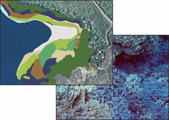
Left, enlarged portion of benthic habitat map showing Hōnaunau Bay and Pu‘uhonua O Hōnaunau National Historical Park shoreline. Right, underwater photograph shows example of coral reef habitat on the Kona coast of Hawai‘i.
In cooperation with the U.S. National Park Service (NPS), the U.S. Geological Survey (USGS) has mapped the underwater environment in and adjacent to three parks along the Kona coast on the island of Hawai‘i. This report is the second of two produced for the NPS on the geologic resource evaluation of of Pu‘uhonua O Hōnaunau National Historical Park (PUHO) and presents the results of benthic habitat mapping of the offshore waters for PUHO. See Part I (Richmond and others, 2006) for an overview of the regional geology, local volcanics, and a detailed description of coastal landforms in the park.
Pu‘uhonua O Hōnaunau National Historical Park boundaries extend only to the mean high tide line and do not officially include the marine environment. However, impacts downslope of any development in the park are of concern to management. The area mapped for this report extends from Hōnaunau Bay, around Pu‘uhonua Point, to Ki‘ilae Bay and the south park boundary and from the shoreline to depths of approximately 40 m (130 ft), where the shelf drops off to a sand-covered bottom.
Pu‘uhonua O Hōnaunau National Historical Park lies within the nearly 850-km2 Ki‘ilae watershed, which begins at the crest of Mauna Loa. The Ki‘ilae Watercourse runs through the southern area of the park and empties into Ki‘ilae Bay, but only during periods of extreme rainfall.
The waters of Keone‘ele Cove, the ancient royal canoe landing at PUHO, while not formally under NPS jurisdiction, are managed by the park under an agreement with the State of Hawaii. This small embayment is a known haven for sea turtles, which are often found sunning themselves on the near- shore volcanic platform. Impacts to this area include frequent visits by scuba divers and snorkelers to Hōnaunau Bay and a small boat ramp located just to the north of Keone‘ele Cove.
Download this report as a 26-page PDF file (sir2006-5258.pdf; 3.7 MB).
Read the metadata for the GIS data linked below. (PUHO_BenthicHabitats_meta.htm; 40 kB).
Download the GIS data for this report as a compressed file. This file includes the shapefile and associated metadata files for the benthic habitat map (PUHO_bhabs.zip; 88 kB).
USGS Open-File Report 2008-1192, Geologic Resource Evaluation of Pu‘uhonua O Hōnaunau National Historical Park, Hawai‘i; Part I: Geology and Coastal Landforms by Bruce M. Richmond, Susan A. Cochran, and Ann E. Gibbs
For questions about the content of this report, contact Susan Cochran
Suggested citation and version history
Download a copy of the latest version of Adobe Reader for free.
|
Help |
PDF help |
Publications main page |
| Western Scientific Investigations Reports |
| Geography | Coastal and Marine Geology
|

![]() U.S. Department of the Interior | U.S. Geological Survey
U.S. Department of the Interior | U.S. Geological Survey
URL: https://pubs.usgs.gov/sir/2006/5258/
Page Contact Information: Michael Diggles
Page Created: April 17, 2007
Page Last Modified: February 18, 2009