U.S. Geological Survey Open-File Report 2008-1206
Coastal Change Along the Shore of Northeastern South Carolina: The South Carolina Coastal Erosion Study
Return to: Title and Abstract » Table of Contents » Section 1 » Section 2 » Section 3 » Section 4 » Section 5 » Section 6 » Acknowledgments » References » List of Figures » Acronymns » Glossary |
Box #3: Lines in the SandThe South Carolina Beachfront Management Act (SCBMA) is designed to protect coastal resources while also promoting responsible development in the State's coastal zone. The SCBMA was adopted in 1988 and established a jurisdictional baseline typically placed at the crest of the primary dune, if present. The SCBMA called for developers to locate new construction at a minimum distance landward of the baseline. This minimum distance, delineated by the setback line, is established where the baseline is calculated to be in 40 years (that is, a distance equal to 40 times the annual erosion rate). The annual erosion rate is determined from analysis of aerial photographs and beach profiles. Because the rate of erosion varies along the coast, the distance to the setback line is not the same for every section of beach. Also under the SCBMA, no new seawall construction is allowed but older erosion-control structures can be maintained. If an existing structure is heavily damaged or destroyed, however, it must be removed by the owner. Specific provisions include:
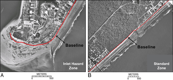
Inlet systems locally complicate pathways of sand movement, and beaches adjacent to inlets are particularly dynamic. As a result, the SCBMA classified sections of the coast as “standard zones” and “inlet hazard zones” (see examples below). Standard zones are those areas away from the influence of inlets; these zones are defined by having shore-parallel depth contours. In standard zones, the baseline is defined as the crest of the primary dune identified by beach surveys. Inlet hazard zones are those areas adjacent to tidal inlets where depth contours are oblique to the coast due to the influence of inlet-associated shoals and nearshore sand bars. In inlet hazard zones, the baseline is defined by the most landward position of the shoreline in the previous 40 years as identified from aerial photographs. |
||
|
||
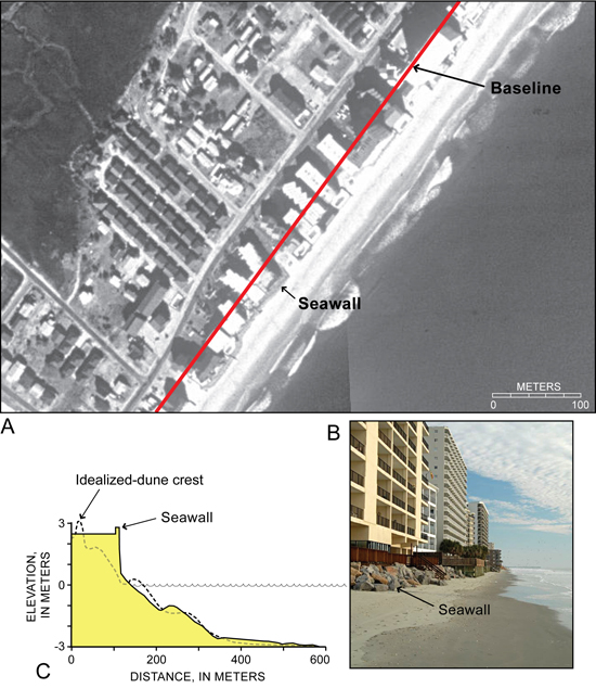
The SCBMA also recognized that engineering structures, where they exist, strongly modify beach processes and behavior. As a result, standard zones are further divided into “natural” and “armored” areas. For armored areas, the primary dune crest no longer exists as a marker to determine the baseline. Instead, an idealized-dune crest is projected landward of the shore-protection structure on an equivalent-volume basis (see example below). Inlet hazard zones are similarly divided into “stabilized” and “unstabilized” areas. In the vicinity of jetties and other structures, profiles from adjacent nonengineered beaches are used to project the baseline along the coast. |
||
|

 U.S. Department of the Interior |
U.S. Geological Survey
U.S. Department of the Interior |
U.S. Geological Survey
[an error occurred while processing this directive]
URL: https://pubsdata.usgs.gov
Page Contact Information: Publishing Service Center
Page Last Modified: Wednesday, 07-Dec-2016 21:39:13 EST