U.S. Geological Survey Open-File Report 2008-1206
Coastal Change Along the Shore of Northeastern South Carolina: The South Carolina Coastal Erosion Study
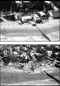
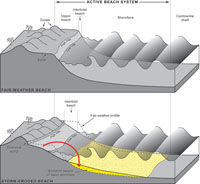
1.1 IntroductionCoastal and nearshore marine environments are dynamic natural systems that continually evolve or change over time. In the United States, barrier islands that protect most of the Atlantic and Gulf Coasts have, on the whole, moved landward over many centuries. To a geologist or oceanographer, the landward migration is a natural response to storms, sea-level rise, and other processes that operate at the ocean's edge. To an owner of beachfront property, however, this coastal change is simply erosion. By identifying the agents responsible for coastal change and determining the relative contribution of each agent, scientists and policy makers can address the underlying causes of beach erosion, wetland loss and other challenging issues. The development and application of science-based management strategies will help to conserve coastal environments while ensuring that they remain places the public can continue to safely inhabit and enjoy. Coastal change is a major concern along many segments of the world's coastlines. Rapid population growth over recent decades has increased pressure on what remains of natural coastal environments. More than half the United States population lives in coastal counties, which account for only 17 percent of the land area of the nation (Beach, 2002). Most of these coastal areas are actively eroding or are otherwise vulnerable to rising sea level (Dolan and others, 1985; Thieler and Hammar-Klose, 1999, 2000a, 2000b). Human activities, such as seawall construction and channel dredging, have reduced sediment supply to beaches, interrupted the natural movement of sediment along the coast, and modified the normal flow of water through inlets and estuaries. Additionally, processes associated with storms and sea-level rise have eroded beaches and flooded low-lying areas, profoundly shifting the position of the shoreline (Figure 1.1). These processes act over different time scales to drive coastal change, which in turn threatens the infrastructure and economies of many coastal communities. An increase in the rate of sea-level rise is expected due to global warming over the next century, according to a report by the Intergovernmental Panel on Climate Change (IPCC, 2007). The best estimate from IPCC suggests that sea level will rise about 50 cm (20 inches) by the year 2100, almost twice the rate observed over the previous 100 years (Douglas, 1997). Global warming is also expected to produce higher sea-surface temperatures, which have been linked to more frequent and more powerful hurricanes (Emanuel, 2005; Webster and others, 2005). If this linkage is real, years of relatively quiet storm activity will come to an end for many coastal areas. Beach towns might face severe societal and economic upheaval such as that experienced by residents of the Gulf Coast during the active hurricane seasons of 2004–2005. In addition, the scientific community generally lacks the ability to predict these effects on time scales short enough to be used in making land-use decisions. In order to locate new construction or issue permits for other activities, for example, resource managers and policy makers need reliable information to predict when, where, and how much the coast will change. Changes in the morphology of coastal landforms and patterns of sediment movement have been studied for over a century but, in general, scientists have only a rudimentary understanding of the processes that drive coastal change. For example, we know that the shapes of sandy shorelines are largely dictated by waves, tides, and currents that act across a wide spectrum of spatial and temporal scales. Whereas a single storm can dramatically transform a section of coastline overnight, the impacts of sea-level rise take place over decades or centuries. That storm might deeply erode a beach in only a few hours, but the sediment is not necessarily lost forever. Gentle swells from prolonged periods of fair weather following the storm typically return sediment to the beach (Figure 1.2). As the frequency and intensity of storms vary each year, so too does the condition of the beach. The U.S. Geological Survey (USGS) conducts regional studies of coastal erosion to provide impartial scientific information necessary for the protection and management of valuable coastal resources. This report summarizes the results of a 7-year, multidisciplinary study of the northeastern coast of South Carolina. The main objective of the study was to determine the geologic and oceanographic processes that control sediment movement along the region's shoreline and thereby improve projections of coastal change. Next Section: 1.2 The Grand Strand » |

 U.S. Department of the Interior |
U.S. Geological Survey
U.S. Department of the Interior |
U.S. Geological Survey
[an error occurred while processing this directive]
URL: https://pubsdata.usgs.gov
Page Contact Information: Publishing Service Center
Page Last Modified: Wednesday, 07-Dec-2016 21:39:01 EST