
High-Resolution Chirp and Mini-Sparker Seismic-Reflection Data From the Southern California Continental Shelf—Gaviota to Mugu Canyon
Metadata also available as - [Questions & Answers] - [Parseable text] - [XML]
Metadata
- Identification_Information
- Data_Quality_Information
- Spatial_Data_Organization_Information
- Spatial_Reference_Information
- Distribution_Information
- Metadata_Reference_Information
- Identification_Information:
-
- Citation:
-
- Citation_Information:
-
- Originator:
- Ray W. Sliter, Peter J. Triezenberg, Patrick E. Hart, Amy E. Draut, William R. Normark, and James E. Conrad
- Publication_Date: 2008
- Title:
- High-Resolution Chirp and Mini-Sparker Seismic-Reflection Data From the Southern California Continental Shelf--Gaviota to Mugu Canyon
- Series_Information:
-
- Series_Name: U.S. Geological Survey Open-File Report
- Issue_Identification: 2008-1246
- Publication_Information:
-
- Publication_Place: Menlo Park, CA
- Publisher: U.S. Geological Survey
- Online_Linkage: <https://pubs.usgs.gov/of/2008/1246/>
- Geospatial_Data_Presentation_Form: seismic reflection profile section
- Description:
-
- Abstract:
-
This report consists of high-resolution chirp and single-channel
Sparker seismic-reflection-
profile data from the Santa Barbara Channel, California.
These data were acquired in 2007 using the Research Vessel
Zephyr2 (USGS Cruise ID: Z-3-07-SC) and the Research Vessel
Parke Snavely (USGS Cruise ID: S-7-08-SC).
The data are available in binary, TIFF and JPEG image formats.
Binary data are in Society of Exploration Geologists (SEG)
SEG-Y format and may be downloaded for further processing or display.
Reference maps and JPEG images of the profiles may be viewed
with your Web browser.
- Purpose:
-
Marine seismic reflection data are used to image and map
sedimentary and structural features of the seafloor and subsurface.
These data were acquired across the northern shelf area
of the Santa Barbara Channel, Calif.,
as part of a multiagency effort to characterize
the geologic framework and sedimentary environment of the region.
The specific objective of this seismic survey is
to provide seismic reflection images of the depositional geometry
of the upper 50 m of subbottom stratigraphy
in order to better understand the mechanisms
of sediment transport and deposition.
These seismic profiles provide high-quality images
with approximately 20 cm of vertical resolution and
up to 80 m of subbottom penetration.
- Supplemental_Information:
-
Chirp seismic-reflection profiles are acquired by means
of an acoustic source and a hydrophone array, both contained
in a single unit towed in the water behind a survey vessel
approximately 4 meters below the water surface.
The sound source emits a short (30 ms) swept-frequency
(500 to 7,200 Hz) acoustic pulse, which propagates through
the water and sediment columns.
The acoustic energy is reflected at density boundaries
(such as the sea floor or sediment layers beneath the sea floor),
and detected by the hydrophone array, and
digitally recorded by the onboard PC-based acquisition system.
As the vessel moves, this process is repeated multiple times
per second, producing a two-dimensional image of the shallow
geologic structure beneath the ship track.
Mini-sparker profiles are collected with a 500 Joule sparker source and
15-m single-channel streamer towed at the sea surface and
using the same acquisition system.
Additional information about the USGS survey Z-3-07-SC is available at <http://walrus.wr.usgs.gov/infobank/z/z307sc/html/z-3-07-sc.meta.html>.
Additional information about the USGS survey S-7-08-SC is available at <http://walrus.wr.usgs.gov/infobank/s/s708sc/html/s-7-08-sc.meta.html>.
- Time_Period_of_Content:
-
- Time_Period_Information:
-
- Range_of_Dates/Times:
-
- Beginning_Date: 20070912
- Ending_Date: 20080701
- Currentness_Reference: ground condition
- Status:
-
- Progress: Complete
- Maintenance_and_Update_Frequency: None planned
- Spatial_Domain:
-
- Bounding_Coordinates:
-
- West_Bounding_Coordinate: -120.2113
- East_Bounding_Coordinate: -119.0521
- North_Bounding_Coordinate: 34.4701
- South_Bounding_Coordinate: 34.0161
- Keywords:
-
- Theme:
-
- Theme_Keyword_Thesaurus: ISO 19115 Topic Category
- Theme_Keyword: geoscientificinformation
- Theme_Keyword: oceans
- Theme:
-
- Theme_Keyword_Thesaurus: USGS CMG InfoBank
- Theme_Keyword: Marine Geology
- Theme_Keyword: Marine Geophysics
- Theme_Keyword: Marine Seismic
- Place:
-
- Place_Keyword_Thesaurus: Geographic Names Information System (GNIS)
- Place_Keyword: Santa Barbara Channel
- Place_Keyword: Mugu Canyon
- Place_Keyword: Hueneme Canyon
- Place:
-
- Place_Keyword_Thesaurus: USGS CMG InfoBank
- Place_Keyword: CA
- Place_Keyword: Channel Islands National Marine Sanctuary, CA
- Place_Keyword: Mugu Submarine Canyon
- Place_Keyword: Hueneme Submarine Canyon
- Place_Keyword: North Pacific Ocean
- Place_Keyword: Northern Pacific Ocean
- Place_Keyword: Southern California
- Place_Keyword: California State Waters
- Place_Keyword: USA
- Access_Constraints:
-
Physical materials are under controlled on-site access.
If available, access to physical samples is described in the "WR CMG Sample Distribution Policy" at: <http://walrus.wr.usgs.gov/infobank/programs/html/main/sample-dist-policy.html>
- Use_Constraints:
-
Please recognize the U.S. Geological Survey (USGS) as
the source of this information.
Physical materials are under controlled on-site access.
Some USGS information accessed through this means may be preliminary in nature and presented without the approval of the Director of the USGS. This information is provided with the understanding that it is not guaranteed to be correct or complete and conclusions drawn from such information are the responsibility of the user.
This information is not intended for navigational purposes.
Any use of trade, firm, or product names is for descriptive purposes only and does not imply endorsement by the U.S. Government.
- Point_of_Contact:
-
- Contact_Information:
-
- Contact_Organization_Primary:
-
- Contact_Organization: U.S. Geological Survey (USGS), Coastal and Marine Geology (CMG)
- Contact_Person: Ray W. Sliter
- Contact_Position: Geophysicist
- Contact_Address:
-
- Address_Type: mailing and physical address
- Address: USGS, MailStop 999, 345 Middlefield Road
- City: Menlo Park
- State_or_Province: CA
- Postal_Code: 94025-3561
- Country: USA
- Contact_Voice_Telephone: (650) 329-5194
- Contact_Facsimile_Telephone: (650) 329-5190
- Contact_Electronic_Mail_Address: rsliter@usgs.gov
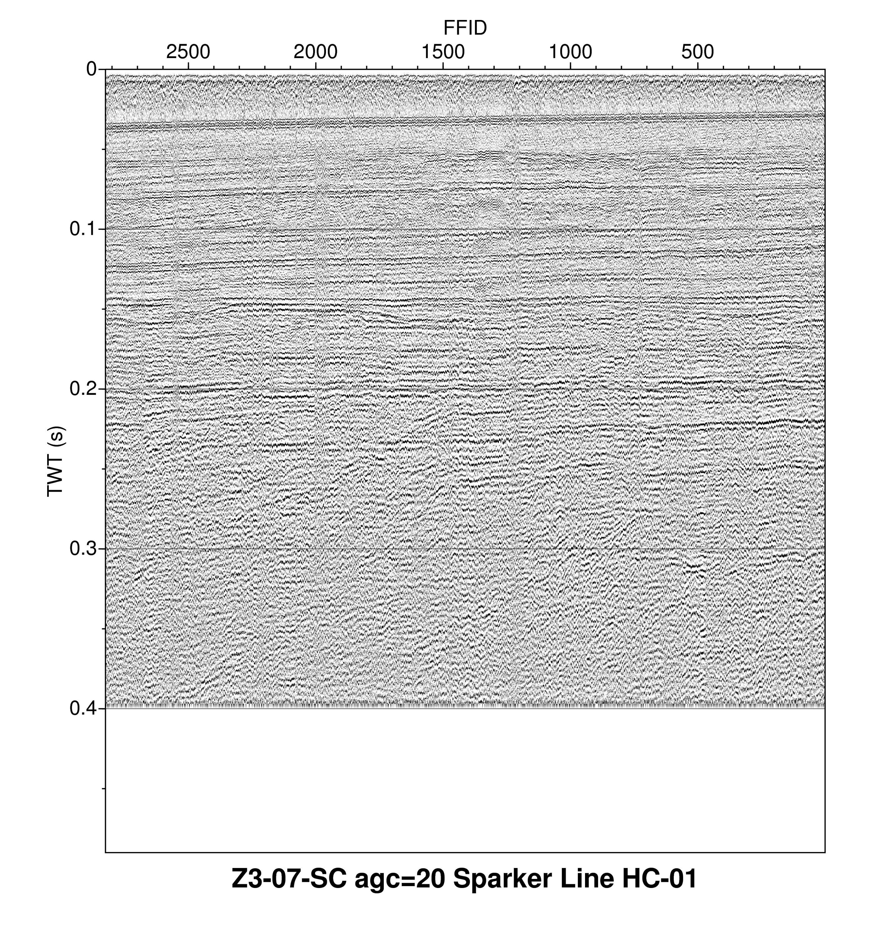
- Browse_Graphic:
-
- Browse_Graphic_File_Name: <https://pubs.usgs.gov/of/2008/1246/data/jpg/HC-01.jpg>
- Browse_Graphic_File_Description:
- Example of single-channel chirp seismic data accessible via this report.
- Browse_Graphic_File_Type: JPEG
- Browse_Graphic:
-
- Browse_Graphic_File_Name: <https://pubs.usgs.gov/of/2008/1246/data/tif/HC-01.tif>
- Browse_Graphic_File_Description:
- Example of single-channel chirp seismic data accessible via this report.
- Browse_Graphic_File_Type: TIFF
- Native_Data_Set_Environment: SEG-Y
- Cross_Reference:
-
- Citation_Information:
-
- Originator: U.S. Geological Survey (USGS), Coastal and Marine Geology (CMG)
- Publication_Date: 2008
- Title: USGS CMG Z-3-07-SC Metadata
- Other_Citation_Details: Updated daily
- Online_Linkage:
-
<http://walrus.wr.usgs.gov/infobank/z/z307sc/html/z-3-07-sc.meta.html>
- Cross_Reference:
-
- Citation_Information:
-
- Originator: U.S. Geological Survey (USGS), Coastal and Marine Geology (CMG)
- Publication_Date: 2008
- Title: USGS CMG Z-7-08-SC Metadata
- Other_Citation_Details: Updated daily
- Online_Linkage:
-
<http://walrus.wr.usgs.gov/infobank/s/s708sc/html/s-7-08-sc.meta.html>
- Data_Quality_Information:
-
- Attribute_Accuracy:
-
- Attribute_Accuracy_Report: Data have not been independently verified.
- Logical_Consistency_Report: Undetermined
- Completeness_Report:
-
Reference the full report for a description of data coverage.
All seismic-reflection data collected on the referenced cruises
have been included in this report.
Some seismic profiles have gaps in them due
to system crashes, mammal shutdowns or hardware maintenance.
- Positional_Accuracy:
-
- Horizontal_Positional_Accuracy:
-
- Horizontal_Positional_Accuracy_Report:
-
Shot point numbers in the data files correspond
to those in the navigation files.
The horizontal positional accuracy of the seismic data thus
linked to ship's position is estimated to be within 30 meters.
- Vertical_Positional_Accuracy:
-
- Vertical_Positional_Accuracy_Report:
-
Depths shown in the seismic data files are
in milliseconds (round trip travel time) and
are referenced to sea level.
- Lineage:
-
- Process_Step:
-
- Process_Description:
- Refer to report sections "Data Acquisition and Processing" for details of geophysical data acquisition and processing sequence used for data in this report. Ray W. Sliter
- Process_Date: 2008
- Process_Step:
-
- Process_Description:
- Created bathymetry overlay using GMT <http://gmt.soest.hawaii.edu/> Peter J. Triezenberg
- Process_Date: 2008
- Process_Step:
-
- Process_Description:
- Created interactive trackline map using Google Maps API <http://code.google.com/apis/maps/> Peter J. Triezenberg
- Process_Date: 2008
- Process_Step:
-
- Process_Description:
- Created downloadable Google Earth "kmz" file <http://code.google.com/apis/kml/> Peter J. Triezenberg
- Process_Date: 2008
- Process_Step:
-
- Process_Description:
- Created seismic profile images using Seismic Unix <http://www.cwp.mines.edu/cwpcodes/> to provide format options for downloading data. Ray W. Sliter
- Process_Date: 2008
- Process_Step:
-
- Process_Description:
- Converted profiles to TIFF and JPEG files using ImageMagick <http://www.imagemagick.org/> Peter J. Triezenberg
- Process_Date: 2008
- Process_Contact:
-
- Contact_Information:
-
- Contact_Organization_Primary:
-
- Contact_Organization: U.S. Geological Survey (USGS), Coastal and Marine Geology (CMG)
- Contact_Person: Ray W. Sliter
- Contact_Position: Geophysicist
- Contact_Address:
-
- Address_Type: mailing and physical address
- Address: USGS, MailStop 999, 345 Middlefield Road
- City: Menlo Park
- State_or_Province: CA
- Postal_Code: 94025-3561
- Country: USA
- Contact_Voice_Telephone: (650) 329-5194
- Contact_Facsimile_Telephone: (650) 329-5190
- Contact_Electronic_Mail_Address: rsliter@usgs.gov
- Process_Step:
-
- Process_Description:
- Used GEODAS (GEOphysical DAta System) to create a custom bathymetric and topographic grid for the southern California region covered by the cruise maps. The website is: <http://www.ngdc.noaa.gov/mgg/geodas/geodas.html>. The parameters used are as follows: Grid Database: US Coastal Relief Model Grids Grid Area in degrees and minutes: 34:30 N to 33:48 N, 119:00 W to 120:24 W Grid Cell Size: 3 seconds Grid Format: XYZ (lon, lat, depth), no header, space-delimited, omit empty grid cells. Cell Parameters: 4-byte floating point, tenths of meters Land/Sea Coverage: Sea cells only. Peter J. Triezenberg
- Process_Date: 2008
- Process_Contact:
-
- Contact_Information:
-
- Contact_Organization_Primary:
-
- Contact_Organization: U.S. Geological Survey (USGS), Coastal and Marine Geology (CMG)
- Contact_Person: Peter J. Triezenberg
- Contact_Position: Geologist
- Contact_Address:
-
- Address_Type: mailing and physical address
- Address: USGS, MailStop 999, 345 Middlefield Road
- City: Menlo Park
- State_or_Province: CA
- Postal_Code: 94025-3561
- Country: USA
- Contact_Voice_Telephone: (650) 329-5207
- Contact_Facsimile_Telephone: (650) 329-5190
- Contact_Electronic_Mail_Address: ptriezenberg@usgs.gov
- Spatial_Data_Organization_Information:
-
- Indirect_Spatial_Reference:
-
Horizontal X and Y locations for the seimic profiles location
are provided in ASCII position files and are also stored
in the SEG-Y data trace headers in the standard header locations.
- Spatial_Reference_Information:
-
- Horizontal_Coordinate_System_Definition:
-
- Planar:
-
- Grid_Coordinate_System:
-
- Grid_Coordinate_System_Name: Universal Transverse Mercator
- Universal_Transverse_Mercator:
-
- UTM_Zone_Number: 11
- Transverse_Mercator:
-
- Scale_Factor_at_Central_Meridian: 0.9996
- Longitude_of_Central_Meridian: -119.0
- Latitude_of_Projection_Origin: 0.0
- False_Easting: 500000
- False_Northing: 0
- Planar_Coordinate_Information:
-
- Planar_Coordinate_Encoding_Method: coordinate pair
- Coordinate_Representation:
-
- Abscissa_Resolution: 3
- Ordinate_Resolution: 3
- Planar_Distance_Units: seconds
- Geodetic_Model:
-
- Horizontal_Datum_Name: World Geodetic System 1984
- Ellipsoid_Name: WGS 84
- Semi-major_Axis: 6378137
- Denominator_of_Flattening_Ratio: 298.257
- Distribution_Information:
-
- Distributor:
-
- Contact_Information:
-
- Contact_Organization_Primary:
-
- Contact_Organization: U.S. Geological Survey (USGS), Coastal and Marine Geology (CMG)
- Contact_Person: Ray W. Sliter
- Contact_Position: Geophysicist
- Contact_Address:
-
- Address_Type: mailing and physical address
- Address: USGS, MailStop 999, 345 Middlefield Road
- City: Menlo Park
- State_or_Province: CA
- Postal_Code: 94025-3561
- Country: USA
- Contact_Voice_Telephone: (650) 329-5194
- Contact_Facsimile_Telephone: (650) 329-5190
- Contact_Electronic_Mail_Address: rsliter@usgs.gov
- Contact_Instructions:
-
Data may be available off-line only by special
arrangement with the distributor above. Please use the on-line
download option unless precluded by download times or access
difficulties.
- Resource_Description:
-
U.S. Geological Suvey Open-File Report 2008-1246
- Distribution_Liability:
-
Please recognize the U.S. Geological Survey (USGS) as
the source of this information.
Physical materials are under controlled on-site access.
Some USGS information accessed through this means may be preliminary in nature and presented without the approval of the Director of the USGS. This information is provided with the understanding that it is not guaranteed to be correct or complete and conclusions drawn from such information are the responsibility of the user.
This information is not intended for navigational purposes.
Any use of trade, firm, or product names is for descriptive purposes only and does not imply endorsement by the U.S. Government.
- Standard_Order_Process:
-
- Digital_Form:
-
- Digital_Transfer_Information:
-
- Format_Name: SEG-Y, JPEG, TIFF, ASCII
- Transfer_Size: 2.5 gigabytes
- Digital_Transfer_Option:
-
- Online_Option:
-
- Computer_Contact_Information:
-
- Network_Address:
-
- Network_Resource_Name: <https://pubs.usgs.gov/of/2008/1246/>
- Offline_Option:
-
- Recording_Format: ISO 9660
- Offline_Media: none
- Fees: None
- Technical_Prerequisites:
-
Use of SEG-Y data requires specialized software,
such as ProMax and Seisworks by Landmark Geophysical;
FOCUS and SeisX by Paradigm Geophysical;
SPW by Parallel Geoscience;
or VISTA by Seismic Image Software.
- Metadata_Reference_Information:
-
- Metadata_Date: 20080724
- Metadata_Contact:
-
- Contact_Information:
-
- Contact_Organization_Primary:
-
- Contact_Organization: U.S. Geological Survey (USGS), Coastal and Marine Geology (CMG)
- Contact_Person: Ray W. Sliter
- Contact_Position: Geophysicist
- Contact_Address:
-
- Address_Type: mailing and physical address
- Address: USGS, MailStop 999, 345 Middlefield Road
- City: Menlo Park
- State_or_Province: CA
- Postal_Code: 94025-3561
- Country: USA
- Contact_Voice_Telephone: (650) 329-5194
- Contact_Facsimile_Telephone: (650) 329-5190
- Contact_Electronic_Mail_Address: rsliter@usgs.gov
- Metadata_Standard_Name:
-
FGDC Content Standards for Digital Geospatial Metadata
- Metadata_Standard_Version: FGDC-STD-001-1998
- Metadata_Time_Convention: universal time
- Metadata_Access_Constraints: none
- Metadata_Use_Constraints: none
For more information contact: Ray Sliter
