USGS Open-File Report 2008-1258
By Matthew D. Merrill and Susan J. Tewalt
2008
The African continent contains approximately 5 percent of the world's proven recoverable reserves of coal (World Energy Council, 2007). Energy consumption in Africa is projected to grow at an annual rate of 2.3 percent from 2004 through 2030, while average consumption in first-world nations is expected to rise at 1.4 percent annually (Energy Information Administration, 2007). Coal reserves will undoubtedly continue to be part of Africa's energy portfolio as it grows in the future. A review of academic and industrial literature indicates that 27 nations in Africa contain coal-bearing rock. South Africa accounts for 96 percent of Africa's total proven recoverable coal reserves, ranking it sixth in the world. This report is a digital compilation of information on Africa's coal-bearing geology found in the literature and is intended to be used in small scale spatial investigations in a Geographic Information System (GIS) and as a visual aid for the discussion of Africa's coal resources.
Many maps of African coal resources often include points for mine locations or regional scale polygons with generalized borders depicting basin edges. Point locations are detailed but provide no information regarding extent, and generalized polygons do not have sufficient detail. In this dataset, the polygons are representative of the actual coal-bearing lithology both in location and regional extent. Existing U.S. Geological Survey (USGS) digital geology datasets provide the majority of the base geologic polygons. Polygons for the coal-bearing localities were clipped from the base geology that represented the age and extent of the coal deposit as indicated in the literature. Where the 1:5,000,000-scale geology base layer's ages conflicted with those in the publications, polygons were generated directly from the regional African coal maps (1:500,000 scale, approximately) in the published material. In these cases, coal-bearing polygons were clipped to the literature's indicated coal extent, without regard to the underlying geology base or topographic constraints.
Indication of the presence of African coal is based on multiple sources. However, the quality of the sources varies and there is often disagreement in the literature. This dataset includes the rank, age, and location of coal in Africa as well as the detailed source information responsible for each coal-bearing polygon. The dataset is not appropriate for use in resource assessments of any kind. Attributes necessary for tasks, such as number of coal seams, thickness of seams, and depth to coal are rarely provided in the literature and accordingly not represented in this data set. Small-scale investigations, representations and display uses are most appropriate for this product. This product is the first to show coal distribution as bounded by actual geologic contacts for the entire African continent. In addition to the spatial component of this dataset, complete references to source material are provided for each polygon, making this product a useful first step resource in African coal research. Greater detail regarding the creation of this dataset as well as the sources used is provided in the metadata file for the Africa_coal.shp file.
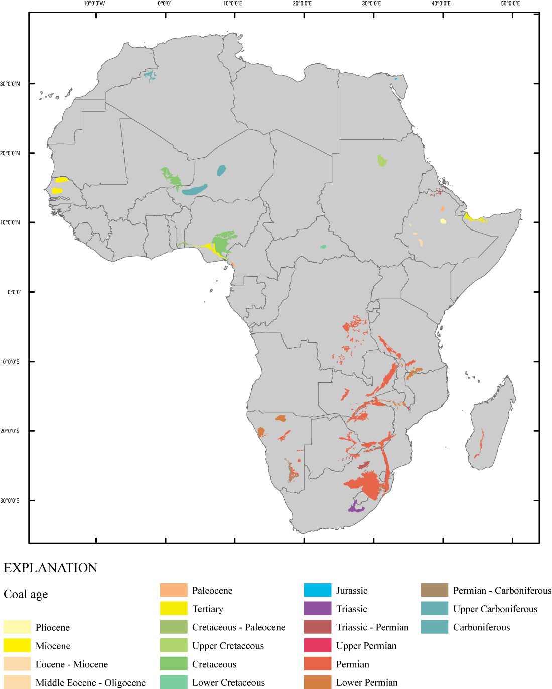
Figure 1. Coal-bearing areas map of the African continent. Colors represent coal age and are based on those adopted by the International Commission on Stratigraphy (International Commission on Stratigraphy, 2008). [Click on image to open larger version in new window.]
The data were compiled in ArcGIS version 9.2 (Environmental Systems Research Institute, Inc, ESRI). The downloadable files have been compressed with WinZip and may be extracted with WinZip on Microsoft Windows operating systems. The ".zip" downloadable file includes data, metadata, and projection parameters. Metadata are provided in text format and as an associated file with the spatial data. Polygon features are shapefiles in geographic coordinates (decimal degrees) with horizontal datum WGS84.
To view the Africa coal dataset, download the Africa_coal.zip file (compressed 2 MB, uncompressed 4.7 MB) and unzip with WinZip or Microsoft Windows. The file Africa_coal.shp contains all polygonal features for coal-bearing areas in Africa. Metadata for the Africa_coal.shp are viewable using ArcCatalog and as a separate text file (Africa_coal.txt); all details regarding this data is explained in the metadata. The file, Africa_coal.mxd can be viewed with the licensed product ArcGIS version 9.2 (ESRI, 2007). Africa_coal.pmf can be viewed with ArcReader (ESRI, 2007), which may be downloaded without charge from http://www.esri.com/software/arcgis/arcreader. The Africa_Coal.kmz dataset can be viewed in Google Earth, another spatial software available for free download.
Data are not intended for use in resource assessments at any scale, but are best used for graphical display at scales smaller than 1:5,000,000.
Neither the U.S. Government, the Department of the Interior, nor the U.S. Geological Survey, nor any of their employees, contractors, or subcontractors, make any warranty, express or implied, nor assume any legal liability or responsibility for the accuracy, completeness, or usefulness of any information, apparatus, product, or process disclosed, nor represent that its use would not infringe on privately owned rights. Although these data have been processed successfully on a computer system at the U.S. Geological Survey, no warranty expressed or implied is made regarding the display or utility of the data on any other system, or for general or scientific purposes, nor shall the act of distribution constitute any such warranty. The U.S. Geological Survey shall not be held liable for improper or incorrect use of the data described and/or contained herein.
This GIS compilation is likely to be superseded in the future if improved information becomes available or if additional effort is invested in refining the method of depicting coal-bearing areas.
Numerous publications were consulted, but a limited number were selected to serve as the best available source of information for these GIS data. Metadata files provide a full listing of published sources utilized in the creation of these files. Christopher Garrity and Joseph East of the USGS are thanked for their insightful reviews of this GIS.
Energy Information Administration, 2007, International Energy Outlook 2007: Energy Information Administration, accessed online September 10, 2007, at http://www.eia.doe.gov/oiaf/ieo/world.html.
International Commission on Stratigraphy, 2008, International Stratigraphic Chart: International Commission on Stratigraphy, accessed online April, 8, 2008, at http://www.stratigraphy.org.
World Energy Council, 2007, Survey of Energy Resources 2007: World Energy Council, accessed online January 8, 2008, at http://www.worldenergy.org/documents/coal_1_1.pdf.
Merrill, M.D., and Tewalt, S.J., 2008, GIS representation of coal-bearing areas in Africa: U.S. Geological Survey Open-File Report 2008-1258, available online at https://pubs.usgs.gov/of/2008/1258/.

![]() U.S. Department of the Interior | U.S. Geological Survey
U.S. Department of the Interior | U.S. Geological Survey
URL: pubsdata.usgs.gov/pubs/of/2008/1258/index.html
Page Contact Information: Matthew D. Merrill
Page Last Modified: September 5, 2008