USGS-NPS-NASA EAARL Topography

LIDAR Illustration

Home-current page

Purpose Link

pdf Maps Link

Raw Data Link

ArcMap Document Link

Metadata Link

Collaborators Lilnk

Open File Report 2008-1326


EAARL Topography-Colonial National Historical Park

John C. Brock1, C. Wayne Wright2, Amar Nayegandhi 3, Sara Stevens4, and Laurinda J. Travers5

1USGS, FISC St. Petersburg, FL, 2NASA,Wallops Flight Facility, Wallops Island, VA, 3Jacob Technology, contacted to USGS, St. Petersburg, FL, 4NPS, Northeastern Coastal and Barrier Network, Inventory and Monitoring Program, Kingston, RI, 5Eckerd College, contracted to USGS, St. Petersburg, FL


This DVD contains 38 Lidar-derived bare earth (BE) topography maps, 39 Lidar-derived first surface (FS) topography maps and GIS files for Colonial National Historical Park, Virginia.

Click on a tile number in either of the graphics below to view the corresponding map as a pdf file.


Map of Gulf Island National Seashore map tiles Tile 32 Tile 39 Tile 1 Tile 2 Tile 4 Tile 3 Tile 7 Tile 5 Tile 6 Tile 10 Tile 11 Tile 12 Tile 13 Tile 17 Tile 18 Tile 16 Tile 14 Tile 15 Tile 19 Tile 8 Tile 9 Tile 20 Tile 23 Tile 24 Tile 22 Tile 21 Tile 25 Tile 26 Tile 27 Tile 29 Tile 28 Tile 30 Tile 31 Tile 33 Tile 34 Tile 35 Tile 38 Tile 37 Tile 36 Tile 36 Tile 37 Tile 38 Tile 35 Tile 34 Tile 33 Tile 32 Tile 31 Tile 30 Tile 28 Tile 29 Tile 27 Tile 26 Tile 25 Tile 21 Tile 22 Tile 24 Tile 23 Tile 20 Tile 9 Tile 8 Tile 19 Tile 15 Tile 14 Tile 16 Tile 18 Tile 17 Tile 13 Tile 12 Tile 11 Tile 10 Tile 6 Tile 5 Tile 7 Tile 3 Tile 4 Tile 2 Tile 1

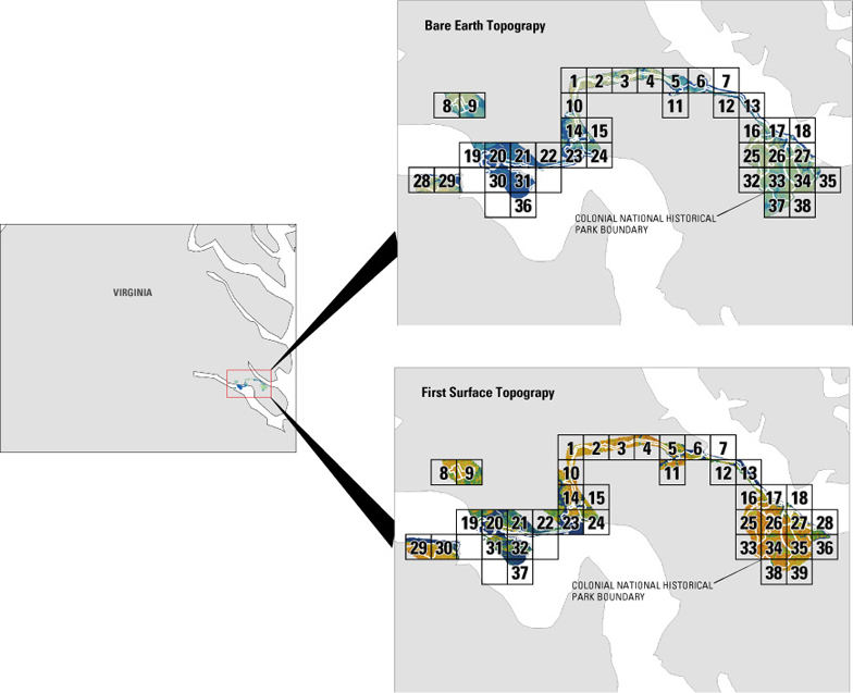
To view a tile as a pdf file, download a free copy of Adobe Reader:    Get Adobe Reader Link

Accessibility FOIA Privacy Policies and Notices

Take Pride in America home page USA Gov LinkU.S. Department of the Interior | U.S. Geological Survey
URL: [DVD Drive]:\start.html
Page Contact Information: Feedback
Page Last Modified: October 14, 2008 (LJT)