N80_1_SHOTNAV.TXT: One-Minute Shotpoint Navigation for Seismic-Reflection Data from Western Rhode Island Sound Formatted for Use With Landmark

Metadata also available as Outline | Text

Frequently-anticipated questions:


What does this data set describe?

Title:
N80_1_SHOTNAV.TXT: One-Minute Shotpoint Navigation for Seismic-Reflection Data from Western Rhode Island Sound Formatted for Use With Landmark
Abstract:
During 1980, a seismic-reflection survey utilizing Uniboom seismics was conducted by the U.S. Geological Survey (USGS) in western Rhode Island Sound aboard the Research Vessel Neecho. This cruise consisted of 2 legs totalling 8 survey days. Data from this survey were recorded in analog form and archived at the USGS. As a result of recent interest in the geology of Rhode Island Sound and in an effort to make the data more readily accessible while preserving the original paper records, the seismic data from this cruise were scanned and converted to TIFF images and SEG-Y data files. Navigation data were converted from LORAN-C time delays to latitudes and longitudes, which are available in ESRI shapefile format and as eastings and northings in space-delimited text format.
  1. How should this data set be cited?

    U.S. Geological Survey, 2009, N80_1_SHOTNAV.TXT: One-Minute Shotpoint Navigation for Seismic-Reflection Data from Western Rhode Island Sound Formatted for Use With Landmark: Open-File Report 2009-1002, U.S. Geological Survey, Coastal and Marine Geology Program, Woods Hole Science Center, Woods Hole, MA.

    Online Links:

    This is part of the following larger work.

    McMullen, K.Y., Poppe, L.J., and Soderberg, N.K., 2009, Digital Seismic-Reflection Data from Western Rhode Island Sound, 1980: Open-File Report 2009-1002, U.S. Geological Survey, Coastal and Marine Geology Program, Woods Hole Science Center, Woods Hole, MA.

    Online Links:

  2. What geographic area does the data set cover?

    West_Bounding_Coordinate: -71.569208
    East_Bounding_Coordinate: -71.130113
    North_Bounding_Coordinate: 41.485329
    South_Bounding_Coordinate: 41.191382

  3. What does it look like?

    <https://pubs.usgs.gov/of/2009/1002/data/nav/n80_1_shotnav/n80_1_shotnav.gif> (GIF)
    Browse image of 1-minute shotpoint navigation from cruise NECH80-1.

  4. Does the data set describe conditions during a particular time period?

    Beginning_Date: 09-Jul-1980, 19800929
    Ending_Date: 17-Jul-1980, 19801002
    Currentness_Reference: ground condition

  5. What is the general form of this data set?

    Geospatial_Data_Presentation_Form: vector digital data

  6. How does the data set represent geographic features?

    1. How are geographic features stored in the data set?

      This is a Point data set. It contains the following vector data types (SDTS terminology):

      • Point

    2. What coordinate system is used to represent geographic features?

      Grid_Coordinate_System_Name: Universal Transverse Mercator
      Universal_Transverse_Mercator:
      UTM_Zone_Number: 19
      Transverse_Mercator:
      Scale_Factor_at_Central_Meridian: 0.999600
      Longitude_of_Central_Meridian: -69.000000
      Latitude_of_Projection_Origin: 0.000000
      False_Easting: 500000.000000
      False_Northing: 0.000000

      Planar coordinates are encoded using coordinate pair
      Abscissae (x-coordinates) are specified to the nearest 1
      Ordinates (y-coordinates) are specified to the nearest 1
      Planar coordinates are specified in meters

      The horizontal datum used is D_WGS_1984.
      The ellipsoid used is WGS_1984.
      The semi-major axis of the ellipsoid used is 6378137.000000.
      The flattening of the ellipsoid used is 1/298.257224.

  7. How does the data set describe geographic features?

    Entity_and_Attribute_Overview:
    Four values per record: Unique Line ID, Shot Number, Easting, and Northing. Eastings and northings are in UTM 19, WGS84.


Who produced the data set?

  1. Who are the originators of the data set? (may include formal authors, digital compilers, and editors)

  2. Who also contributed to the data set?

  3. To whom should users address questions about the data?

    Katherine McMullen
    U.S. Geological Survey
    Sediment Lab Technician
    384 Woods Hole Road
    Woods Hole, MA 02543
    USA

    (508) 548-8700 x2277 (voice)
    (508) 457-2310 (FAX)
    kmcmullen@usgs.gov


Why was the data set created?

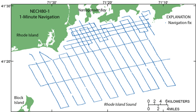
This GIS layer contains the 1-minute shotpoint navigation for seismic data collected aboard the R/V Neecho during a 1980 geophysical cruise in western Rhode Island Sound. It is part of a digital version of a regional map showing the distribution of sub-bottom seismic profiles collected in Rhode Island Sound. The seismic data collected along these ship tracks provide useful information about the framework geology in this region.


How was the data set created?

  1. From what previous works were the data drawn?

    Cruise Log, R/V Neecho, Western Rhode Island Sound (source 1 of 1)
    O'Hara, C., Wood-Needell, S., Jennings, F., and Loud, P., 1980, Cruise Log, R/V Neecho, Western Rhode Island Sound, Cruise NEE-80-1.

    Online Links:

    Type_of_Source_Media: log book
    Source_Contribution:
    LORAN-C navigation data were recorded during field work in western Rhode Island Sound. This data set contains the latitude and longitude coordinates converted from the LORAN-C time delays.

  2. How were the data generated, processed, and modified?

    Date: 2009 (process 1 of 2)
    An UNICODE text file containing unique line identification, easting, northing, and shot number was exported from ArcMap 9.2 using XToolsPro Version 4.1.0 Export Table to Text. The text file was opened in WordPad and saved as ANSI text.

    Person who carried out this activity:

    Jane Denny
    U.S. Geological Survey
    Geologist
    384 Woods Hole Road
    Woods Hole, MA 02543
    USA

    (508) 548-8700 x2311 (voice)
    (508) 457-2310 (FAX)
    jdenny@usgs.gov

    Data sources used in this process:
    • n80_1_1minnav_sort.shp

    Data sources produced in this process:

    • n80_1_1minnav.txt

    Date: 2009 (process 2 of 2)
    The text file was transferred to a LINUX computer and converted from DOS to Unix using Dos2Unix command. An AWK script was used to reformat the text file as right justified fields with space delimiters in the order Unique Line ID, shot number, easting, and northing, in order to generate a format ready to import into the seismic interpretation package, LandMark Graphics, Seisworks. The easting and northing values are rounded to the nearest meter.

    Person who carried out this activity:

    Jane Denny
    U.S. Geological Survey
    Geologist
    384 Woods Hole Road
    Woods Hole, MA 02543
    USA

    (508) 548-8700 x2311 (voice)
    (508) 457-2310 (FAX)
    jdenny@usgs.gov

    Data sources used in this process:
    • n80_1_1minnav.txt

    Data sources produced in this process:

    • n80_1_shotnav.txt

  3. What similar or related data should the user be aware of?

    Needell, S.W., O'Hara, C.J., and Knebel, H.J., 1983, Maps showing geology and shallow structure of western Rhode Island Sound, Rhode Island: U.S. Geological Survey Miscellaneous Field Studies Map MF-1537, U.S. Geological Survey, Coastal and Marine Geology Program, Woods Hole Science Center, Woods Hole, MA.


How reliable are the data; what problems remain in the data set?

  1. How well have the observations been checked?

    Attribute data were recorded by the science party and entered and checked by the compilers in a consistent manner.

  2. How accurate are the geographic locations?

    All navigation was done by LORAN-C and was manually recorded. The cruise used the Group Repetition Interval 9960 Northeast U.S. chain and recorded time delays from Caribou, Maine (W) and Carolina Beach, N.C. (Y) slave transmitters. Absolute accuracy is 185 to 463 m based on <http://www.navcen.uscg.gov/loran/handbook/h-book.htm> (see Chapter III).

  3. How accurate are the heights or depths?

  4. Where are the gaps in the data? What is missing?

    Complete information is provided for all navigation lines in the data set. Navigation points are spaced at 1-minute intervals and at course changes or line events (start/end of line). Continuous navigation is not available.

  5. How consistent are the relationships among the observations, including topology?

    The layers were edited and processed in a consistent manner.


How can someone get a copy of the data set?

Are there legal restrictions on access or use of the data?

Access_Constraints: None
Use_Constraints:
Public domain data are freely redistributable with proper metadata and source attribution. Please recognize the U.S. Geological Survey as the originator of this dataset.

  1. Who distributes the data set? (Distributor 1 of 1)

    Lawrence Poppe
    U.S. Geological Survey
    Geologist
    384 Woods Hole Road
    Woods Hole, MA 02543
    USA

    (508) 548-8700 x2314 (voice)
    (508) 457-2310 (FAX)
    lpoppe@usgs.gov

  2. What's the catalog number I need to order this data set?

    Downloadable Data: n80_1_shotnav.txt

  3. What legal disclaimers am I supposed to read?

    Neither the U.S. Government, the Department of the Interior, nor the USGS, nor any of their employees, contractors, or subcontractors, make any warranty, express or implied, nor assume any legal liability or responsibility for the accuracy, completeness, or usefulness of any information, apparatus, product, or process disclosed, nor represent that its use would not infringe on privately owned rights. The act of distribution shall not constitute any such warranty, and no responsibility is assumed by the USGS in the use of these data or related materials. Any use of trade, product, or firm names is for descriptive purposes only and does not imply endorsement by the U.S. Government.

  4. How can I download or order the data?

  5. What hardware or software do I need in order to use the data set?

    The user must have a program capable of uncompressing the WinZip 9.0 file, and of reading and processing the navigation text file (formatted to import into LandMark Graphics, Seisworks).


Who wrote the metadata?

Dates:
Last modified: 13-May-2009
Metadata author:
U.S. Geological Survey
c/o Katherine McMullen
Sediment Lab Technician
384 Woods Hole Road
Woods Hole, MA 02543
USA

(508) 548-8700 x2277 (voice)
(508) 457-2310 (FAX)
kmcmullen@usgs.gov

Metadata standard:
FGDC Content Standards for Digital Geospatial Metadata (FGDC-STD-001-1998)
Metadata extensions used:


Generated by mp version 2.9.6 on Wed May 13 14:08:13 2009