A80_6SEGY.TXT: Seismic-Reflection Profiles in SEG-Y Format From Southern Rhode Island Sound

Metadata also available as Outline | Text

Frequently-anticipated questions:


What does this data set describe?

Title:
A80_6SEGY.TXT: Seismic-Reflection Profiles in SEG-Y Format From Southern Rhode Island Sound
Abstract:
During 1980, the U.S. Geological Survey (USGS) conducted a seismic-reflection survey utilizing Uniboom seismics in southern Rhode Island Sound aboard the Research Vessel Asterias. This cruise totalled 3 survey days. Data from this survey were recorded in analog form and archived at the USGS. Due to recent interest in the geology of Rhode Island Sound and in an effort to make the data more readily accessible while preserving the original paper records, the seismic data from this cruise were scanned and converted to TIFF images and SEG-Y data files. Navigation data were converted from LORAN-C time delays to latitudes and longitudes, which are available in ESRI shapefile format and as eastings and northings in space-delimited text format.
  1. How should this data set be cited?

    U.S. Geological Survey, 2009, A80_6SEGY.TXT: Seismic-Reflection Profiles in SEG-Y Format From Southern Rhode Island Sound: Open-File Report 2009-1003, U.S. Geological Survey, Coastal and Marine Geology Program, Woods Hole Science Center, Woods Hole, MA.

    Online Links:

    This is part of the following larger work.

    McMullen, K.Y., Poppe, L.J., and Soderberg, N.K., 2009, Digital Seismic-Reflection Data from Eastern Rhode Island Sound and Vicinity, 1975-1980: Open-File Report 2009-1003, U.S. Geological Survey, Coastal and Marine Geology Program, Woods Hole Science Center, Woods Hole, MA.

    Online Links:

    Other_Citation_Details: 2 DVD-ROMs

  2. What geographic area does the data set cover?

    West_Bounding_Coordinate: -71.215370
    East_Bounding_Coordinate: -70.637272
    North_Bounding_Coordinate: 41.502251
    South_Bounding_Coordinate: 41.233566

  3. What does it look like?

    <https://pubs.usgs.gov/of/2009/1003/data/seismics/sris/segy/a80_6lines.gif> (GIF)
    Browse image of seismic-line locations from cruise AST-80-6B.

  4. Does the data set describe conditions during a particular time period?

    Beginning_Date: 10-Jun-1980
    Ending_Date: 12-Jun-1980
    Currentness_Reference: ground condition

  5. What is the general form of this data set?

    Geospatial_Data_Presentation_Form: profile

  6. How does the data set represent geographic features?

    1. How are geographic features stored in the data set?

    2. What coordinate system is used to represent geographic features?

  7. How does the data set describe geographic features?


Who produced the data set?

  1. Who are the originators of the data set? (may include formal authors, digital compilers, and editors)

  2. Who also contributed to the data set?

  3. To whom should users address questions about the data?

    Katherine McMullen
    U.S. Geological Survey
    Sediment Lab Technician
    384 Woods Hole Road
    Woods Hole, MA 02543
    USA

    (508) 548-8700 x2277 (voice)
    (508) 457-2310 (FAX)
    kmcmullen@usgs.gov


Why was the data set created?

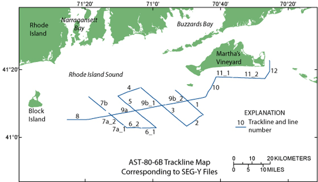
This data set contains the seismic-reflection data in SEG-Y format collected aboard the R/V Asterias during a 1980 geophysical cruise in southern Rhode Island Sound. It is a digital version of the seismic data collected on the cruise and can be used in seismic interpretation software. The seismic data can be used to provide useful information about the framework geology in this region. This metadata describes the SEG-Y data as a whole.


How was the data set created?

  1. From what previous works were the data drawn?

    Original seismic-reflection profiles (source 1 of 1)

  2. How were the data generated, processed, and modified?

    Date: 1980 (process 1 of 5)
    Original seismic records of cruise AST-80-6B were obtained using a towed EG&G Uniboom system, towed 15 m astern of the vessel, with a half-second fire rate. The signal was amplified and filtered to a 400- to 4000-Hz bandpass. The seismic data have 1- to 2-m resolution. Seismic data were printed on EPC recorders at a quarter-second sweep rate. The ship speed averaged 5 knots. Shipboard systems include: EG&G Uniboom Catamaran with mounted transducer, EG&G Trigger-Capacitor Bank, EPC Seismic Recorder (4100 series), Teledyne Exploration Seismic Amplifier (Model 300), Del Norte Hydrophone Streamer (30 element), Krohn-Hite Band Pass Filter, Northstar 6000 Loran C Receiver and Repeater.

    Date: 2008 (process 2 of 5)
    Original seismic records were scanned at 300 dpi, 8-bit grayscale on an Ideal Contex Crystal TX 40 scanner using Ideal ScanOS version 2.5.4 software and saved as TIFFs, after being roughly rotated and cropped. Some seismic lines were too long to scan at once and were cut into sections, other lines were collected in sections. These sections are noted in the file names with lower-case letters after the line number. For instance, a80_607a_1.tif signifies the cruise as R/V Asterias in 1980 (AST-80-6B), line 7, section a, SEG-Y segment _1, and TIFF format.

    Person who carried out this activity:

    Katherine McMullen
    U.S. Geological Survey
    Sediment Lab Technician
    384 Woods Hole Road
    Woods Hole, MA 02543
    USA

    (508) 548-8700 x2277 (voice)
    (508) 457-2310 (FAX)
    kmcmullen@usgs.gov

    Date: 2008 (process 3 of 5)
    TIFFs were then opened in Adobe Photoshop CS2 and saved as 200 dpi grayscale TIFFs.

    Person who carried out this activity:

    Katherine McMullen
    U.S. Geological Survey
    Sediment Lab Technician
    384 Woods Hole Road
    Woods Hole, MA 02543
    USA

    (508) 548-8700 x2277 (voice)
    (508) 457-2310 (FAX)
    kmcmullen@usgs.gov

    Date: 2008 (process 4 of 5)
    Grayscale TIFFs were further processed in Adobe Photoshop CS2 in order to aid in creating the SEG-Y files. These TIFF images were rotated so they were nearly perfectly horizontal, cropped to start and end shots with known positions, and resampled using bicubic filtering, such that each horizontal pixel of the image corresponds to a trace and each vertical pixel corresponds to a time sample, based on a 0.5 second fire rate and 0.25 sec sweep rate (250 ms) and an assumed 0.08 sample rate. For instance, a 30-minute image is 3600 shots/pixels wide (30*60/0.5) and 3125 pixels high (250 ms/0.08 ms). Seismic-reflection profiles that had noted changes in ship speed or places where recording stopped for belt changes were split into segments, so each file was obtained at roughly the same speed. These segments are labeled with _1 or _2 after the section, thus the file names differ slightly from the line names as used in the logbook. Since TIFF images were clipped in the process of making SEG-Y files, users are encouraged to view the TIFF images available in this report (<https://pubs.usgs.gov/of/2009/1003/html/sris_prof.html>) in order to see field notes related to data acquisition and weather conditions, which were written directly on the paper records.

    Person who carried out this activity:

    Katherine McMullen
    U.S. Geological Survey
    Sediment Lab Technician
    384 Woods Hole Road
    Woods Hole, MA 02543
    USA

    (508) 458-8700 x2277 (voice)
    (508) 457-2310 (FAX)
    kmcmullen@usgs.gov

    Date: 2009 (process 5 of 5)
    Rotated, cropped, and resampled grayscale TIFFs were run through tif2segy, a Unix shell script written by Andrew MacRae (Saint Mary's University, Nova Scotia) and used to convert TIFFs to SEG-Y format. Tif2segy requires two other programs to run successfully: Seismic Unix (<http://www.cwp.mines.edu/cwpcodes>) and Netpbm tools (<http://netpbm.sourceforge.net>). The default sample interval within the Tif2segy script was edited and set to 80 microseconds using the Unix text editor, vi. The ASCII header was also edited to reflect the current processor and processing date. Quality control was performed by viewing the SEG-Y files using SeisVU SEG-Y File Viewer (1.0.0.1).

    Person who carried out this activity:

    Katherine McMullen
    U.S. Geological Survey
    Sediment Lab Technician
    384 Woods Hole Road
    Woods Hole, MA 02543
    USA

    (508) 548-8700 x2277 (voice)
    (508) 457-2310 (FAX)
    kmcmullen@usgs.gov

  3. What similar or related data should the user be aware of?

    O'Hara, C.J., and Oldale, R.N., 1980, Maps showing geology and shallow structure of eastern Rhode Island Sound and Vineyard Sound, Massachusetts: Miscellaneous Field Studies Map MF-1186, U.S. Geological Survey, Coastal and Marine Geology Program, Woods Hole Science Center, Woods Hole, MA.

    McMullen, K.Y., Poppe, L.J., and Soderberg, N.K., 2009, Digital Seismic-Reflection Data from Western Rhode Island Sound, 1980: Open-File Report 2009-1002, U.S. Geological Survey, Coastal and Marine Geology Program, Woods Hole Science Center, Woods Hole, MA.

    Online Links:

    Barry, K.M., Cavers, D.A., and Kneale, C.W., 1975, Report on recommended standards for digital tape formats: Geophysics 40, no. 02, p. 344-352.

    Online Links:


How reliable are the data; what problems remain in the data set?

  1. How well have the observations been checked?

  2. How accurate are the geographic locations?

  3. How accurate are the heights or depths?

  4. Where are the gaps in the data? What is missing?

    All available SEG-Y data along seismic acquisition lines collected during the R/V Asterias cruise AST-80-6B is included in this data set.

  5. How consistent are the relationships among the observations, including topology?

    The data were edited and processed in a consistent manner.


How can someone get a copy of the data set?

Are there legal restrictions on access or use of the data?

Access_Constraints: None
Use_Constraints:
Public domain data are freely redistributable with proper metadata and source attribution. Please recognize the U.S. Geological Survey as the originator of this dataset.

  1. Who distributes the data set? (Distributor 1 of 1)

    Lawrence Poppe
    U.S. Geological Survey
    Geologist
    384 Woods Hole Road
    Woods Hole, MA 02543
    USA

    (508) 548-8700 x2314 (voice)
    (508) 457-2310 (FAX)
    lpoppe@usgs.gov

  2. What's the catalog number I need to order this data set?

    Downloadable Data: WinZipped SEG-Y seismic data files.

  3. What legal disclaimers am I supposed to read?

    Neither the U.S. Government, the Department of the Interior, nor the USGS, nor any of their employees, contractors, or subcontractors, make any warranty, express or implied, nor assume any legal liability or responsibility for the accuracy, completeness, or usefulness of any information, apparatus, product, or process disclosed, nor represent that its use would not infringe on privately owned rights. The act of distribution shall not constitute any such warranty, and no responsibility is assumed by the USGS in the use of these data or related materials. Any use of trade, product, or firm names if for descriptive purposes only and does not imply endorsement by the U.S. Government.

  4. How can I download or order the data?

  5. What hardware or software do I need in order to use the data set?

    The WinZip 9.0 file contains a SEG-Y formatted seismic-reflection profile. The user must be able to uncompress the zip file and have software capable of reading SEG-Y standard files.


Who wrote the metadata?

Dates:
Last modified: 01-Jun-2009
Metadata author:
U.S. Geological Survey
c/o Katherine McMullen
Sediment Lab Technician
384 Woods Hole Road
Woods Hole, MA 02543
USA

(508) 548-8700 x2277 (voice)
(508) 457-2310 (FAX)
kmcmullen@usgs.gov

Metadata standard:
FGDC Content Standards for Digital Geospatial Metadata (FGDC-STD-001-1998)
Metadata extensions used:


Generated by mp version 2.9.6 on Mon Jun 01 13:19:12 2009