Skip Links

USGS - science for a changing world

Open-File Report 2009-1129

Aeromagnetic and Aeroradiometric Data for the Conterminous United States and Alaska from the National Uranium Resource Evaluation (NURE) Program of the U.S. Department of Energy

By Patricia L. Hill¹, Robert P. Kucks¹, and Dhananjay Ravat²

¹U.S. Geological Survey
²University of Kentucky, Lexington, KY

California NURE Aeromagnetic and Aeroradiometric Data

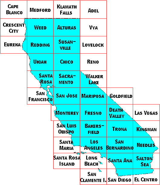
California Quadrangle Index Map

Image Map for selecting quadrangles in California. Equivalent text links provided below.

Note: The Monterey Quadrangle is the old Santa Cruz Quadrangle and the Cape Blanco Quadrangle is the south part of the old Coos Bay Quadrangle.

Quadrangles without NURE magnetic and radiometric data
  • Long Beach
  • Santa Rosa Island
  • San Clamente Island

Links Associated with this Report

USGS National Geophysical Database project
NURE Airborne Data Files and Formats
Go directly to the USGS digital magnetics site.
Go directly to the USGS digitized magnetics site.

This report is preliminary and has not been reviewed for conformity with U.S. Geological Survey editorial standards. Use of brand names is for descriptive purposes and does not constitute endorsement by the U.S. Geological Survey.
Last modified 07/31/2009.
Cape Blanco Quadrangle Medford Quadrangle Klamath Falls Quadrangle Adel Quadrangle Crescent City Quadrangle Weed Quadrangle Alturas Quadrangle Vya Quadrangle Eureka Quadrangle Redding Quadrangle Susanville Quadrangle Lovelock Quadrangle Ukiah Quadrangle Chico Quadrangle Reno Quadrangle Santa Rosa Quadrangle Sacramento Quadrangle Walker Lake Quadrangle San Francisco Quadrangle San Jose Quadrangle Mariposa Quadrangle Goldfield Quadrangle Monterey Quadrangle Fresno Quadrangle Death Valley Quadrangle Las Vegas Quadrangle San Luis Obispo Quadrangle Bakersfield Quadrangle Trona Quadrangle Kingman Quadrangle Santa Maria Quadrangle Los Angeles Quadrangle San Bernardino Quadrangle Needles Quadrangle Santa Rosa Island Quadrangle Long Beach Quadrangle Santa Ana Quadrangle Salton Sea Quadrangle San Clemente Island Quadrangle San Diego Quadrangle El Centro Quadrangle Image Map for selecting quadrangles in California. Equivalent text links provided below.

Accessibility FOIA Privacy Policies and Notices

Take Pride in America logo USA.gov logo U.S. Department of the Interior | U.S. Geological Survey
URL: http://pubsdata.usgs.gov/pubs/of/2009/1129/state/nure_ca.htm
Page Contact Information: GS Pubs Web Contact
Page Last Modified: Wednesday, 07-Dec-2016 22:02:50 EST