Skip Links

USGS - science for a changing world

Open-File Report 2009-1129

Aeromagnetic and Aeroradiometric Data for the Conterminous United States and Alaska from the National Uranium Resource Evaluation (NURE) Program of the U.S. Department of Energy

By Patricia L. Hill¹, Robert P. Kucks¹, and Dhananjay Ravat²

¹U.S. Geological Survey
²University of Kentucky, Lexington, KY

Colorado NURE Aeromagnetic and Aeroradiometric Data

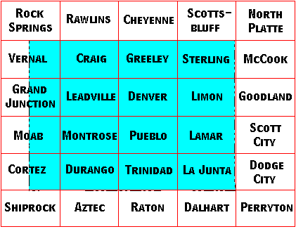
Colorado Quadrangle Index Map

Image Map for selecting quadrangles in Colorado. Equivalent text links provided below.


Colorado Detail Areas (small areas flown at 0.25 mile line spacing)


Links Associated with this Report

USGS National Geophysical Database project
NURE Airborne Data Files and Formats
Go directly to the USGS digital magnetics site.
Go directly to the USGS digitized magnetics site.

This report is preliminary and has not been reviewed for conformity with U.S. Geological Survey editorial standards. Use of brand names is for descriptive purposes and does not constitute endorsement by the U.S. Geological Survey.
Last modified 07/31/2009.
Rock Springs Quadrangle Rawlins Quadrangle Cheyenne Quadrangle Scottsbluff Quadrangle North Platte Quadrangle Vernal Quadrangle Craig Quadrangle Greeley Quadrangle Sterling Quadrangle McCook Quadrangle Grand Junction Quadrangle Leadville Quadrangle Denver Quadrangle Limon Quadrangle Goodland Quadrangle Moab Quadrangle Montrose Quadrangle Pueblo Quadrangle Lamar Quadrangle Scott City Quadrangle Cortez Quadrangle Durango Quadrangle Trinidad Quadrangle La Junta Quadrangle Dodge City Quadrangle Shiprock Quadrangle Aztec Quadrangle Raton Quadrangle Dalhart Quadrangle Perryton Quadrangle Image Map for selecting quadrangles in Colorado.

Accessibility FOIA Privacy Policies and Notices

Take Pride in America logo USA.gov logo U.S. Department of the Interior | U.S. Geological Survey
URL: http://pubsdata.usgs.gov/pubs/of/2009/1129/state/nure_co.htm
Page Contact Information: GS Pubs Web Contact
Page Last Modified: Wednesday, 07-Dec-2016 22:02:50 EST