Open File Report 2009-1250
Prepared in cooperation with the National Park Service (NPS).
1 U.S. Geological Survey, St. Petersburg, FL 33703,
2Jacobs Technology, contracted to U.S. Geological Survey, New Orleans, LA 70128
Contents
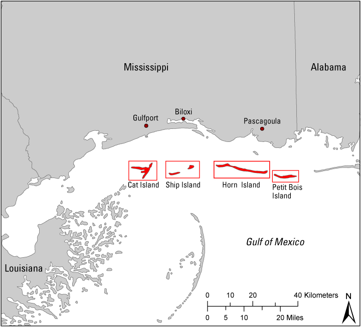
The U.S. Geological Survey (USGS) is studying coastal hazards and coastal change to improve our understanding of coastal ecosystems and to develop better capabilities of predicting future coastal change. One approach to understanding the dynamics of coastal systems is to monitor changes in barrier-island subenvironments through time. This involves examining morphological and topographic change at temporal scales ranging from millennia to years and spatial scales ranging from tens of kilometers to meters. Of particular interest are the processes that produce those changes and the determination of whether or not those processes are likely to persist into the future. In these analyses of hazards and change, both natural and anthropogenic influences are considered. Quantifying past magnitudes and rates of coastal change and knowing the principal factors that govern those changes are critical to predicting what changes are likely to occur under different scenarios, such as short-term impacts of extreme storms or long-term impacts of sea-level rise. Gulf Islands National Seashore was selected for detailed mapping of barrier-island morphology and topography because the islands offer a diversity of depositional subenvironments and the islands' areas and positions have changed substantially in historical time. The geomorphologic and subenvironmental maps emphasize the processes that formed the surficial features and also serve as a basis for documenting which subenvironments are relatively stable, such as the beach ridge complex, and those which are highly dynamic, such as the beach and active overwash zones.
The primary mapping procedures used supervised functions within a Geographic Information System (GIS) that classified depositional subenvironments and features (map units) and delineated boundaries of the features (shapefiles). The GIS classified units on the basis of tonal patterns of a feature in contrast to adjacent features observed on georeferenced aerial photographs. Land elevations from recent lidar surveys served as supplementary data to assist in delineating the map-unit boundaries.
The Geomorphology and Depositional Subenvironments of Gulf Islands National Seashore
Click on the links below to download the PDF map tiles or on the index map to view the map tiles in JPEG format. You will need to have the free Adobe Acrobat® Reader installed on your computer to view and print the high resolution PDF map tiles.
Print Versions
View On Screen Versions

These datasets include shapefiles for each data-layer classification relevant to the individual island.
The barrier-island classification was referenced and mapped using September 2007 high-resolution orthorectified aerial photography from the National Agriculture Imagery Program (NAIP), October 2007 low-altitude color videos of the Mississippi barrier islands acquired from Great Divide Pictures under contract to the National Park Service (NPS), and June 2007 1-meter-pixel-resolution Experimental Advanced Airborne Research Lidar (EAARL) collected by National Aeronautics and Space Administration (NASA) and the USGS. Each geomorphic layer is stored in standard shapefile format viewable in any GIS software.
The following links will open general metadata text files associated with each class shapefile for Gulf Islands National Seashore. View the more detailed Extensible Markup Language (XML) files, accessible in metadata readers such as ESRI ArcCatalog, from their respective folders in the Project Data sections listed above.
  Chaney, P.L., and Stone, G.W., 1996, Soundside erosion of a nourished beach and implications for winter cold front forcing:

    West Ship Island, Mississippi: Shore and Beach, v. 64, p. 27-33.


  Fritz, H.M., Blount, C., Sokoloski, R., Singleton, N.J., Fuggle, A., McAdoo, B.G., Moore, A., Grass, C., and Tate, B., 2007,

    Hurricane Katrina storm surge distribution and field observations on the Mississippi barrier islands: Estuarine, Coastal and

    Shelf Science, v. 74, p. 12-20.


  Morton, R.A., 2007, Historical changes in the Mississippi-Alabama barrier islands and the roles of extreme storms, sea level,

     and human activities: U.S. Geological Survey Open-File Report 2007-1161, 38 p. (Available online at: https://pubs.usgs.gov/of/2007/1161/)


  Morton, R.A., Guy, K., and Whitko, A., 2007, Morphological impacts of Hurricane Camille (1969) on barrier islands of Mississippi

     and western Alabama: U.S. Geological Survey website at: http://coastal.er.usgs.gov/hurricanes/historical-storms/camille/.


  Otvos, E.G., 1979, Barrier-island evolution and history of migration, north central Gulf Coast, in Leatherman, S.P. ed., Barrier islands

     from the Gulf of St. Lawrence to the Gulf of Mexico: New York, Academic Press, p. 291-319.


  Penfound, W.T., and O'Neill, M.E., 1934, The vegetation of Cat Island, Mississippi: Ecology, v. 15, p. 1-16.


  Pessin, L.J., and Burleigh, T.D., 1941, Notes on the forest biology of Horn Island: Ecology, v. 22, p. 70-78.


  Rucker, J.B., and Snowden, J.O., 1988, Recent morphologic changes at Dog Key Pass, Mississippi; The formation and disappearance

     of the Isle of Caprice: Gulf Coast Association of Geologoical Societies Transactions, v. 38, p. 343-349.


  Waller, T.H., and Malbrough, L.P., 1976, Temporal changes in the offshore islands of Mississippi: Mississippi State University

     Water Resources Research Institute, 109 p.