Open-File Report 2010-1005
1Coastal and Marine Geology Program, U.S. Geological Survey, Woods Hole, MA 02543
2Office of Coast Survey, NOAA, Norfolk, VA 23510
3Marine Operations Center–Atlantic, NOAA, Norfolk, VA 23510
4Connecticut Department of Environmental Protection, Hartford, CT 06106
ABSTRACT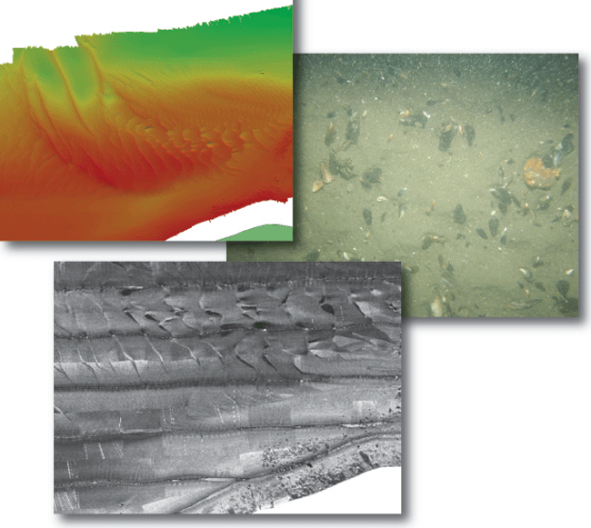
The U.S. Geological Survey (USGS), the Connecticut Department of Environmental Protection, and the National Oceanic and Atmospheric Administration (NOAA) have been working cooperatively to interpret surficial sea-floor geology along the coast of the Northeastern United States. NOAA survey H11445 in eastern Long Island Sound, offshore of Plum Island, New York, covers an area of about 12 square kilometers. Multibeam bathymetry and sidescan-sonar imagery from the survey, as well as sediment and photographic data from 13 stations occupied during a USGS verification cruise are used to delineate sea-floor features and characterize the environment. Bathymetry gradually deepens offshore to over 100 meters in a depression in the northwest part of the study area and reaches 60 meters in Plum Gut, a channel between Plum Island and Orient Point. Sand waves are present on a shoal north of Plum Island and in several smaller areas around the basin. Sand-wave asymmetry indicates that counter-clockwise net sediment transport maintains the shoal. Sand is prevalent where there is low backscatter in the sidescan-sonar imagery. Gravel and boulder areas are submerged lag deposits produced from the Harbor Hill-Orient Point-Fishers Island moraine segment and are found adjacent to the shorelines and just north of Plum Island, where high backscatter is present in the sidescan-sonar imagery. |
Posted July 2010 For additional information contact: Part or all of this report is presented in Portable Document Format (PDF); the latest version of Adobe Reader or similar software is required to view it. Download the latest version of Adobe Reader, free of charge. |
McMullen, K.Y., Poppe, L.J., Danforth, W.W., Blackwood, D.S., Schaer, J.D., Ostapenko, A.J., Glomb, K.A, and Doran, E.F., 2010, Surficial geology of the sea floor in Long Island Sound offshore of Plum Island, New York: U.S. Geological Survey Open-File Report 2010–1005, CD-ROM. (Also available at https://pubs.usgs.gov/of/2010/1005/.)
Abstract
Introduction
Setting
Methods
Bathymetry
Sidescan Sonar
Sediments
Bottom Photography
GIS Data Catalog
Summary
Acknowledgments
References
Contacts

![]() U.S. Department of the Interior |
U.S. Geological Survey
U.S. Department of the Interior |
U.S. Geological Survey
[an error occurred while processing this directive]
URL: https://pubsdata.usgs.gov
Page Contact Information: Contact USGS
Page Last Modified: Wednesday, 07-Dec-2016 22:35:23 EST
