More information about the individual USGS surveys conducted as part of the northern Cape Cod Bay project can be found on the Woods Hole Coastal and Marine Science Center Field Activity webpage:
06012: <http://quashnet.er.usgs.gov/data/2006/06012/> 07001: <http://quashnet.er.usgs.gov/data/2007/07001/> 07002: <http://quashnet.er.usgs.gov/data/2007/07002/> 07003: <http://quashnet.er.usgs.gov/data/2007/07003/> 08002: <http://quashnet.er.usgs.gov/data/2008/08002/>
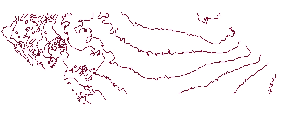
U.S. Geological Survey, 2010, CCB_5MCNTR: Bathymetric depth contours at 5 meter intervals of interferometric sonar data collected offshore of Massachusetts within northern Cape Cod Bay (ESRI Shapefile, Geographic, WGS84).: Open-File Report 2010-1006, U.S. Geological Survey, Coastal and Marine Geology Program, Woods Hole Coastal and Marine Science Center, Woods Hole, Massachusetts.This is part of the following larger work.Online Links:
- <https://pubs.usgs.gov/of/2010/1006/GIS/shapefile/CCB_5mCntr.zip>
- <https://pubs.usgs.gov/of/2010/1006/html/appendix1.html>
Andrews, Brian D. , Ackerman, Seth D. , Baldwin, Wayne E. , and Barnhardt, Walter A. , 2010, Geophysical and Sampling Data from the Inner Continental Shelf: Northern Cape Cod Bay, Massachusetts.: Open-File Report 2010-1006, U.S. Geological Survey, Coastal and Marine Geology Program, Woods Hole Coastal and Marine Science Center, Woods Hole, Massachusetts.Online Links:
This is a Vector data set. It contains the following vector data types (SDTS terminology):
Horizontal positions are specified in geographic coordinates, that is, latitude and longitude. Latitudes are given to the nearest 0.000001. Longitudes are given to the nearest 0.000001. Latitude and longitude values are specified in Decimal degrees.
The horizontal datum used is D_WGS_1984.
The ellipsoid used is WGS_1984.
The semi-major axis of the ellipsoid used is 6378137.000000.
The flattening of the ellipsoid used is 1/298.257224.
Sequential unique whole numbers that are automatically generated.
Coordinates defining the features.
| Range of values | |
|---|---|
| Minimum: | -60 |
| Maximum: | -5 |
| Range of values | |
|---|---|
| Minimum: | 508.9 |
| Maximum: | 44,981.8 |
508-548-8700 x2348 (voice)
508-457-2310 (FAX)
bandrews@usgs.gov
The purpose of this polyline shapefile is to show bathymetric contours at 5 meter intervals derived from bathymetry collected during the four surveys (06012, 07001, 07002, 08002) in the northern Cape Cod Bay survey area.
2) Convert resolution of input raster (BlockSt_ccb_1) from 5-m per pixel to 50-m per pixel using the aggregate tool in ArcToolbox (ver. 9.3) Input raster = BlockSt_ccb_1, Output raster aggr10x, Cell Factor = 10 Aggregation technique = mean, Expand extent if needed = Unchecked, Ignore NoData in calculations = Unchecked
Person who carried out this activity:
508-548-8700 x2348 (voice)
508-457-2310 (FAX)
bandrews@usgs.gov
2) Make Feature Layer: This tool makes a feature layer using only contours with shape_length greater than 500 m to remove the small closed contours. Input Features = CCBathCntr5mAll, Output Layer = CCBathCntr5mAll_Layer, Expression = Shape_Length > 500
3) Simplify Line: Input Features = CCBathCntr5mAll_Layer, Output Feature Class = CCBathCntr5m_Simple250, Simplification Algorithm = Bend_Simplify, Reference Baseline = 250, Meters, Check for topological errors and Resolve topological errors options were both selected.
4) Smooth Line: Input Features = CCBathCntr5m_Simple250, Output Feature Class = CCBathCntr5m_SimpleSmooth, Smoothing Algorithm = Bezier_Interpolation Handling Topological Errors = No_Check
Person who carried out this activity:
508-548-8700 x2348 (voice)
508-457-2310 (FAX)
bandrews@usgs.gov
Tool = DataManagement>Project Input Dataset or Feature Class = CCBathCntr5m_SimpleSmooth (feature class) Output Dataset or Feature Class = CCB_5mCntr.shp (shapefile) Input Coordinate System = WGS_1984_UTM_Zone_19N Output Coordinate System = WGS_1984
Person who carried out this activity:
508-548-8700 x2348 (voice)
508-457-2310 (FAX)
bandrews@usgs.gov
Barnhardt, Walter A. , Andrews, Brian D. , and Butman, Bradford, 2006, High-Resolution Mapping of the Inner Continental Shelf: Nahant to Gloucester, Massachusetts: Open-File Report 2005-1293, U.S. Geological Survey, Coastal and Marine Geology Program, Woods Hole Science Center, Woods Hole, Massachusetts.Online Links:
Ackerman, Seth D. , Butman, Bradford, Barnhardt, Walter A. , Danforth, William W. , and Crocker, James M. , 2006, High-Resolution Geologic Mapping of the Inner Continental Shelf: Boston Harbor and Approaches, Massachusetts: Open-File Report 2006-1008, U.S. Geological Survey, Coastal and Marine Geology Program, Woods Hole Science Center, Woods Hole, Massachusetts.Online Links:
Barnhardt, Walter A. , Andrews, Brian D. , Ackerman, Seth D. , Baldwin, Wayne E. , and Hein, Christopher J. , 2009, High-Resolution Geological Mapping of the Inner Continental Shelf: Cape Ann to Salisbury Beach, Massachusetts: Open-File Report 2007-1373, U.S. Geological Survey, Coastal and Marine Geology Program, Woods Hole Science Center, Woods Hole, Massachusetts.Online Links:
Barnhardt, Walter A. , Ackerman, Seth D. , Andrews, Brian D. , and Baldwin, Wayne E. , 2010, Geophysical and Sampling Data from the Inner Continental Shelf: Duxbury to Hull, Massachusetts: Open-File Report 2009-1072, U.S. Geological Survey, Coastal and Marine Geology Program, Woods Hole Science Center, Woods Hole, Massachusetts.Online Links:
The CONTOUR and Shape_Length attributes for this shapefile are generalized and described further in the processing step section of data quality below.
Small depth contours less than 500 meters in length were removed to improve cartographic display.
Bathymetric contours were simplified and smoothed to improve cartographic display of contours.
Are there legal restrictions on access or use of the data?
- Access_Constraints: None
- Use_Constraints:
- Public domain data from the U.S. Government are freely redistributable with proper metadata and source attribution. Please recognize the U.S. Geological Survey (USGS) as the source of this information.
508-548-8700 x2348 (voice)
bandrews@usgs.gov
Downloadable Data
Neither the U.S. Government, the Department of the Interior, nor the USGS, nor any of their employees, contractors, or subcontractors, make any warranty, express or implied, nor assume any legal liability or responsibility for the accuracy, completeness, or usefulness of any information, apparatus, product, or process disclosed, nor represent that its use would not infringe on privately owned rights. The act of distribution shall not constitute any such warranty, and no responsibility is assumed by the USGS in the use of these data or related materials. Any use of trade, product, or firm names is for descriptive purposes only and does not imply endorsement by the U.S. Government.
| Data format: | depth contours at 5 meter intervals in format SHP (version ArcGIS 9.3) ESRI polyline shapefile Size: 0.082 |
|---|---|
| Network links: |
<https://pubs.usgs.gov/of/2010/1006/GIS/shapefile/CCB_5mCntr.zip> |
| Media you can order: |
DVD-ROM
(Density 4.75
Gbytes)
(format UDF)
|
This zip file contains data available in Environmental Systems Research Institute (ESRI) shapefile format. The user must have software capable of uncompressing the WinZip file and displaying the shapefile. In lieu of ArcView or ArcGIS, the user may utilize another GIS application package capable of importing the data. A free data viewer, ArcExplorer, capable of displaying the data is available from ESRI at www.esri.com.
508-548-8700 x2348 (voice)
508-457-2310 (FAX)
bandrews@usgs.gov