U.S. Geological Survey Open-File Report 2010-1006
Geophysical and Sampling Data from the Inner Continental Shelf: Northern Cape Cod Bay, Massachusetts

|
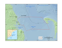
This report presents high-resolution geophysical data of the seafloor between Duxbury Beach and Provincetown, MA, in northern Cape Cod Bay (fig. 1). Approximately 480 square kilometers (km2) of the inner continental shelf were mapped focusing on the northern (deeper) section of Cape Cod Bay. This report is the fifth in a series (Barnhardt and others, 2006, 2009, 2010; Ackerman and others, 2006) published through a cooperative mapping program between the U.S. Geological Survey (USGS) and the Massachusetts Office of Coastal Zone Management (CZM) (Web address: http://woodshole.er.usgs.gov/project-pages/coastal_mass/). The long-term objectives of this mapping program are to provide a framework for scientific research and to develop geologic information to manage coastal and marine resources. High-resolution spatial data and detailed maps of seafloor geology build a foundation for protecting fish habitat, delineating marine resources, and assessing environmental changes caused by natural or human impacts. This report documents the data collection and processing methods used during the five surveys conducted between 2006 and 2008. Also included in this report are the processed geophysical datasets (bathymetry, acoustic-backscatter intensity, and seismic-reflection), seafloor photographs and, textural analyses of sediment samples. These data products are integrated within a Geographic Information System (GIS) to help guide future management decisions and will form the basis for interpretive geological maps that will be published for the region. Cape Cod Bay is a large, semi-enclosed embayment at the southernmost margin of the Gulf of Maine. It is bounded on the east and south by the Cape Cod peninsula, on the west by the mainland, and on the north it opens into Massachusetts Bay (fig. 1). The general configuration of the bay is controlled by the lithology and structural features of the region’s underlying bedrock (Oldale and Bick, 1987). During the last glaciation, a large lobe of the Laurentide Ice Sheet advanced from the north and occupied Cape Cod Bay. Sediments deposited along the margins of this ice lobe form the moraines, outwash plains, and other glacial features that characterize the region (Uchupi and others, 1996). During retreat of the ice, proglacial lakes briefly occupied the bay (Oldale, 1982) prior to marine incursion caused by rising sea level in the late Pleistocene. Following deglaciation of the region, relative sea-level change has been the major process shaping the coast and inner shelf over the last 14,500 years (Oldale and others, 1993). Shoreline regression and transgression have reworked a broad expanse of seafloor along the western margin of the bay. These shallow (0-40 m) nearshore areas are characterized by rugged rock outcrops, large piles of boulders, and relatively thin, discontinuous deposits of sand and gravel. In contrast, thick deposits of sandy and muddy sediment have accumulated in the deeper (> 40 meters) central part of the bay, creating a generally low relief, smoothly sloping seafloor (Oldale and O’Hara, 1990; Uchupi and others, 2005). |