H11997_2M_GEO: 2-m Bathymetric Grid of National Oceanic and Atmospheric Administration (NOAA) Survey H11997 Offshore in Eastern Long Island Sound (Geographic, WGS84)

Metadata also available as - [Outline] - [Parseable text]

Frequently-anticipated questions:


What does this data set describe?

Title:
H11997_2M_GEO: 2-m Bathymetric Grid of National Oceanic and Atmospheric Administration (NOAA) Survey H11997 Offshore in Eastern Long Island Sound (Geographic, WGS84)
Abstract:
The U.S. Geological Survey (USGS), in cooperation with the National Oceanic and Atmospheric Administration (NOAA), is producing detailed geologic maps of the coastal sea floor. Bathymetry and sidescan-sonar imagery, originally collected by NOAA for charting purposes, provides a fundamental framework for research and management activities in Long Island Sound, shows the composition and terrain of the seabed, and provides information on sediment transport and benthic habitat. During October 2008 NOAA completed hydrographic survey H11997 offshore in eastern Long Island Sound, and during May 2010 bottom photographs and surficial sediment data were acquired as part of a ground-truth reconnaissance survey of this area. Two interpretive data layers were derived from the multibeam echo-sounder and the ground-truth data used to verify them. For more information on the ground-truth survey see <http://quashnet.er.usgs.gov/data/2010/10015/>
  1. How should this data set be cited?

    National Oceanic and Atmospheric Administration, and U.S. Geological Survey, 2011, H11997_2M_GEO: 2-m Bathymetric Grid of National Oceanic and Atmospheric Administration (NOAA) Survey H11997 Offshore in Eastern Long Island Sound (Geographic, WGS84): Open-File Report 2010-1150, U.S. Geological Survey, Coastal and Marine Geology Program, Woods Hole Coastal and Marine Science Center, Woods Hole, MA.

    Online Links:

    This is part of the following larger work.

    Poppe, L.J., McMullen, K.Y., Ackerman, S.D., Blackwood, D.S., Schaer, J.D., Forrest, M.R., Ostapenko, A.J., and Doran, E.F., 2011, Sea-Floor Geology and Topography Offshore in Eastern Long Island Sound: Open-File Report 2010-1150, U.S. Geological Survey, Coastal and Marine Geology Program, Woods Hole Coastal and Marine Science Center, Woods Hole, MA.

    Online Links:

    Other_Citation_Details: 1 DVD-ROM

  2. What geographic area does the data set cover?

    West_Bounding_Coordinate: -72.422067
    East_Bounding_Coordinate: -72.135179
    North_Bounding_Coordinate: 41.268753
    South_Bounding_Coordinate: 41.128651

  3. What does it look like?

    <https://pubs.usgs.gov/of/2010/1150/data/bathy/grids/geo/h11997_2m_geo.gif> (GIF)
    Thumbnail image showing the 2-m gridded multibeam bathymetry collected during NOAA survey H11997 in Geographic, WGS84

  4. Does the data set describe conditions during a particular time period?

    Beginning_Date: 15-Sep-2008
    Ending_Date: 29-Oct-2008
    Currentness_Reference: ground condition

  5. What is the general form of this data set?

    Geospatial_Data_Presentation_Form: raster digital data

  6. How does the data set represent geographic features?

    1. How are geographic features stored in the data set?

      This is a Raster data set. It contains the following raster data types:

      • Dimensions 6539 x 13390 x 1, type Grid Cell

    2. What coordinate system is used to represent geographic features?

      Horizontal positions are specified in geographic coordinates, that is, latitude and longitude. Latitudes are given to the nearest 0.000021. Longitudes are given to the nearest 0.000021. Latitude and longitude values are specified in Decimal degrees.

      The horizontal datum used is D_WGS_1984.
      The ellipsoid used is WGS_1984.
      The semi-major axis of the ellipsoid used is 6378137.000000.
      The flattening of the ellipsoid used is 1/298.257224.

      Vertical_Coordinate_System_Definition:
      Depth_System_Definition:
      Depth_Datum_Name: Mean lower low water
      Depth_Resolution: 0.1
      Depth_Distance_Units: meters
      Depth_Encoding_Method: Explicit depth coordinate included with horizontal coordinates

  7. How does the data set describe geographic features?

    Entity_and_Attribute_Overview:
    A 2-m grid of the multibeam bathymetry from NOAA survey H11997 in a geographic coordinate system, WGS84.


Who produced the data set?

  1. Who are the originators of the data set? (may include formal authors, digital compilers, and editors)

  2. Who also contributed to the data set?

  3. To whom should users address questions about the data?

    U.S. Geological Survey
    c/o Larry Poppe
    Geologist
    384 Woods Hole Road
    Woods Hole, MA 02543-1598
    USA

    (508) 548-8700 x2314 (voice)
    (508) 457-2310 (FAX)
    lpoppe@usgs.gov


Why was the data set created?

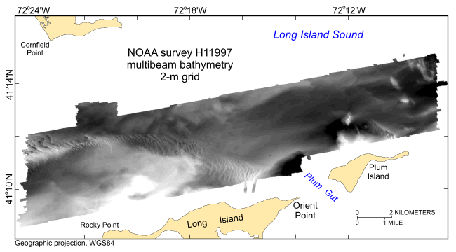
To release a 2-m grid of the multibeam bathymetry generated during NOAA survey H11997 offshore eastern Long Island Sound in geographic, WGS84.


How was the data set created?

  1. From what previous works were the data drawn?

    (source 1 of 1)
    National Ocean Survey, National Oceanic and Atmospheric Adminis, Unpublished Material, H11997 bathymetry.

    Type_of_Source_Media: disc
    Source_Contribution: Original processed multibeam bathymetric data.

  2. How were the data generated, processed, and modified?

    Date: 2008 (process 1 of 6)
    The NOAA Ship Thomas Jefferson was used to acquire the multibeam echosounder (MBES) bathymetric data for survey H11997 during September 15 - October 29, 2008 offshore in eastern Long Island Sound. The ship's MBES data were collected with a RESON 7125 system which measured two-way sound travel time across a 140-degree swath. Original horizontal resolution of the MBES data was 0.5 m for depths less than 20 m and 2 m for the deeper areas. Vertical resolution of the MBES data is about 0.5% of the water depth. The bathymetric data were acquired in XTF (extended Triton data format) and processed by NOAA using CARIS HIPS (Hydrographic Image Processing System) software for quality control, to incorporate sound velocity and tidal corrections, and to produce the continuous digital terrain model. All positioning and attitude were determined with a Trimble DSM212L DGPS receiver and an Applanix POS/MV Model 320 v.4 inertial navigation system; HYPACK MAX was used for acquisition line navigation. Sound velocity corrections were derived using frequent SeaCat SBE19 DeepCat CTD (conductivity-temperature-depth) profiles. Casts were made with a Brooke Ocean Technology Moving Vessel Profiler 100 (MVP). Typically, a CTD cast was conducted every three to four hours of MBES acquisition. Sound velocity and pressure in water were measured using a SV&P Smart Sensor housed on the MVP free fall fish. Tidal zone corrections were calculated from data acquired from National Water Level Observation stations at New London and New Haven, Connecticut. Vertical datum is mean lower low water. Individuals interested in detail descriptions of the MBES acquisition and processing should consult the descriptive report. The data were gridded to 2-m resolution and saved as a CARIS HIPS database in UTM Zone 18, NAD83.

    Person who carried out this activity:

    National Oceanic and Atmospheric Administration
    c/o Jasper Schare
    Field Operations Officer
    439 West York Street
    Norfolk, VA 23510
    USA

    757-441-6746 (voice)
    jasper.schaer@noaa.gov

    Data sources produced in this process:
    • H11997 CARIS HIPS database

    Date: 2010 (process 2 of 6)
    The gridded Base surface H11997_Combined_2m_CUBE_Deep_Final (fieldsheet H11997_Combined) was imported from the H11997 CARIS HIPS database using Fledermaus v7.1.0 beta. Defined input coordinate system as FP_NAD83_UTM_zone_18N, the output coordinate system as FP_NAD83_UTM_zone_18N, and the output SD type as SonarDTM. Created the SD file: H11997_Combined_2m_CUBE_Deep_Final.sd

    Person who carried out this activity:

    Seth Ackerman
    U.S. Geological Survey
    GIS Specialist
    384 Woods Hole Road
    Woods Hole, MA 02543-1598

    508-548-8700 x2315 (voice)
    508-457-2310 (FAX)
    sackerman@usgs.gov

    Data sources used in this process:
    • H11997 CARIS HIPS database

    Data sources produced in this process:

    • H11997_Combined_2m_CUBE_Deep_Final.sd

    Date: 2010 (process 3 of 6)
    Exported the SD file to an ArcView grid (ESRI ASCII raster file) using DMagic v7.1.0beta.

    Person who carried out this activity:

    Seth Ackerman
    U.S. Geological Survey
    GIS Specialist
    384 Woods Hole Road
    Woods Hole, MA 02543
    USA

    508-548-8700 x2315 (voice)
    508-457-2310 (FAX)
    sackerman@usgs.gov

    Data sources used in this process:
    • H11997_Combined_2m_CUBE_Deep_Final.sd

    Data sources produced in this process:

    • h11997_2m_UTM18.asc

    Date: 2010 (process 4 of 6)
    The ESRI ASCII raster file was then imported into ArcCatalog v9.3 and converted to an ESRI 32-bit floating point grid using the ASCII to Raster conversion tool (ArcToolbox - Conversion Tools - To Raster - ASCII to Raster).

    Person who carried out this activity:

    Seth Ackerman
    U.S. Geological Survey
    GIS Specialist
    384 Woods Hole Road
    Woods Hole, MA 02543-1598

    508-548-8700 x2315 (voice)
    508-457-2310 (FAX)
    ackerman@usgs.gov

    Data sources used in this process:
    • h11997_2m_UTM18.asc

    Data sources produced in this process:

    • h11997_2m_utm

    Date: 2010 (process 5 of 6)
    Defined the projection as UTM Zone 18, NAD83 using ArcCatalog v9.3 (ArcToolbox - Data Management Tools - Projections and Transformations - Define Projection).

    Person who carried out this activity:

    Seth Ackerman
    U.S. Geological Survey
    GIS Specialist
    384 Woods Hole Road
    Woods Hole, MA 02543-1598

    508-548-8700 x2315 (voice)
    508-457-2310 (FAX)
    sackerman@usgs.gov

    Data sources used in this process:
    • h11997_2m_utm

    Data sources produced in this process:

    • h11997_2m_utm

    Date: 2010 (process 6 of 6)
    The UTM grid was reprojected into a geographic grid, WGS84 using ArcCatalog v9.3 using Data Management Tools, Projections and Transformations, Raster, Project Raster). The resampling technique was bilinear; the transformation was NAD_1983_To_WGS_1984_1; other used parameters were defaults.

    Person who carried out this activity:

    Seth Ackerman
    U.S. Geological Survey
    GIS Specialist
    384 Woods Hole Road
    Woods Hole, MA 02543-1598

    508-548-8700 x2315 (voice)
    508-457-2310 (FAX)
    sackerman@usgs.gov

    Data sources used in this process:
    • h11997_2m_utm

    Data sources produced in this process:

    • h11997_2m_geo

  3. What similar or related data should the user be aware of?

    Schattgen, P. Tod , 2008, H11997: Descriptive Report H11997, National Ocean Survey, National Oceanic and Atmospheric Administration, Atlantic Hydrographic Branch, Norfolk, VA.

    Online Links:

    Poppe, L.J., DiGiacomo-Cohen, M.L., Doran, E.F., Smith, S.M., Stewart, H.F., and Forfinski, N.A., 2007, Geological interpretation and multibeam bathymetry of the sea floor in the vicinity of the Race, eastern Long Island Sound: Open-File Report 2007-1012, U.S. Geological Survey, Coastal and Marine Geology Program, Woods Hole Coastal and Marine Science Center, Woods Hole, MA.

    Online Links:

    Poppe, L.J., Denny, J.F., Williams, S.J., Moser, M.S., Forfinski, N.A., Stewart, H.F., and Doran, E.F., 2007, The geology of Six Mile Reef, eastern Long Island Sound: Open-File Report 2007-1191, U.S. Geological Survey, Coastal and Marine Geology Program, Woods Hole Coastal and Marine Science Center, Woods Hole, MA.

    Online Links:

    McMullen, K.Y., Poppe, L.J., Danforth, W.W., Blackwood, D.S., Schaer, J.D., Ostapenko, A.J., Glomb, K.A., and Doran, E.F., 2010, Surficial geology of the sea floor in Long Island Sound offshore of Plum Island, New York: Open-File Report 2010-1005, U.S. Geological Survey, Coastal and Marine Geology Program, Woods Hole Coastal and Marine Science Center, Woods Hole, MA.

    Online Links:

    Poppe, L.J., McMullen, K.Y., Ackerman, D.S., Blackwood, D.S., Irwin, B.J., Schaer, J.D., Lewit, P.G., and Doran, E.F., 2010, Sea-floor Geology and Character Offshore of Rocky Point, New York: Open-File Report 2010-1007, U.S. Geological Survey, Coastal and Marine Geology Program, Woods Hole Coastal and Marine Science Center, Woods Hole, MA.

    Online Links:

    Other_Citation_Details: 1 DVD-ROM
    McMullen, K.Y., Poppe, L.J., Danforth, W.W., Blackwood, D.S., Schaer, J.D., Guberski, M.R., Wood, D.A., and Doran, E.F., 2011, Surficial geology of the sea floor in Long Island Sound offshore of Orient Point, New York: Open-File Report 2010-1100, U.S. Geological Survey, Coastal and Marine Geology Program, Woods Hole Coastal and Marine Science Center, Woods Hole, MA.

    Online Links:

    Other_Citation_Details: 1 DVD-ROM


How reliable are the data; what problems remain in the data set?

  1. How well have the observations been checked?

  2. How accurate are the geographic locations?

    Horizontal position of the ship acquiring multibeam bathymetry was determined using differential GPS. Real-time original horizontal resolution of the MBES data was 0.5 m for depths less than 20 m and 2 m for the deeper areas; the final CARIS combined base surface for the MBES data were produced at a 2-m cell size.

  3. How accurate are the heights or depths?

    Attitude of the vessel (e.g. pitch, roll, and heave) acquiring multibeam bathymetry was monitored by an Applanix TSS POS/MV 320 Version 3 GPS aided navigation system. The vertical resolution of the original bathymetry data is approximately 0.5% of the water depth.

  4. Where are the gaps in the data? What is missing?

    All collected data were processed and used to produce this dataset.

  5. How consistent are the relationships among the observations, including topology?

    No additional checks for consistency were performed on this data.


How can someone get a copy of the data set?

Are there legal restrictions on access or use of the data?

Access_Constraints: None
Use_Constraints:
Data are not to be used for navigation purposes.

Public domain data are freely redistributable with proper metadata and source attribution. Please recognize the National Oceanic and Atmospheric Administration (NOAA) and U.S. Geological Survey (USGS) as the originators of this information.

  1. Who distributes the data set? (Distributor 1 of 1)

    U.S. Geological Survey
    c/o Larry Poppe
    Geologist
    384 Woods Hole Road
    Woods Hole, MA 02543-1598
    USA

    (508) 548-8700 x2314 (voice)
    (508) 457-2310 (FAX)
    lpoppe@usgs.gov

  2. What's the catalog number I need to order this data set?

    Downloadable Data

  3. What legal disclaimers am I supposed to read?

    Neither the U.S. Government, the Department of the Interior, nor the USGS, nor the National Oceanic and Atmospheric Administration (NOAA), nor the Connecticut Department of Environmental Protection (CT DEP) nor any of their employees, contractors, or subcontractors, make any warranty, express or implied, nor assume any legal liability or responsibility for the accuracy, completeness, or usefulness of any information, apparatus, product, or process disclosed, nor represent that its use would not infringe on privately owned rights. The act of distribution shall not constitute any such warranty, and no responsibility is assumed by the USGS, NOAA, or the CT DEP in the use of these data or related materials. Any use of trade, product, or firm names is for descriptive purposes only and does not imply endorsement by the U.S. Government.

  4. How can I download or order the data?

  5. What hardware or software do I need in order to use the data set?

    The user must have a program capable of reading the ESRI grid data format. The user must have software capable of uncompressing archived zip files, such as WinZip or Pkware. The directory structure as it appears in the WinZip file must be maintained or else the binary grid is unusable.


Who wrote the metadata?

Dates:
Last modified: 19-Oct-2010
Metadata author:
Larry Poppe
U.S. Geological Survey
Geologist
384 Woods Hole Road
Woods Hole, MA 02543-1598
USA

(508) 548-8700 x2314 (voice)
(508) 457-2310 (FAX)
lpoppe@usgs.gov

Metadata standard:
FGDC Content Standards for Digital Geospatial Metadata (FGDC-STD-001-1998)
Metadata extensions used:


Generated by mp version 2.8.25 on Tue Oct 19 11:37:55 2010