Skip past header information
USGS - science for a changing world
NOAA Logo with link to NOAA Home Page.CT DEP Logo with link to CT DEP Home Page.  

U.S. Geological Survey Open-File Report 2010–1150

Sea-Floor Geology and Topography Offshore in Eastern Long Island Sound


Skip past contents information

Title | List of Figures | Conversion Factors | Abstract | Introduction | Methods | Bathymetry | Sediment Distribution | Bottom Photography | GIS Data Catalog | Summary | Acknowledgments | References | Contacts


Figure 11. A map of the interpretations of the sea floor in the study area.

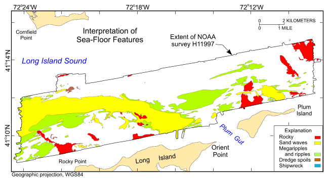
Figure 11. Interpretation of the digital terrain model from National Oceanic and Atmospheric Administration survey H11997. Areas characterized by rocky seabed, sand waves, megaripples and ripples, dredge spoils, and shipwrecks are shown. White areas within the study area are primarily winnowed sea floor armored with gravel. Shipwreck is the small blue polygon in the north-central part of the study area.

Skip USGS links group

Accessibility FOIA Privacy Policies and Notices

Take Pride in America logo USAGov logo U.S. Department of the Interior | U.S. Geological Survey
End of USGS links group