Skip past header information
USGS - science for a changing world
NOAA Logo with link to NOAA Home Page.CT DEP Logo with link to CT DEP Home Page.  

U.S. Geological Survey Open-File Report 2010–1150

Sea-Floor Geology and Topography Offshore in Eastern Long Island Sound


Skip past contents information

Title | List of Figures | Conversion Factors | Abstract | Introduction | Methods | Bathymetry | Sediment Distribution | Bottom Photography | GIS Data Catalog | Summary | Acknowledgments | References | Contacts


Figure 24. A map of sedimentary environments in the study area.

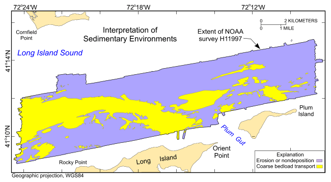
Figure 24. Distribution of sedimentary environments based on the digital terrain model from National Oceanic and Atmospheric Administration survey H11997 and verification data from U.S. Geological Survey cruise 2010-015-FA. Areas characterized by coarse bedload transport and erosion or nondeposition are shown.

Skip USGS links group

Accessibility FOIA Privacy Policies and Notices

Take Pride in America logo USAGov logo U.S. Department of the Interior | U.S. Geological Survey
End of USGS links group