Skip past header information
USGS - science for a changing world
NOAA Logo with link to NOAA Home Page.CT DEP Logo with link to CT DEP Home Page.  

U.S. Geological Survey Open-File Report 2010–1150

Sea-Floor Geology and Topography Offshore in Eastern Long Island Sound


Skip past contents information

Title | List of Figures | Conversion Factors | Abstract | Introduction | Methods | Bathymetry | Sediment Distribution | Bottom Photography | GIS Data Catalog | Summary | Acknowledgments | References | Contacts


Figure 1. A chart of grain-size relationships.

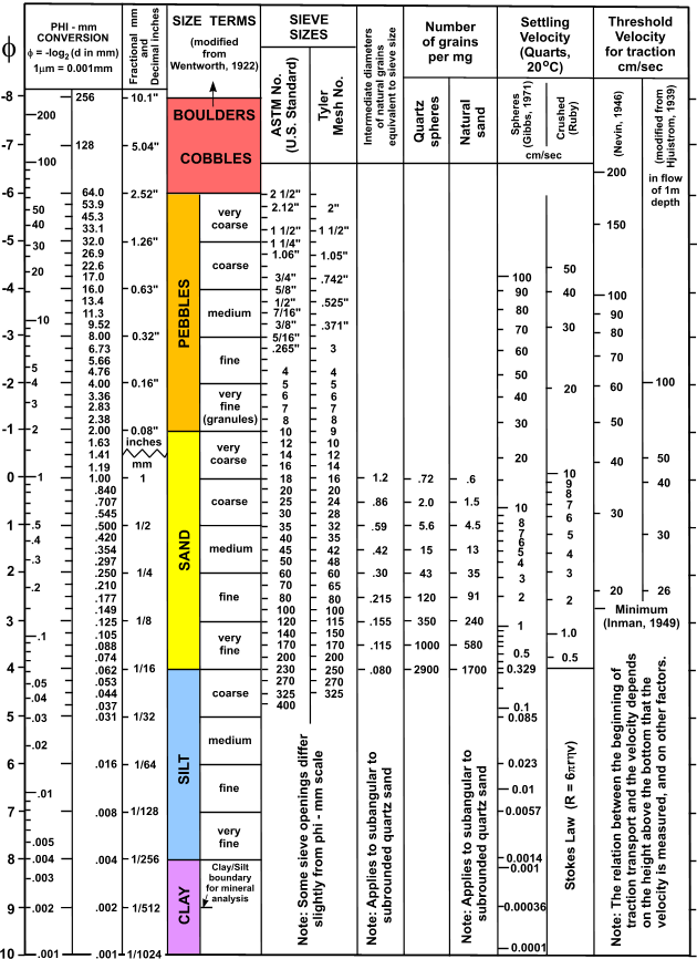
Figure 8. Correlation chart showing the relationships among phi sizes, millimeter diameters, size classifications (Wentworth, 1922), and American Society for Testing and Materials and Tyler sieve sizes. Chart also shows the corresponding intermediate diameters, grains per milligram, settling velocities, and threshold velocities for traction.

Skip USGS links group

Accessibility FOIA Privacy Policies and Notices

Take Pride in America logo USAGov logo U.S. Department of the Interior | U.S. Geological Survey
End of USGS links group