Open-File Report 2010–1208
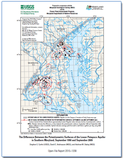
AbstractThis report presents a map showing the change in the potentiometric surface of the lower Patapsco aquifer in the Patapsco Formation of Early Cretaceous age in Southern Maryland between September 1990 and September 2009. The map, based on water-level differences obtained from 45 wells, shows that the change of the potentiometric surface during the 19-year period ranged from increases of 25 feet at Indian Head and 4 feet near the outcrop area in Glen Burnie, to declines of 35 feet at Arnold, 56 feet at Severndale, 28 feet at Crofton Meadows, 73 feet at Waldorf, 79 feet near La Plata, 35 feet at the Morgantown power plant, and 32 feet at Swan Point. The map also shows well yield in gallons per day for 2008 at wells or well fields. |
First posted December 2010
For additional information, please contact: Part or all of this report is presented in Portable Document Format (PDF); the latest version of Adobe Reader or similar software is required to view it. Download the latest version of Acrobat® Reader, free of charge. |
Suggested citation:
Curtin, S.E., Andreasen, D.C., and Staley, A.W., 2010, Difference between the potentiometric surfaces of the Lower Patapsco aquifer in southern
Maryland, September 1990 and September 2009: U.S. Geological Survey Open-File Report 2010–1208, 1 sheet, available at https://pubs.usgs.gov/of/2010/1208/.

![]() U.S. Department of the Interior |
U.S. Geological Survey
U.S. Department of the Interior |
U.S. Geological Survey
[an error occurred while processing this directive]
URL: https://pubsdata.usgs.gov
Page Contact Information: Contact USGS
Page Last Modified: Wednesday, December 07 2016, 11:00:31 PM
