Open-File Report 2010–1209
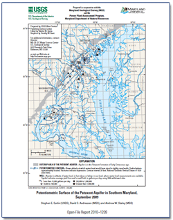
AbstractThis report presents a map showing the potentiometric surface of the Patuxent aquifer in the Patuxent Formation of Early Cretaceous age in Southern Maryland during September 2009. The map is based on water-level measurements in 42 wells. The highest measured water level was 169 feet above sea level in the outcrop area of the aquifer in northern Prince George’s County. From this area, the potentiometric surface declined south towards well fields at Glen Burnie, Bryans Road, the Morgantown power plant, and the Chalk Point power plant. The measured groundwater levels were 78 feet below sea level at Glen Burnie, 56 feet below sea level at Bryans Road, 29 feet below sea level at the Morgantown power plant, and 28 feet below sea level at the Chalk Point power plant. The map also shows well yield in gallons per day for 2008 at wells or well fields |
First posted December 2010
For additional information, please contact: Part or all of this report is presented in Portable Document Format (PDF); the latest version of Adobe Reader or similar software is required to view it. Download the latest version of Acrobat® Reader, free of charge. |
Suggested citation:
Curtin, S.E., Andreasen, D.C., and Staley, A.W., 2010, Potentiometric surface of the Patuxent aquifer in southern Maryland, September 2009: U.S. Geological Survey Open-File Report 2010–1209, 1 sheet, available at https://pubs.usgs.gov/of/2010/1209/.

![]() U.S. Department of the Interior |
U.S. Geological Survey
U.S. Department of the Interior |
U.S. Geological Survey
URL: https://pubsdata.usgs.gov/pubs/of/2010/1209/
Page Contact Information: Contact USGS
Page Last Modified: Wednesday, December 07 2016, 11:00:35 PM
