U.S. Geological Survey Open-File Report 2011–1003
Combined Multibeam and LIDAR Bathymetry Data from Eastern Long Island Sound and Westernmost Block Island Sound – A Regional Perspective
 |
||
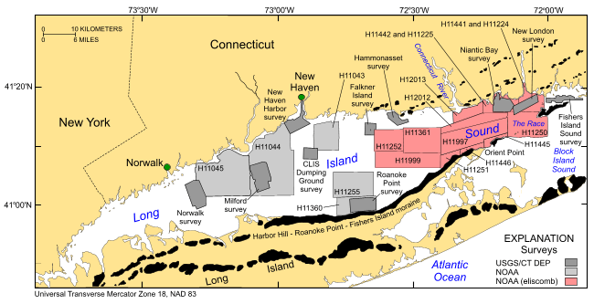
Figure 1. Location of the combined multibeam and LIDAR bathymetric dataset (eliscomb) released in this report (red polygon) and other bathymetric and backscatter surveys completed in Long Island Sound. Also shown are the locations of onshore end moraines (black polygons). Other surveys by the NOAA Ships Thomas Jefferson and Rude are shown in light gray and include H11043—Poppe and others (2004, 2006a); H11044—McMullen and others (2005), Poppe and others (2008a); and H11045—Beaulieu and others (2005); H11255—Poppe and others (2006c); H11250—Poppe and others (2006b, 2007a); H11252/H11361—Poppe and others (2007b, 2008b); H11441/H11442/H11224/H11225—Poppe and others (2010a); H11445—McMullen and others (2010); H11251—Poppe and others (2010b); H11446—McMullen and others (2011); and H11997—Poppe and others (2011). Sites of USGS sidescan-sonar surveys are shown in dark gray and include Norwalk—Twichell and others (1997); Milford—Twichell and others (1998); New Haven Harbor and New Haven Dumping Grounds—Poppe and others (2001); Roanoke Point—Poppe and others (1999a); Falkner Island—Poppe and others (1999b); Hammonasset—Poppe and others (1997); Niantic Bay—Poppe and others (1998c); New London—Lewis and others (1998), Zajac and others (2000, 2003); Fishers Island Sound—Poppe and others (1998b). | ||


