Cross, VeeAnn A. , 2014, IRB_BATHY: Esri Binary grid of the bathymetry of Indian River Bay, Delaware, generated from fathometer data acquired in April 2010 during U.S. Geological Survey Field Activity 2010-006-FA (UTM, Zone 18, WGS 84): Open-File Report 2011-1039, U.S. Geological Survey, Coastal and Marine Geology Program, Woods Hole Coastal and Marine Science Center, Woods Hole, MA.This is part of the following larger work.Online Links:
- <http://pubs.usgs.gov/of/2011/1039/data/basemap/bathy/irb_bathy.zip>
- <http://pubs.usgs.gov/of/2011/1039/html/ofr2011-1039-catalog.html>
Cross, V.A., Bratton, J.F., Michael, H.A., Kroeger, K.D., Green, A., and Bergeron, E., 2014, Continuous Resistivity Profiling and Seismic-Reflection Data Collected in April 2010 from Indian River Bay, Delaware: Open-File Report 2011-1039, U.S. Geological Survey, Reston, VA.Online Links:
This is a Raster data set. It contains the following raster data types:
Planar coordinates are encoded using row and column
Abscissae (x-coordinates) are specified to the nearest 25.000000
Ordinates (y-coordinates) are specified to the nearest 25.000000
Planar coordinates are specified in meters
The horizontal datum used is D_WGS_1984.
The ellipsoid used is WGS_1984.
The semi-major axis of the ellipsoid used is 6378137.000000.
The flattening of the ellipsoid used is 1/298.257224.
(508) 548-8700 x2251 (voice)
(508) 457-2310 (FAX)
vatnipp@usgs.gov
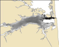
The purpose of this dataset is to provide a tide corrected bathymetric grid for the Indian River Bay.
donav:
files=`ls *.RAW | cut -d. -f1`
for file in $files
do
	awk -f awkit $file.RAW > $file.navdep
done
The AWK script "awkit" simply extracts any line of information in the HYPACK file that contains either the string "GPGGA" or "SDDBT" and writes this information to a new file with the extension navdep.
awkit:
{
if ($0 ~ /GPGGA|SDDBT/) {
	print $0
	}
}
This process step and all subsequent process steps were performed by the same person - VeeAnn A. Cross.
Person who carried out this activity:
(508) 548-8700 x2251 (voice)
(508) 457-2310 (FAX)
vatnipp@usgs.gov
Data sources produced in this process:
doholdhypack:
files=`ls *.navdep | cut -d. -f1`
for file in $files
do
	awk -f awkholdhypack $file.navdep > $file.holdhypack
done
The AWK script awkholdhypack:
BEGIN {
FS = ","
}
{
FS = ","
depth = -9999
if ($1 ~ /GPGGA/)
	{
	utctime = $2
	latdeg = substr($3,1,2)
	latmin = substr($3,3,6)
	declat = latdeg + (latmin/60)
	londeg = substr($5,1,3)
	lonmin = substr($5,4,6)
	declon = -1 * (londeg + (lonmin/60))
	if (NR==1) {
		holddepth = -9999
		}
	else {
		printf("%s, %9.6f, %9.6f, %5.1f\n", holdutctime, holddeclon, holddeclat, holddepth)
	}
	holdutctime = utctime
	holdutcdate = utcdate
	holddeclon = declon
	holddeclat = declat
	holddepth = -9999
	}
if ($1 ~ /SDDBT/)
	{
	if ($4 != "")
		{
		depthreal = $4
		holddepth = depthreal
		}
	else
		{
		depthreal = -9999
		holddepth = -9999
		}
	}
}
END {
printf("%s, %9.6f, %9.6f, %5.1f\n", holdutctime, holddeclon, holddeclat, holddepth)
}
Data sources used in this process:
Data sources produced in this process:
cat 201_1213.holdhypack \
202_1414.holdhypack \
203_1441.holdhypack \
204_1600.holdhypack > jd103hypack.csv
Data sources used in this process:
Data sources produced in this process:
Data sources used in this process:
Data sources produced in this process:
Data sources used in this process:
Data sources produced in this process:
Data sources used in this process:
Data sources produced in this process:
BEGIN {
FS=","
}
{
FS=","
hr=substr($1,1,2)
min=substr($1,3,2)
sec=substr($1,5,2)
jday = $5
longitude = $2
latitude = $3
depth = $4
printf("%s\t%s\t%s\t%s\t%9.6f\t%9.6f\t%3.1f\n", jday, hr, min, sec, longitude, latitude, depth)
}
Data sources used in this process:
Data sources produced in this process:
Data sources used in this process:
Data sources produced in this process:
awkbathy_fmt
BEGIN {
FS=","
}
{
FS=","
hr=substr($1,1,2)
min=substr($1,3,2)
sec=substr($1,5,2)
jday = $5
longitude = $2
latitude = $3
depth = $4
printf("%s\t%s\t%s\t%s\t%9.6f\t%9.6f\t%3.1f\n", jday, hr, min, sec, longitude, latitude, depth)
}
Data sources used in this process:
Data sources produced in this process:
Data sources used in this process:
Data sources produced in this process:
Data sources produced in this process:
Data sources used in this process:
Data sources produced in this process:
{
year = substr($3,1,4)
month = substr($3,6,2)
day = substr($3,9,2)
hr = substr($4,1,2)
min = substr($4,4,2)
utchr = hr + 5
tideval = $6
tideval_meters = tideval * 0.3048
printf("1\t%s\t%s\t%02d\t%02d\t%02d\t%02d\t%02.4f\t%2.3f\n", $2, year, >month, day, utchr, min, tideval_meters, tideval)
}
The first element written to the output file is the number 1. The value of this number isn't important, but the MATLAB script does expect the first element to be a number. Another important piece of information about this AWK script is that 5 is added to the hours in the tide file to convert from EST to UTC to be compatible with the bathymetry data. Also, the original tide data was recorded in feet, but the work I'm doing is in meters. So that calculation is also taken care of in the AWK script.
Data sources used in this process:
Data sources produced in this process:
%Step 1. Outside of Matlab, format the ASCII tide gauge data.
%Load the tide data.
load ir_tides.dat
load rd_tides.dat
greg_ir=ir_tides(:,3:7);  %year month day hour minute needs to be in columns 3,4,5,6,7
greg_ir(:,6)=zeros(length(greg_ir(:,1)),1);  %adding secs bc the tide file doesn't have any
greg_rd=rd_tides(:,3:7);
greg_rd(:,6)=zeros(length(greg_rd(:,1)),1);
%then establish the julian timebase for the observed tide data
jd_ir=julian(greg_ir);
jd_rd=julian(greg_rd);
h_ir=ir_tides(:,8);  %observed tide in meters (in this case above NGVD29)
h_rd=rd_tides(:,8);
%Step 2: outside of Matlab I reformatted my bathy data.  The original data was exported
%from a shapefile using XTools and then needed to be reformatted for my needs here
load bathy.dat %there are 2 bathy.dat file in 2 separate folders
jd0=julian([2010 1 1 0 0 0]);  %starting point for yearday
%setting the julian time base for the ship stuff
%this assumes column 1=jd, 2=hour, 3=min, 4=sec
jdtrack=jd0+bathy(:,1)-1+(bathy(:,2)+bathy(:,3)/60+bathy(:,4)/3600)/24;
x=bathy(:,5);  %longitude in decimal degrees in column 5
y=bathy(:,6);  %latitude in decimal degrees in column 6
htrack=bathy(:,7);
%Step 3: interpolate observed tide data onto the ship track timebase using a linear
%interpolation. Splining the tide data could result in overshoots
tidetrack_ir=linterp(jd_ir,h_ir,jdtrack);
tidetrack_rd=linterp(jd_rd,h_rd,jdtrack);
h_corrected_ir=htrack-tidetrack_ir;
h_corrected_rd=htrack-tidetrack_rd;
%Step 4: output the information I want into a text file.  I decided I basically want my
%original bathymetry data, plus the tide value and the corrected value
%I have to use the ' to get the columns flipped so the append thing works
alltidestuff=[bathy'; tidetrack_ir'; h_corrected_ir';tidetrack_rd';h_corrected_rd'];
outfile=['veetest'];
fid=fopen(outfile,'w');
fprintf(fid,'%03d:%02d:%02d:%02d, %9.6f, %9.6f, %3.1f, %3.1f, %3.1f, %3.1f, %3.1f \n',alltidestuff);
fclose(fid);
The result is a comma-delimited text file with 8 columns of information: jdtime, longitude, latitude, depth_m, ir_tide, ir_cor, rd_tide, rd_cor The definition of this header information is as follows:
jdtime: julian day and time from the GPS
longitude: longitude from the GPS
latitude: latitude from the GPS
depth_m: depth in meters of the fathometer (as recorded by the GPS)
ir_tide: interpolated tide values at the GPS time from the Indian River Inlet tide station
ir_cor: the corrected depth in meters of the fathometer based on the Indian River tide value (depth_m - ir_tide)
rd_tide: interpolated tide values at the GPS time from the Rosedale Beach tide station
rd_cor: the corrected depth in meters of the fathometer based on the Rosedale tide value (depth_m - rd_tide)
The header line was added to the veetest file and saved under a new file name: hypbathytides.csv and jd105_moredepths.csv
Data sources used in this process:
Data sources produced in this process:
Data sources used in this process:
Data sources produced in this process:
Data sources used in this process:
Data sources produced in this process:
Data sources used in this process:
Data sources produced in this process:
Data sources used in this process:
Data sources produced in this process:
wt_tide = ((1-([dist_rose]/( [dist_rose] + [dist_inlet])))* [rd_tide]) + ((1-( [dist_inlet]/( [dist_rose] + [dist_inlet])))* [ir_tide])
This should give a weighted tide value for each point based on the distance to each tide station. Now apply the tide correction: tideadded = [depth_m] - [wt_tide]
Data sources used in this process:
Data sources produced in this process:
Inputs:
bounding_poly; ; boundary
jd105_moredepths_utm18; wttide_dep; PointElevation
hypbathytides_utm18; wttide_dep; PointElevation
output: bestbathy
cell size: 25
drainage enforcement: no_enforce
primary type of input data: spot
Everything else left to defaults.
The bounding polygon was a quick polygon created around the survey area to limit the extent of extrapolation in areas where no data were available.
Data sources used in this process:
Data sources produced in this process:
Input: bestbathy
Output: bestbat_fil
Filter type: low
Check the box next to ignore NODATA in calculations.
Data sources used in this process:
Data sources produced in this process:
Data sources used in this process:
Data sources produced in this process:
Data sources used in this process:
Data sources produced in this process:
The navigation system used was a Lowrance 480M with an LGC-2000 Global Positioning System (GPS) antenna. The antenna was located directly above the fathometer transducer mount point.
All collected bathymetry values were collected by the 200 kHz Lowrance fathometer. The fathometer was mounted starboard side aft, directly below the GPS antenna and the resistivity streamer tow point. The Lowrance manufacturer indicates the speed of sound used by the system to convert to depths is 4800 feet/second. All values are assumed to be accurate to within 1 meter. The gridding, grid smoothing, and other processing affects the accuracy of individual cell values as these data were not collected with the intention of generating a grid and have areas of sparse coverage.
This grid represents all the valid fathometer readings recorded by the HYPACK navigation software, plus some bathymetric readings recorded by the continuous resistivity profile system when the HYPACK system was not logging data.
All the data were evaluated with the same criteria.
Are there legal restrictions on access or use of the data?
- Access_Constraints: None.
- Use_Constraints:
- Not to be used for navigation. The public domain data from the U.S. Government are freely redistributable with proper metadata and source attribution. Please recognize the U.S. Geological Survey as the originator of the dataset.
(508) 548-8700 x2251 (voice)
(508) 457-2310 (FAX)
vatnipp@usgs.gov
Downloadable Data
Neither the U.S. government, the Department of the Interior, nor the USGS, nor any of their employees, contractors, or subcontractors, make any warranty, express or implied, nor assume any legal liability or responsibility for the accuracy, completeness, or usefulness of any information, apparatus, product, or process disclosed, nor represent that its use would not infringe on privately owned rights. The act of distribution shall not constitute any such warranty, and no responsibility is assumed by the USGS in the use of these data or related materials. Any use of trade, product, or firm names is for descriptive purposes only and does not imply endorsement by the U.S. Government.
| Data format: | The WinZip (v. 14.0) file contains the Esri binary grid - data contained in the grid folder and the info folder, as well as the associated metadata files. in format AIG (version 9.2) Size: 0.25 |
|---|---|
| Network links: |
<http://pubs.usgs.gov/of/2011/1039/data/basemap/bathy/irb_bathy.zip> <http://pubs.usgs.gov/of/2011/1039/html/ofr2011-1039-catalog.html> <http://dx.doi.org/10.3133/ofr20111039> |
This WinZip file contains data available in Esri binary grid format. The user must have software capable of uncompressing the WinZip file and reading/displaying the grid.
(508) 548-8700 x2251 (voice)
(508) 457-2310 (FAX)
vatnipp@usgs.gov