U.S. Geological Survey Open-File Report 2011-1127
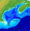
Construction of a 3-Arcsecond Digital Elevation Model for the Gulf of Maine
The Digital Elevation Model can be obtained as a 32-bit GeoTIFF file, a NetCDF file, a ZIP file containing an ESRI ASCII Grid, or via the web services provided by the THREDDS Data Server (Table 3). These services include:
Table 3. Methods for downloading the bathymetry grid used in developing the digital elevation model for the Gulf of Maine.
|